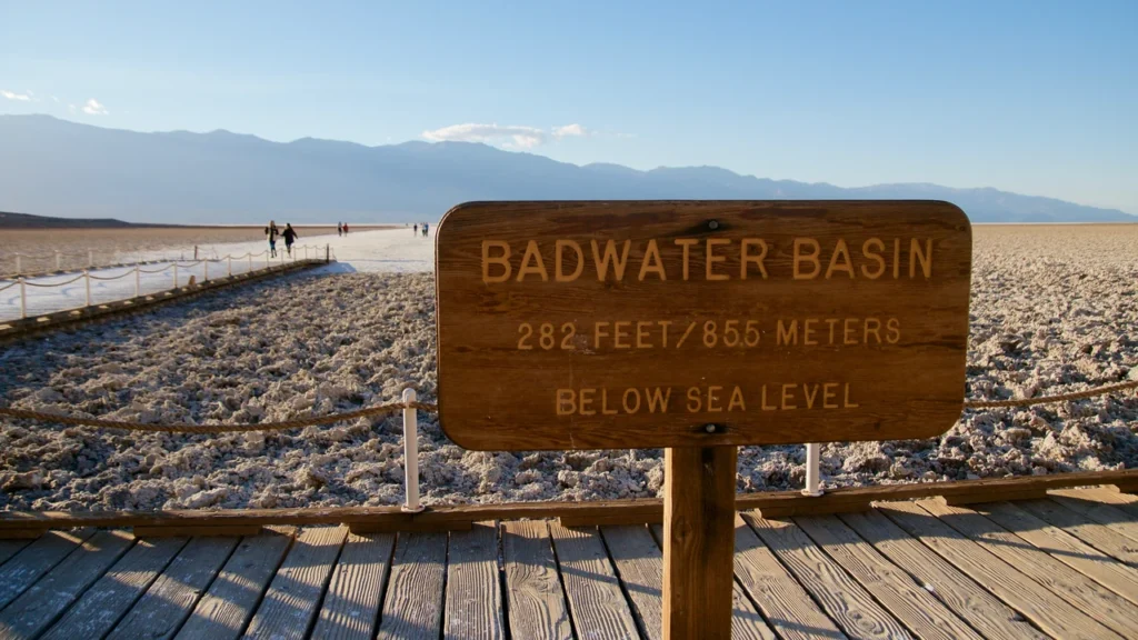
Badwater Basin is the part of Death Valley that reaches 282 feet (86 meters) below sea level. You don’t have to walk to the lowest part of the salt flat to see what that means. From the visitor boardwalk, look back up at the cliff: the small sign on the rock shows the height of sea level. The low floor extends west in the opposite direction, well beyond the parking area.
Badwater Basin reaches 282 feet (86 meters) below sea level, the lowest land in North America. The cliff sign above the visitor boardwalk marks sea level; it does not mark the deepest part of the basin. At Badwater, the road and boardwalk are on the eastern edge of a much wider low area.
How to use this article: Find the right stop for your visit, see where the sign and lowest floor are, or check the roads before driving.
Badwater Basin map and visit choices
Choose between a roadside stop and a salt-flat walk
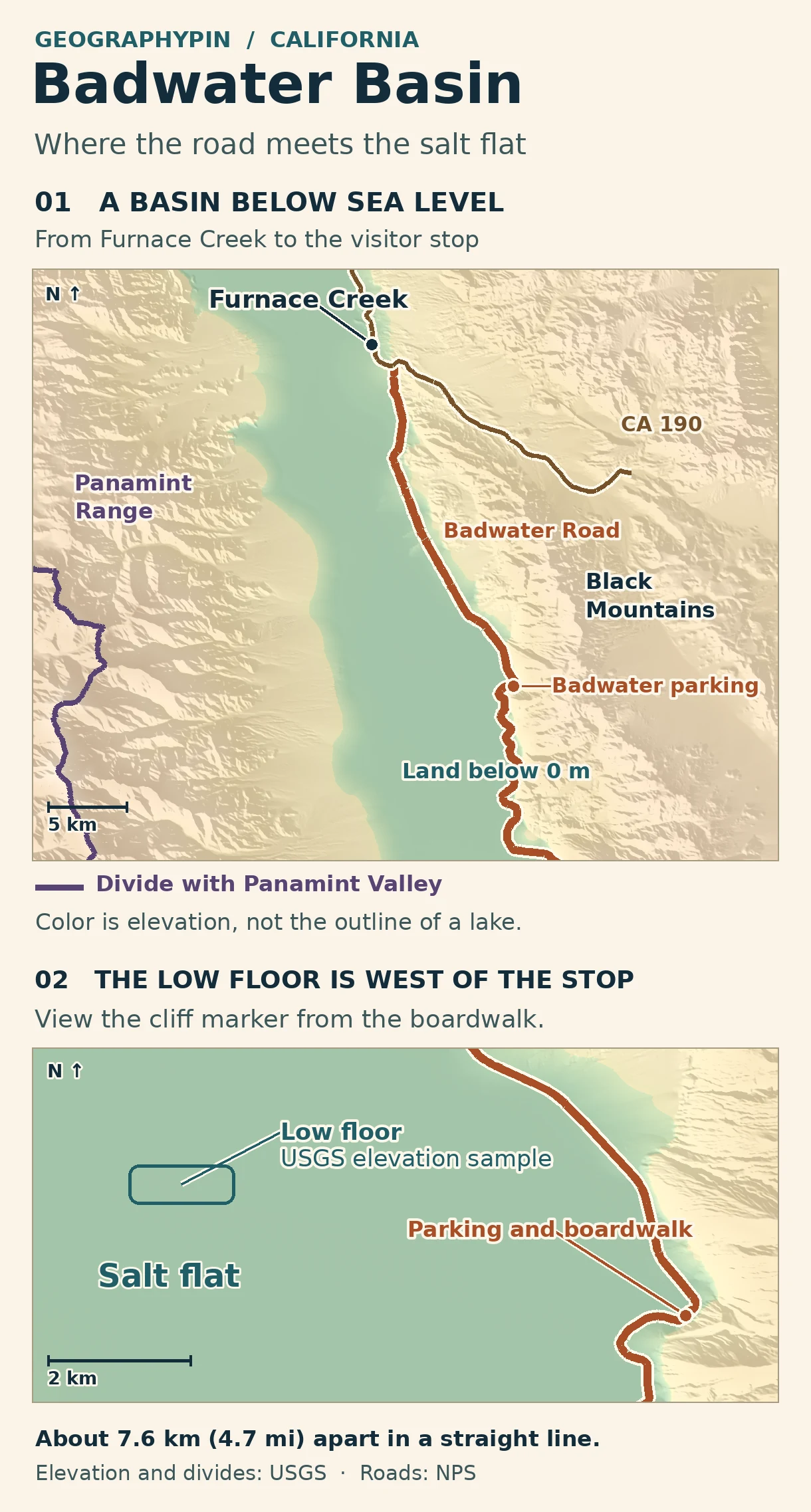
From the CA 190 junction near Furnace Creek, the park describes the drive to Badwater parking as about 17 miles (27 km) south on Badwater Road. That is a one-way driving distance. The walk starts at the parking area beside the Black Mountains, not at Furnace Creek.
| If you want to see… | Start here | What it involves |
|---|---|---|
| The basin without an exposed walk | Badwater parking | View the flats from the lot or your vehicle, especially in hot weather. |
| The spring and sea-level reference | Short boardwalk below the parking area | Look up toward the cliff on the east. NPS describes a ramp to the boardwalk. |
| A wider view of the salt polygons | Continue west beyond the boardwalk if conditions allow | NPS describes about 1 mile round trip to the edge of the flat, or 1½ to 2 miles round trip for farther-out views. |
The boardwalk, the cliff sign and the low floor
Where the signs tell you to look
The brown sign at the visitor stop gives the basin’s familiar 282-foot figure. The small sign high on the rock face marks a different thing: the height of sea level. If you face west toward the flats, the cliff sign is behind you. Neither sign is a survey marker locating the deepest spot under your feet. The U.S. Geological Survey also describes the Badwater site as close to the basin’s lowest point rather than the point itself.
The distinction is easy to see in the elevation data. In the detailed map window, the lowest sampled cell is on the interior flat, about 4.7 miles (7.6 km) west-northwest of the parking reference. That is straight-line separation, not hiking distance. The inset marks a low area, not a coordinate to hike to. The landscape is so nearly level there that a change in the elevation grid can change which cell comes out lowest.
Why water collects in Death Valley
Below sea level does not mean connected to the sea. The mountains around the valley act as divides. Rain falling on different sides of the divide with Panamint Valley drains into different basins, even where both destinations have no outlet to the ocean. On the Death Valley side, runoff can reach the salt pan; the USGS documented Amargosa River floodwater reaching Badwater during the February 1998 storms. As pooled water evaporates, salts remain behind.
After heavy rain, the place where dry salt ends can shift. A December 4, 2025, park report put temporary water roughly a mile from the lot at the time. That is an observation from that event, not a distance to today’s shoreline. A longer walk does not necessarily get you to the dry polygons if the route has become wet or muddy.
Driving and walking when conditions change
Check the approach and the walk separately
Roads checked November 21, 2026: the NPS road map showed the Badwater Road approach from CA 190 and the Badwater parking road as open. Caltrans reported no restrictions for the SR 190 area at its early-morning update. Those checks describe the roads, not the walking surface or the presence of water. Reopen both sources on your travel day.
If you are coming from the south, check that approach independently. The park reopened South Badwater Road in January 2026 after months of flood damage. A closure on the south side of the basin can prevent a through drive without making the stop unreachable from Furnace Creek. A closure on the road between Furnace Creek and Badwater changes the northern approach itself. Do not use dirt roads as a bypass or drive through floodwater.
For the walk, the park’s Badwater guidance advises against hiking after 10 a.m. in summer. That is not a guarantee that earlier hours are safe. In extreme heat, choose the parking-area view rather than the exposed salt flat. After rain, look for ranger guidance or posted closures even when the paved road is open.
Frequently Asked Questions
Does the ramp mean the whole salt-flat route is wheelchair accessible?
No. The park identifies the ramp and boardwalk separately from the route across the salt. Its accessibility assessment notes that windblown salt can build up on approaches. Ask the park about the condition of the ramp and viewing area for your day.
Is the spring by the boardwalk part of the temporary lake?
They have different sources. The small Badwater Spring pool is groundwater fed, while the broad sheet on the flats forms after rain and runoff. NPS rules prohibit wading and swimming in Badwater Spring, and the park’s Badwater page separately prohibits launching watercraft on temporary Lake Manly.
Where can you see the shape of the basin from above?
Dantes View is a separate overlook reached by its own road off CA 190. It shows the valley floor from the Black Mountains. It is not an uphill walk from the Badwater lot, so check the overlook road separately.
What Did We Learn Today?
Use the cliff sign to see where sea level would be and the terrain map to see how far the low ground extends. The parking area is the access point, not the lowest survey location. Check the road first and then decide whether the salt-flat walk makes sense for that day.
Sources & Data Notes
Open the road status, elevation data and photograph credit
- NPS Badwater Basin and NPS visitor activity describe different walking endpoints. About ¼ mile reaches some salt polygons on the activity page; the place page distinguishes about a 1-mile round trip to the edge and a longer walk for views farther out. No distance is promised after floods.
- NPS conditions and Caltrans SR 190 report, checked November 21, 2026. NPS page updated November 19; November 21 road verification uses the embedded official status layer, not an inference from the page’s closure headlines.
- Map: GeographyPin, drawn from USGS 3DEP National Map elevation and the Watershed Boundary Dataset at HUC8 scale. The divide shown is the shared segment of Death Valley–Lower Amargosa and Panamint Valley, not a full catchment outline or the zero contour. Zero on the map is the gridded North American Vertical Datum of 1988, not a local water level. Both DEM extracts were fetched November 21, 2026; this is not their terrain acquisition date. The minimum of the detailed grid is about −85.1 m, which does not replace the park’s published basin figure. Distance is from the mapped parking road to the low-cell center, rounded to 0.1 km or mile.
- Photograph: Badwater Basin sign from the boardwalk, Sylvain Kalache, December 17, 2016. CC BY 2.0; cropped, resized and converted to WebP. Not a photograph of current water or trail conditions.
