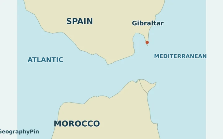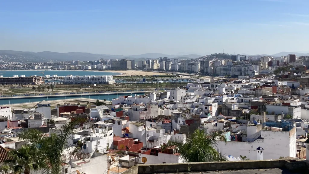
Tangier is on Morocco’s north coast, where the Strait of Gibraltar opens toward the Atlantic. Its old city overlooks Tangier Bay and the city ferry port, Tanger Ville. The other major ferry port, Tanger Med, is farther east in a different province, and the same distinction matters when reading maps and population figures.
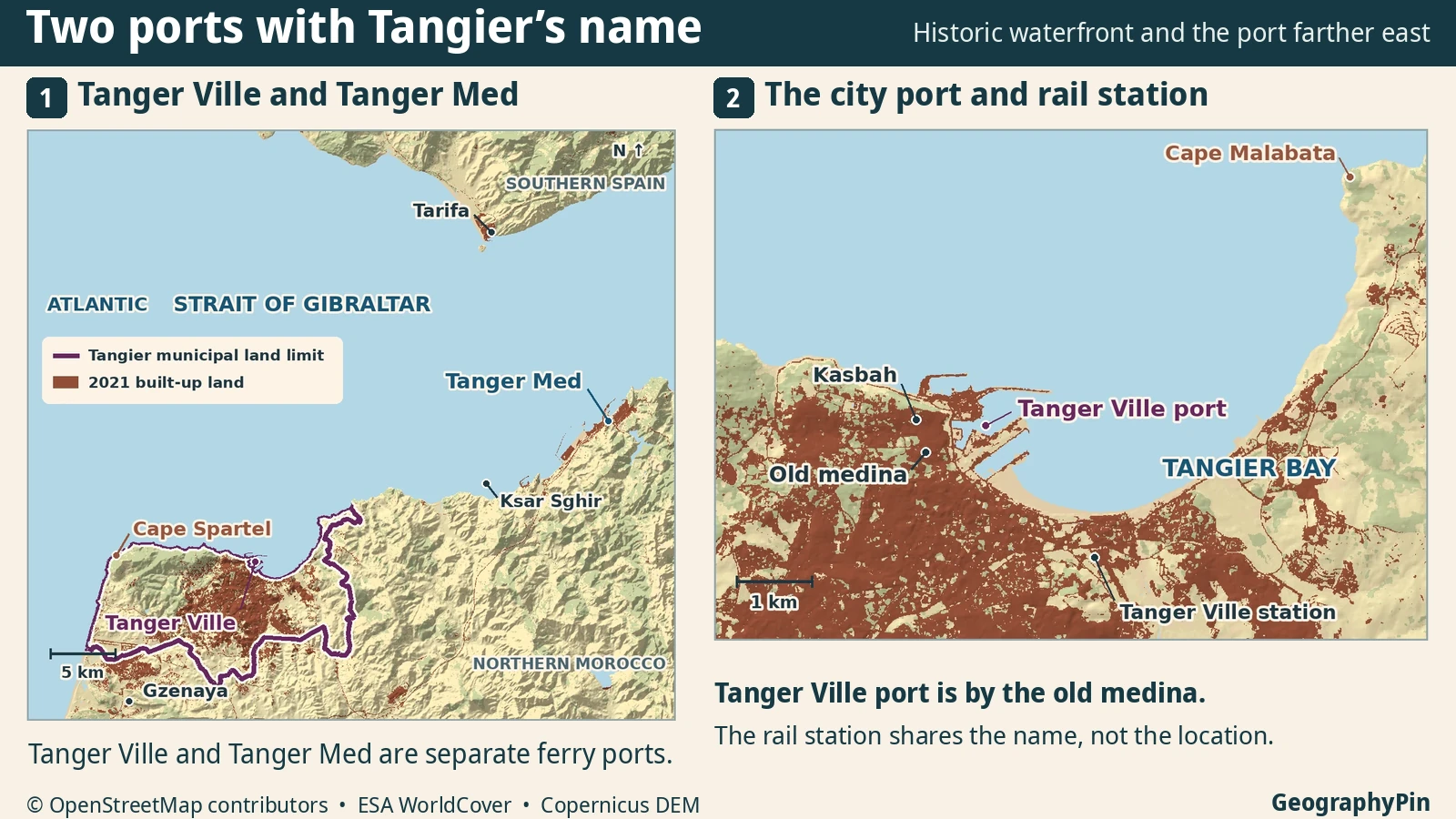
Port Tanger Ville is on Tangier Bay just below the old city. Tanger Med is a different ferry and cargo port east of Tangier, in Fahs-Anjra Province. On a map, Cape Spartel marks the turn toward the Atlantic on the other side of the city.
Start at the bay: Compare the two locations on the map, check the names used for ports and rail or see which population belongs to Tangier.
The city of Tangier and its municipal boundary
Tangier sits on the Moroccan side of the western entrance to the Strait of Gibraltar, at the northwestern end of the country. Its older neighborhoods stand above the west end of Tangier Bay. The newer waterfront follows the curve of the bay farther east. Cape Spartel lies to the west of both, where the coast bends toward the Atlantic.
Tanger is the spelling used by the municipality and most French-language maps; Tangier is the usual English spelling. Both refer to the same city, the capital of the Tanger–Tétouan–Al Hoceima region. The commune de Tanger is the municipal unit. Its four administrative districts are Tanger-Médina, Bni Makada, Charf-Souani and Charf-Mghogha. Tanger-Médina on a census map includes far more than the lanes inside the historic walls.
The regional map shows why the city boundary is useful. It encloses the western headland area as well as the dense city around the bay, but there is more built-up land beyond the municipal extent. Gzenaya, also written Gueznaia, has its own commune and separate census count. Tanger Med lies farther east again, beyond the city and in a different province.
The old waterfront below the medina
At the western side of the bay, the older city occupies higher ground just inland from the port. The Kasbah sits above the medina; below, the historic port connects to the lanes near Bab Al Marsa. The city describes the former customs building there as the present Port Center, near the ferry and cruise terminals. That old customs building helps locate the point where the walled city and port meet.
Continue southeast around Tangier Bay and the character of the waterfront changes. The shore curves away from the old harbor and toward Cape Malabata on the other side of the bay. Buildings and beaches follow that curve, while the Kasbah and its adjoining lanes remain concentrated at the west end. On a map of the whole city, a dot saying “Tangier” cannot show those different settings.
Tanger Ville is also the name of a railway station served by ONCF’s Al Boraq trains. The station sits farther around the bay than the ferry terminal. The two names both distinguish places in the city, but “Ville” alone is not an address: for rail look for gare; for the ferry look for port.
Cape Spartel marks the turn toward the Atlantic
The old harbor opens onto Tangier Bay and the strait. West of town, the coast reaches the headland of Cape Spartel, also called Ras Spartel. Around it, the shoreline turns south along the Atlantic-facing side. The difference is a turn in the direction of the land, not a visible seam between bodies of water.
The lighthouse at Cape Spartel dates to 1864. The headland and Cape Trafalgar across the entrance in Spain are used as references for the western limit of the strait. The atlas gives the two broad settings rather than drawing a line across the water. A named geographic limit is not a political boundary, nor does it tell you what the currents are doing on a particular day.
Tanger Ville and Tanger Med are not the same port
Tanger Ville is the passenger port beside the old city. Tanger Med is a separate complex farther east along the strait, in Fahs-Anjra Province. The distance depends on where you start in Tangier and which road you follow. The port authority lists 35 kilometers from eastern Tangier and 54 kilometers via the Tangier–Tanger Med motorway route. Those are access distances with different starting points, not the length of a direct trip from the Kasbah.
A Tarifa–Tanger Ville ferry ends beside the medina; an Algeciras–Tanger Med ferry uses the port east of town. Check the ports and travel mode printed on your ticket: some itineraries sold from Algeciras include a bus transfer to the ferry at Tarifa.
| Name | What and where it is |
|---|---|
| Port Tanger Ville | City ferry port beside the medina; operators list Tarifa among its links |
| Tanger Med | Eastern port complex with passenger and cargo facilities; its operator lists Algeciras among its links |
| Gare Tanger Ville | ONCF railway station in Tangier, not a ferry terminal |
The port group opened its first container terminal at Tanger Med in 2007 and inaugurated a separate passenger and roll-on/roll-off port in 2010. Roll-on/roll-off means vehicles can be driven directly onto and off a ship. Those facilities have a different role and a different address from the old city docks. The listed cross-strait examples help decode the names, but the terminal on the actual ticket is the one to use.
What a Tangier population figure actually counts
Morocco’s High Commission for Planning counted 1,275,428 people in the Tangier municipality in 2024. Tanger-Assilah Prefecture contains Tangier but also separate communes, including Gzenaya and Assilah. It had 1,494,413 people in the same census. The difference is not the population of a neatly defined “suburban ring”; it covers everywhere else in the prefecture, including towns separated from Tangier by open land.
| Boundary | People |
|---|---|
| Tangier municipality | 1,275,428 |
| Tanger-Assilah Prefecture, including the city | 1,494,413 |
| Fahs-Anjra Province, containing Tanger Med | 100,789 |
| Total of both jurisdictions | 1,595,202 |
The Tangier Urban Agency calls its two-jurisdiction planning territory Grand Tanger. It covers the prefecture and Fahs-Anjra Province. That name fits a map of the city and its port corridor, but the combined number is not an independently measured commuting area or a count of people in one continuous built-up zone. When a source gives a larger number for Tangier, check which line it drew before comparing it with another city.
Frequently Asked Questions
Where should I look for the historic center on a map?
Look for the old medina and the Kasbah at the west end of Tangier Bay, just above Port Tanger Ville. A map of the wider Tanger-Médina administrative district will cover considerably more ground.
Does Tanger Ville on my ticket mean the ferry port or the train station?
Check the operator and the mode of transport. Port Tanger Ville is the city ferry terminal by the medina. Gare Tanger Ville is the ONCF railway station farther around the bay.
Is Gzenaya one of Tangier’s four districts?
No. HCP counted Gzenaya as a separate commune of 88,676 people in 2024. It shares the prefecture with Tangier, which is why both appear in the larger prefecture total.
What Did We Learn Today?
Tangier’s old city overlooks a bay on the Strait of Gibraltar, with the Atlantic-facing coast around Cape Spartel to the west. Port Tanger Ville is below the medina, while Tanger Med is in a different province to the east. The municipality, prefecture and wider planning area count different places even though all share Tangier’s name.
Sources & Data Notes
- Tangier municipality and four districts; Tangier Urban Agency, administrative geography; agency usage of Grand Tanger. This is a planning jurisdiction, not a commuter catchment.
- Haut-Commissariat au Plan, RGPH 2024 legal population by municipality and district, page 41; regional demography, including Fahs-Anjra Province. The broad-area total is the arithmetic sum of the full prefecture and full province, without adding Tangier again. Resident totals are from the same 2024 census.
- Tangier municipality, old port customs building and medina; Cape Spartel; IALA, Cape Spartel lighthouse and the western entrance; NOAA, named limit of the Strait of Gibraltar; NGA geographic reference for Tangier Bay and Pointe Malabata. The map does not show a maritime jurisdiction or an exact water-mass boundary.
- Tanger Ville ferry port; Baleària, city-port link to Tarifa; Tanger Med access and distances; Tanger Med routes; Tanger Med port history; Tanger Med authority’s filing for its Fahs-Anjra location; ONCF, Tanger Ville train station name. Links verify the names and typical connections; no current timetables or boarding instructions are quoted.
- Map: GeographyPin. City polygon relation 2758781, © OpenStreetMap contributors, generalized and clipped to land. Built-up land and water from ESA WorldCover 2021 v200, CC BY 4.0; © ESA WorldCover project 2021 / Contains modified Copernicus Sentinel data (2021) processed by ESA WorldCover consortium. Relief produced using Copernicus WorldDEM-30 © DLR e.V. 2010-2014 and © Airbus Defence and Space GmbH 2014-2018 provided under COPERNICUS by the European Union and ESA; all rights reserved.
- Featured image: Panorama Tanger Bay Tangier Marokko, Herbert wie, February 21, 2024; cropped, resized and converted to WebP. The adapted photograph remains under CC BY-SA 4.0.
- DFDS: Algeciras–Tarifa connecting bus on selected Tanger Ville itineraries.