Valparaíso is a Pacific port in central Chile. A narrow strip of lower city fits between the harbor and steep hills, while the built-up coast continues northeast into Viña del Mar. That is why the city on a map can look larger than Valparaíso municipality: the streets continue, but the municipal boundary still cuts across them.
Valparaíso municipality meets Viña del Mar along the same bay. Its port, lower strip called El Plan and steep hillside neighborhoods sit at the southwestern end. Chile’s 2024 census counted 284,938 in the municipality and 970,233 across the five municipalities that make up the official metropolitan area.
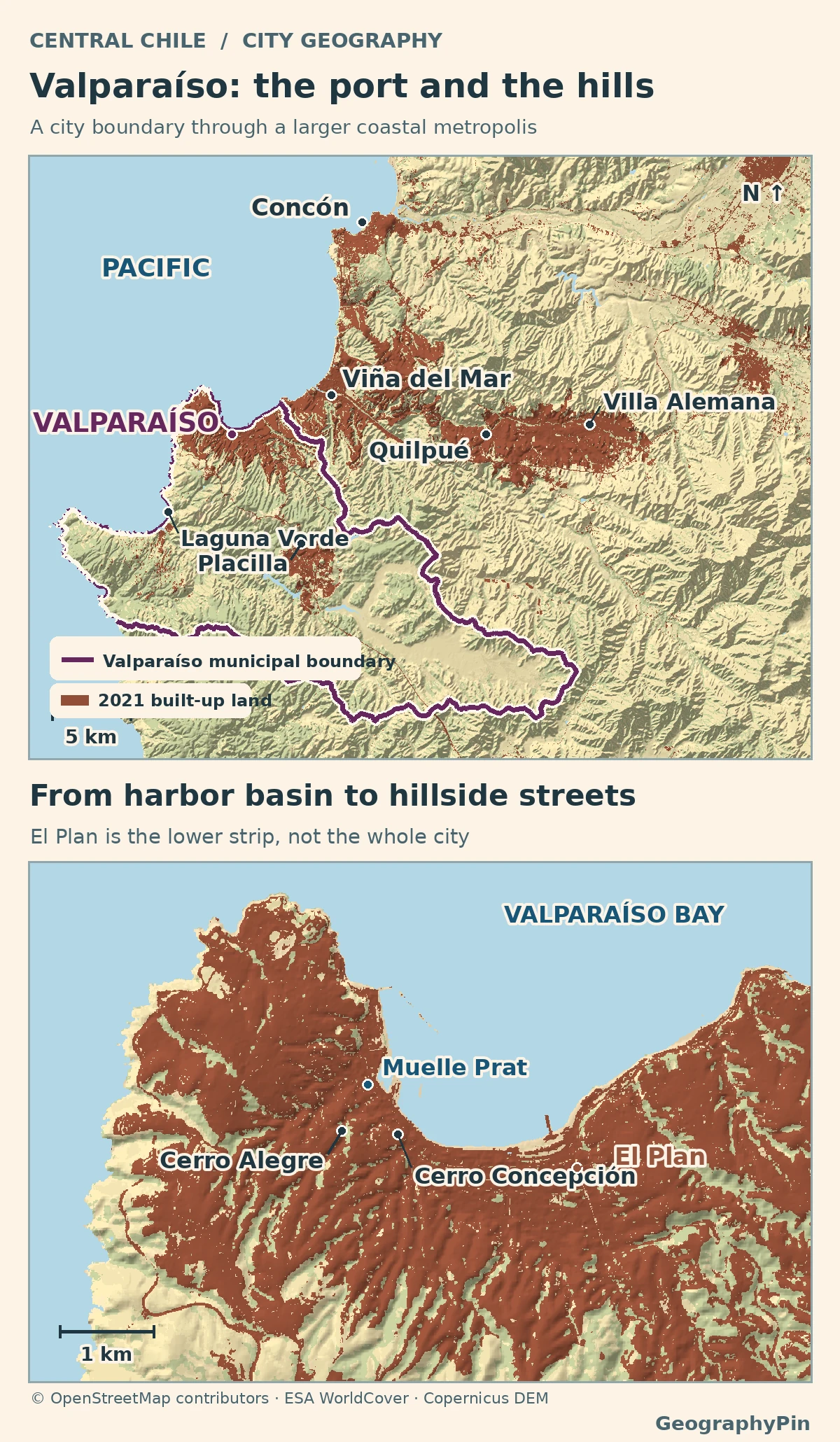
Read the map from the bay inland: Locate the city boundary, see where the port gives way to El Plan and compare the city and Greater Valparaíso counts.
Where the municipality ends and the city keeps going
The mapped boundary excludes the offshore islands
Valparaíso is on Chile’s central Pacific coast, northwest of Santiago. The port city occupies the southwestern curve of the bay, while neighboring Viña del Mar lies to the northeast. Follow the shoreline toward Viña and there is no broad stretch of countryside to announce the change of municipality. Chile’s boundary decree puts the coastal handover along the line of Subida El Sauce, extended toward the sea. Inland, the line follows a more complicated sequence of streets, ravines and ridges rather than the edge of continuous settlement.
That does not mean the entire municipality sits around the harbor. The Chilean comuna, or municipal territory, also includes the separate settlements of Laguna Verde and Placilla de Peñuelas, including the Curauma sector. The regional map shows these places south and southeast of the main city. The rule works both ways: there is built-up land outside the municipality on the Viña side, and the municipality contains land well beyond the main waterfront city.
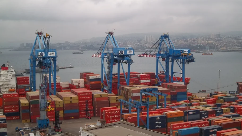
The working port and the narrow strip called El Plan
Find the port and El Plan
From the water, three bands of the city are easy to pick out. There are breakwaters, piers and working terminals at the bay. Behind them is El Plan, the lower, flatter belt along the waterfront. Then there is the foot of the slope, where streets and stairs start climbing the hills. UNESCO describes much of that narrow coastal plain as artificial. The modern waterfront is not a simple line left by the natural beach.
At Muelle Prat, the port and lower city meet near Plaza Sotomayor. The pier is a landmark beside the working harbor, not another name for the port’s two commercial terminals. The port authority identifies Terminal 1 as TPS and Terminal 2 as TPV. A map that labels the whole lower city “the port” hides streets and squares used for ordinary city life; a map that shows only the old buildings leaves out the industrial waterfront beside them.
The physical squeeze is easy to see on the enlarged detail. Several uses that could spread out across a broad plain in another city have to share the narrow strip around the bay. Just inland, the hillside breaks that strip into routes that take people uphill rather than along the waterfront.
Why the hills are not one uniform slope
The hills rise around the bay in a rough semicircle, cut by ravines called quebradas. Streets laid along one ridge do not necessarily continue across the next ravine. Two places with a short straight-line distance between them may be linked by stairs, a bend in the road, or a route down toward El Plan and back up again. The shape of the ground explains why a street map looks so different above and below the foot of the hills.
Cerro Alegre and Cerro Concepción are neighboring hills above the central waterfront. Their lanes, stairs and upper funicular stations help explain the transition between the lower city and the higher neighborhoods. An ascensor in this context is an inclined lift or funicular, not a vertical elevator in a building. The historic installations are evidence of how people adapted transport to the slope; a mapped installation does not establish that it is running today.
For one named ascent, look for El Peral near Plaza de Justicia. It climbs to Paseo Yugoslavo on Cerro Alegre; the museum also identifies stairs alongside it. Confirm whether the funicular is operating before relying on it.
UNESCO inscribed the Historic Quarter of the Seaport City of Valparaíso in 2003, not the entire municipality. The inscribed property covers 23.2 hectares, with a separately documented 44.5-hectare buffer zone. It includes selected hillside streets as well as parts of the lower city around Prat Pier and Plaza Sotomayor. The listing follows the connection between the hills and harbor but does not extend to every hillside or quay.
What counts as Greater Valparaíso?
Compare the municipal and metropolitan areas
Chile’s January 2026 decree established the Área Metropolitana del Gran Valparaíso using five municipalities: Valparaíso, Viña del Mar, Concón, Quilpué and Villa Alemana. That is an official area for metropolitan administration. Its combined population includes all residents counted in those five municipalities, not just residents of neighborhoods that form one uninterrupted patch of buildings.
| Municipality or total | Residents counted |
|---|---|
| Valparaíso | 284,938 |
| Viña del Mar | 334,871 |
| Quilpué | 162,559 |
| Villa Alemana | 139,571 |
| Concón | 48,294 |
| Five-municipality total | 970,233 |
The decree itself gives 951,311 people because it uses the 2017 census. The larger number above is the sum of the same five municipalities from the 2024 census, not an estimate for the date the decree was published. Nor is it the total for the entire Valparaíso Region, which had 1,896,053 residents in the same census.
Even that defined metropolitan area does not capture every working connection. The Limache–Puerto train runs from Valparaíso through Viña del Mar, Quilpué and Villa Alemana to Limache, outside the five-municipality area. Limache being on the line does not make it part of the official metro total. For population comparisons, match like with like: one municipality against another, or the same kind of metropolitan area from the same census year.
Frequently Asked Questions
Is Valparaíso the capital of Chile?
No. Santiago is the national capital; Valparaíso is the seat of the National Congress and the capital of the Valparaíso Region.
Why does the municipal map leave out some Pacific islands?
San Félix and San Ambrosio belong to Valparaíso municipality under Chile’s administrative boundary decree. They are far offshore and are not part of the mainland conurbation shown on the map.
Is Puerto the name of a railway station or a port terminal?
Estación Puerto is the railway station at the Valparaíso end of the Limache–Puerto service. The commercial port terminals, numbered 1 and 2, are separate facilities.
What Did We Learn Today?
Valparaíso’s port, El Plan and hillside streets share a narrow stretch of coast. The city’s buildings continue into neighboring municipalities, but the legal boundaries still matter when counting people. The five municipalities of Greater Valparaíso counted 970,233 residents in 2024; only 284,938 were in Valparaíso municipality itself.
Sources & Data Notes
- Biblioteca del Congreso Nacional, municipal boundary law locates the boundary at Subida El Sauce and includes San Félix and San Ambrosio. Regional planning ordinance identifies Laguna Verde and Placilla, including Curauma. Library of Congress, congressional seat.
- Chile INE, 2024 census counts by comuna; explanation of residence and census dates; decree establishing five metropolitan communes, published January 20, 2026. The 970,233 figure is the sum of the listed 2024 counts; the decree’s 951,311 uses 2017 data. Chile government, regional scope and 2024 population.
- UNESCO, Historic Quarter of the Seaport City of Valparaíso and inscribed property map and area; Chile National Monuments Council, historic area and lower-city planning. The article’s atlas labels places, not a World Heritage property or buffer boundary.
- Puerto Valparaíso, 2025 annual report and port operator’s terminal and pier pages; regional government, Estación Puerto and Limache–Puerto train and served municipalities. No current schedules or terminal permissions assessed.
- Map: GeographyPin. Mainland municipal outline from relation 110808, © OpenStreetMap contributors, generalized and clipped to land. Built-up land and water from ESA WorldCover 2021 v200, CC BY 4.0; © ESA WorldCover project 2021 / Contains modified Copernicus Sentinel data (2021) processed by ESA WorldCover consortium. Relief produced using Copernicus WorldDEM-30 © DLR e.V. 2010-2014 and © Airbus Defence and Space GmbH 2014-2018 provided under COPERNICUS by the European Union and ESA; all rights reserved.
- Featured image: Puerto de Valparaíso desde el Cerro Artillería 3, Dario Alpern, July 24, 2011; cropped, resized and converted to WebP. The adapted photograph remains under CC BY-SA 3.0. It shows the port landscape in 2011, not a current inventory of facilities.
- Museo de Historia Natural de Valparaíso: El Peral and Paseo Yugoslavo.