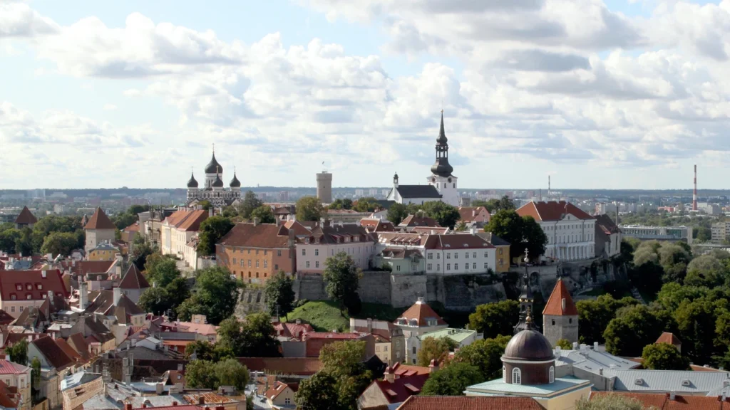
From the waterfront, Tallinn’s Old Town rises behind the harbour. That view explains why the city grew here, but the ridge and quays tell only part of the story: the municipal boundary extends around the bay and even includes a separate island.
Tallinn is Estonia’s capital, on Tallinn Bay on the south side of the Gulf of Finland. It is a Baltic port because the Gulf of Finland is an arm of the Baltic Sea. Toompea stands above the medieval Lower Town, while the modern Old City Harbour sits northeast of the historic centre.
How to use this article: Try the city boundary map, see the passenger and cargo harbours, or go to the two population definitions.
Tallinn’s coast and municipal limits
Read the bay, gulf and sea as nested waters
Tallinn faces a local inlet, Tallinn Bay, on the south shore of the Gulf of Finland. The gulf opens west into the Baltic proper. A harbour can therefore be accurately described as being on the Gulf of Finland and as a Baltic port. The first name gives a more precise location; the second describes the larger body of water.
The municipality is not limited to the Old Town and the bay immediately in front of it. Its land extends inland and along the shoreline. Aegna, across the water near the tip of the Viimsi Peninsula, is part of Tallinn’s Kesklinn district even though it is physically separate from Tallinn’s mainland. The nearby Viimsi municipality is not part of the capital.
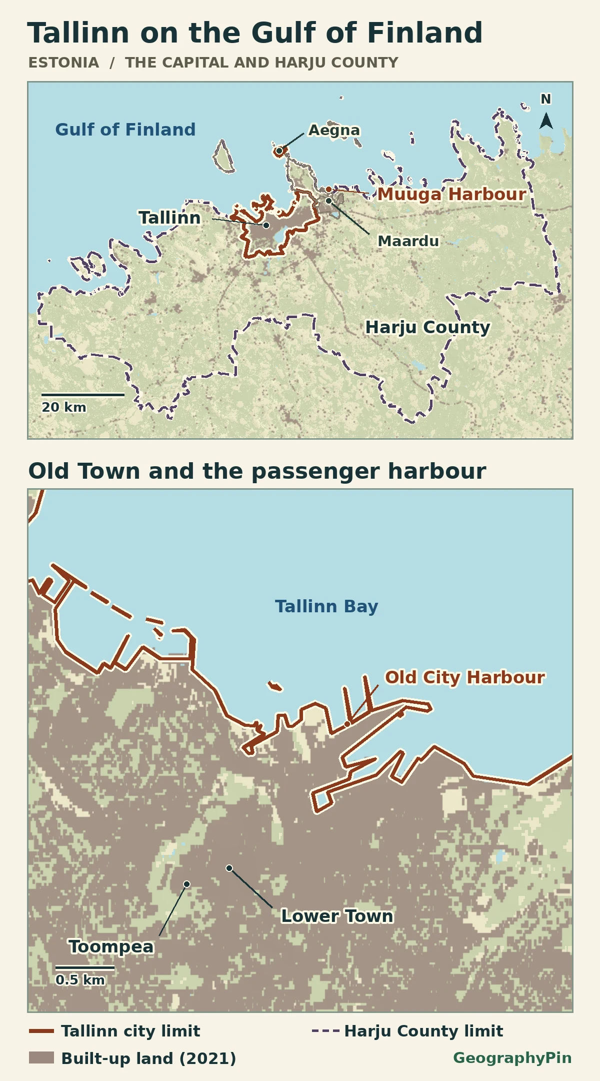
On the map, the dark built-up patches show land cover, not an administrative decision about where the city ends. The official land boundary is shown along the shoreline, including the outline around Aegna. The map does not assign nearby sea areas to municipal or port authorities.
Toompea and the streets below it
Use Vanalinn to locate the historic centre
Vanalinn is the Estonian name for the Old Town. It includes the upper town on Toompea and the lower streets around the Town Hall. Toompea alone is too narrow a label for the whole district; Kesklinn, the city’s central administrative district, is too broad.
Toompea’s limestone rise gives the upper town a distinct skyline. The castle and cathedral belong to this higher part of the historic centre. Below, the streets and plots of the medieval Lower Town grew around the activities of traders and craftspeople. The two levels are part of one preserved urban complex rather than separate cities.
UNESCO recognizes both levels in the Historic Centre (Old Town) of Tallinn. The picture taken from St. Olaf’s tower looks toward Toompea above the surrounding roofs. The atlas uses place pins for the historic areas rather than drawing an approximate World Heritage boundary.
The passenger harbour and the cargo coast
Follow the port name to the right quay
Old City Harbour lies northeast of the Old Town on Tallinn Bay. It is the Port of Tallinn’s main passenger harbour, with ferry terminals and cruise berths. Its name points to proximity, not an overlap with the medieval walled area: the passenger harbour is on the waterfront outside the historic core.
Port of Tallinn is also the name of the operator, which manages facilities beyond this downtown waterfront. Muuga Harbour, a principal cargo harbour, lies farther east in the wider Harju area, outside Tallinn municipality. The operator’s network also includes Paldiski South Harbour farther west. A shipping label and a place’s municipal address answer different questions.
Read the overview and closeup together. At county scale, the cargo facility sits beyond the capital’s outline; at street scale, the passenger harbour is close to Vanalinn but occupies a separate set of quays. Neither pin marks a legal port perimeter, sailing course, or specific check-in point.
The city population and the wider urban area
Compare the municipality and the county on the same date
Tallinn’s municipal statistics report 452,653 residents in the city at the beginning of 2026 based on Statistics Estonia’s population data. Harju County had about 645,000 residents on the same date; the municipal release puts Tallinn’s share of that total at about 70%. These are beginning-of-year resident statistics, not the result of a new population census.
| Area | Population | What it covers |
|---|---|---|
| Tallinn municipality | 452,653 | The capital within its city limits, including Aegna. |
| Harju County | About 645,000 | The city plus other municipalities. Statistics Estonia uses the county for Tallinn’s Urban Audit; this row is not a separately mapped commuter catchment. |
A functional urban area normally combines an urban core with its commuting zone. For Estonia’s Urban Audit, Statistics Estonia uses Harju County as Tallinn’s functional urban-area reporting unit. The dashed map boundary is the source county boundary, not a new line calculated from each person’s commute or the edge of the continuous built-up area. It includes separate municipalities such as Maardu, and the county number already includes Tallinn.
Frequently Asked Questions
Why is Tallinn a Baltic port if it is on the Gulf of Finland?
The Gulf of Finland is an arm of the Baltic Sea. Tallinn Bay on the gulf’s southern side is the more precise location of the downtown harbour.
How are Tallinn’s passenger harbour and historic centre positioned?
Old City Harbour sits northeast of the medieval centre on Tallinn Bay. They are close together, but the quays are not part of the walled Old Town.
Which name should I look for on a map of historic Tallinn?
Look for Vanalinn, the Old Town. Toompea is its higher part; Kesklinn is the wider city district.
What Did We Learn Today?
Tallinn Bay puts the capital on the Gulf of Finland and in the Baltic Sea system. The city has an inland historic rise, a nearby passenger harbour and a municipal boundary that reaches as far as Aegna. Harju County covers a wider area and includes the capital along with separate municipalities.
Sources & Data Notes
Administrative and settlement division units: Estonian Land and Spatial Development Board (Maa- ja Ruumiamet), validity November 1, 2026. Built-up and water: © ESA WorldCover project 2021 / Contains modified Copernicus Sentinel data (2021) processed by ESA WorldCover consortium (CC BY 4.0). Relief is from Mapzen Terrain Tiles, using Copernicus data and information funded by the European Union – EU-DEM layers. The map combines dated sources and is not a legal survey or current navigation map. Featured photograph: Gsitnikov, Toompea from St. Olaf’s tower, September 12, 2009, cropped and converted to WebP under CC BY 3.0.
- Estonian Land and Spatial Development Board: administrative and settlement division
- City of Tallinn: January 2026 population and share of Harju County
- Statistics Estonia RV0222U: January county population series
- Statistics Estonia: Harju County is the Tallinn functional-urban reporting unit
- UNESCO: the historic centre, Toompea and the Lower Town
- City of Tallinn: Kesklinn district, including Aegna
- Port authority: harbour locations
- Port authority: Old City Harbour
- Port authority: Muuga Harbour
- ESA WorldCover 10 m 2021 v200
- Mapzen Terrain Tiles, accessed November 21, 2026
- Gsitnikov: featured image source and licence