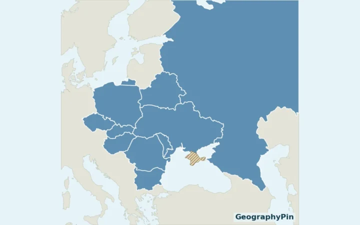
On a map of northwestern Romania, find Cluj-Napoca where development follows the Someșul Mic river between low hills. The historic centre sits inside the municipality, but the built-up valley does not end at the city line. That is why two valid census numbers can describe Cluj-Napoca and its metropolitan area.
Cluj-Napoca is the seat of Cluj County in Transylvania, in northwestern Romania. The Someșul Mic runs beside the historic centre and connects a broader developed corridor. In Romania’s 2021 census, the municipality had 286,598 residents; the 19-member Cluj Metropolitan Area association reports 420,839 on the same census basis.
How to use this article: Start with the municipal boundary, see Union Square and the hill across the river, then compare the 19-member population count.
1. Where the Municipality Ends and the County Continues
Find the municipal boundary
Look for Municipiul Cluj-Napoca on a Romanian administrative map. It means the municipality, the area inside the purple line below. Județul Cluj is Cluj County, a larger unit that contains the municipality, nearby communes such as Florești, and other towns and cities such as Turda and Dej. Cluj-Napoca is the county seat, not a shorter designation for the entire county.
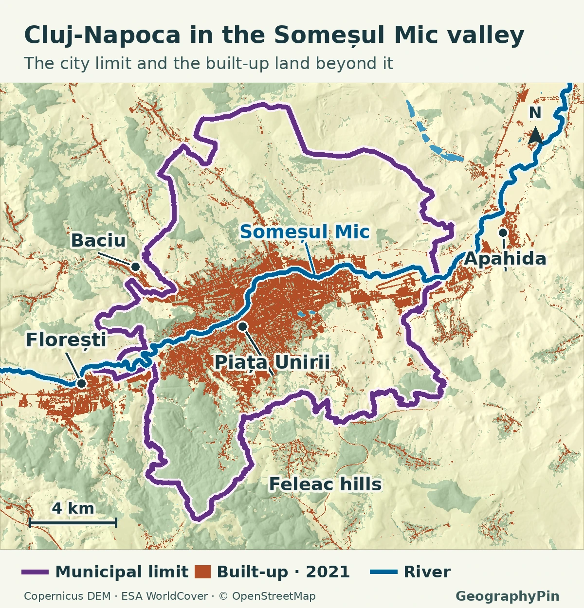
The purple line rises well beyond the orange along parts of the north and south. Toward Florești, look for the opposite pattern: development appears on both sides of the line. Those two patterns tell you why the boundary, building footprint and metropolitan membership need separate names. County and full metropolitan boundaries are not drawn here.
2. The River Valley and the Hills
Follow the Someșul Mic from the west: it runs past Florești, through Cluj-Napoca and onward toward Apahida to the east and northeast. Inside the municipality, the built-up strip often hugs the river’s lower ground. The Feleac hills to the south show why a straight-line distance across the city can mask slope and valley crossings.
The river is a better way to orient yourself than treating the city as a round dot on a country map. The west-to-east corridor links several settlements, while hills, green space and the river itself interrupt the developed land. The orange patches are a land-cover snapshot, not a continuous urban boundary traced around every street.
3. Finding the Historic Centre
Union Square and the hill across the river
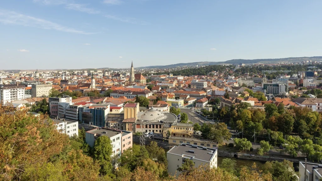
Use Piața Unirii (Union Square) and St. Michael’s Church to locate the historic centre. The square sits south of the Someșul Mic. Across the river, Cetățuia rises above the north bank, giving the view toward the old city shown in the photograph.
That bank-to-bank contrast makes the city easier to read. Piața Unirii is a landmark within the old street pattern; Cetățuia is a hill overlooking it. Neither denotes a separate census unit. The city’s riverside planning documents treat the bridges between the two banks as connections between parts of one city.
4. From Florești to Apahida: The Metropolitan Fringe
At the western end, follow the national road DN1 toward Florești. The commune’s own census tables include residents of Florești village, Luna de Sus and Tăuți. Those residents do not become Cluj-Napoca municipal residents just because buildings crowd up to the city limit.
Baciu sits northwest of the centre and Apahida lies farther along the valley to the east. Both are separate communes and members of the same metropolitan association. An association brings together local governments for shared planning; it can include agricultural land and villages beyond the streets you might think of as the city.
5. What the 2021 Population Figures Count
What the 19-member count includes
The figures below report residents on the same census date, December 1, 2021. The metropolitan total uses the association’s stated 19-member roster, not a satellite threshold or a commuting model.
| Area counted | Residents | What it includes |
|---|---|---|
| Cluj-Napoca municipality | 286,598 | Municipality only |
| Cluj Metropolitan Area association | 420,839 | Cluj-Napoca plus 18 communes |
| Florești commune | 52,735 | Three villages; already included in the association total |
Subtract the municipality from the association total and you get 134,241 residents in the other 18 members, about 32% of the reported total. That is a real difference in the same census, not a count of suburban commuters or of everyone under the orange land-cover layer. Eurostat defines a functional urban area by adding a commuting zone to a city identified from local units around a dense urban centre. Use a figure under that definition only when its boundary and reference year are specified.
Frequently Asked Questions
How can I tell Cluj County from the city on an official map?
Look for Județul Cluj for the county and Municipiul Cluj-Napoca for the city municipality. A county map covers many local governments, including Cluj-Napoca and neighboring communes.
Which river runs through central Cluj-Napoca?
The Someșul Mic runs beside the historic centre, north of Piața Unirii. It also runs through the wider valley toward Apahida.
Is Florești included in the 420,839 figure?
Yes. The association’s 19-member total for the December 1, 2021 census already includes Florești’s 52,735 residents. Do not add the commune again.
What Did We Learn Today?
Cluj-Napoca’s historic centre sits on the south side of the Someșul Mic, and the developed valley continues beyond the city line. The municipality is just one part of Cluj County and one of 19 members of the metropolitan association. Use those names to compare like-for-like population figures.
Sources & Data Notes
- Cluj Metropolitan Area association: membership and final census figures. The 19 published member totals sum to 420,839, including 286,598 in Cluj-Napoca and 52,735 in Florești. See Romania’s National Institute of Statistics 2021 census documentation, resident population tables, and Florești commune’s statute, census table, for the village and commune levels. These are fixed-date counts, not annual estimates.
- Municipality’s geographic description and municipal Someșul Mic riverfront planning notes, for the physical setting and the link between Piața Unirii and Cetățuia. The Cluj integrated urban development strategy identifies the Florești DN1 corridor; no planned route is shown as open.
- Eurostat methodology for cities and functional urban areas, for the separate commuting definition. No Eurostat headcount is mixed into this comparison.
- Original GeographyPin map in UTM 34N. The city line is from OpenStreetMap relation 3277038, version 24 (October 15, 2026); the river from relation 6156396, version 13 (December 20, 2023). © OpenStreetMap contributors, ODbL. Orange shows the built-up class of ESA WorldCover 2021 v200, CC BY 4.0, clipped, reprojected and styled. This is an orientation map, not a cadastral or metropolitan-boundary survey.
- Produced using Copernicus WorldDEM-30 © DLR e.V. 2010-2014 and © Airbus Defence and Space GmbH 2014-2018 provided under COPERNICUS by the European Union and ESA; all rights reserved. Copernicus GLO-30 terms. The organisations in charge of the Copernicus programme by law or by delegation do not incur any liability for any use of the WorldDEM-30.
- Photograph: “Cluj panorama 2026” by Yerpo (Jernej Polajnar), September 17, 2026; cropped, resized and converted to WebP. This adaptation is licensed CC BY-SA 4.0.