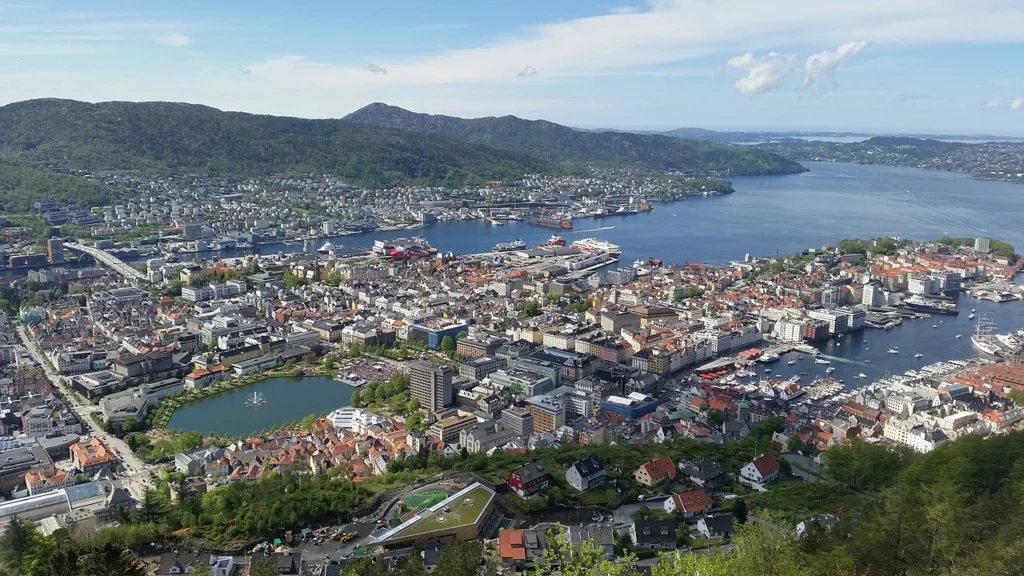
On a map of western Norway, Bergen may look like a coastal dot. Zoom in and the city is tucked beside a sheltered harbour, with islands toward the sea and mountains between several of its neighbourhoods.
Bergen lies in Vestland, on Norway’s west coast. Its historic centre grew around Vågen, an inlet opening into Byfjorden. The city extends behind the harbour hills to areas such as Arna and Fana. Statistics Norway counted 294,860 residents in Bergen municipality and 274,589 in its named built-up settlement on 1 January 2026.
How to use this article: Start with the fjord and harbour map, see what lies beyond the mountains, then compare what the two population figures count.
Reading Bergen’s map from sea to city
Find the fjord and harbour
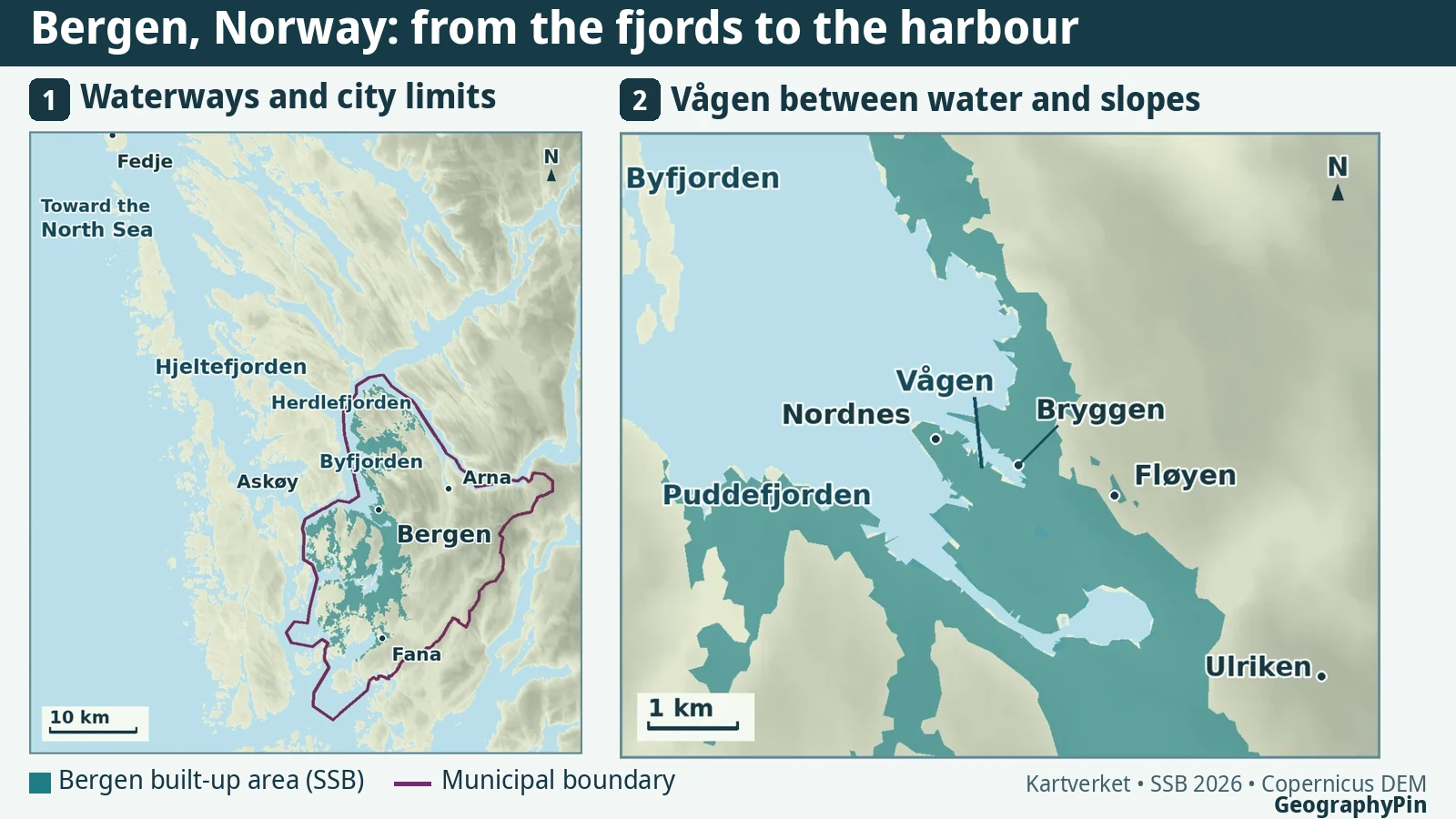
Bergen sits inside a network of coastal islands and fjords, rather than on a beach facing the open North Sea. Start with the upper map: the islands west and north of the city are broken by long waterways, including Hjeltefjorden and Herdlefjorden. Nearer town, Byfjorden separates the Bergen side from Askøy. Askøy is across the water and has its own municipality, rather than being an island district of Bergen.
The lower map changes scale. Here, the waterway to look for is Vågen: the smaller inlet opening from Byfjorden, not the whole stretch of water beside town. Nordnes divides Vågen from Puddefjorden, a separate inlet on the peninsula’s southwest side. These two cuts in the shoreline explain why central Bergen has several waterfronts, even though Bryggen is the one most people recognise.
How Vågen shaped the old town
Vågen gave cargo a place to come ashore inside the fjords. The Hanseatic merchants at Bryggen, on its northeastern waterfront, used their position to trade stockfish, or dried fish, from northern Norway. A shipment could arrive by water, go into storage and be sold onward without first being carried far inland. That connection between the quay and the buildings behind it helps explain why both are important to the story of this port.
The wooden rows at Bryggen preserve an old building pattern, not an untouched row of medieval houses. Fires led to repeated rebuilding. UNESCO recognises the surviving harbour district for the urban layout and building traditions that those reconstructions preserved. On the lower map, Bryggen marks one shore of Vågen: the city developed on more than that single strip.
What lies on the other side of the mountains?
What lies beyond the mountains
From Fløyen, the old port looks close enough to fit in a single view. North and east of the harbour, however, ridges separate parts of the municipality that are close on a plan map. Bergen’s own mountain guide describes the central uplands as a divide between the centre to the west, Åsane to the north, Arna to the east and Fana to the south.
Find Arna in the upper panel and you are already on the other side of the high ground from the historic waterfront, without leaving Bergen. The broad teal pattern south of the centre tells a different story: development there spreads away from the harbour toward other valleys and shorelines. On the close-up map, Fløyen is the overlook above the old centre and Ulriken is a separate mountain farther southeast. Ulriken rises to 643 metres in the municipality’s mountain guide. The compact port and the much larger city are both real; they are just visible at different scales.
Why Bergen has two population figures
What the two population figures count
Statistics Norway uses a legal boundary to count residents of Bergen municipality and a separate built-up boundary to count residents of the Bergen urban settlement. That settlement, called a tettsted in Norwegian, is defined by how closely buildings are grouped, with rules for spaces such as parks. It is not drawn from commuting patterns.
The lower count follows Statistics Norway’s named Bergen settlement, based on where buildings cluster. The municipal count also includes residents of other settlements and rural places within its legal limits.
| Area | Residents | What is counted |
|---|---|---|
| Bergen municipality | 294,860 | Everyone registered inside the administrative boundary |
| Bergen urban settlement | 274,589 | Residents of the named 90.70 km² built-up settlement |
The named urban settlement is entirely inside the municipality. The two same-date figures therefore leave 20,271 residents elsewhere in the municipality. That does not mean all 20,271 live in the countryside: separate settlements can also fall outside the named Bergen footprint. It also does not tell us how many people live on an adjoining island and commute into the city.
Frequently Asked Questions
Are there exactly seven mountains around Bergen?
No. The municipality says lists of the traditional seven vary. The annual seven-mountain hike uses a specific set, while Bergen’s broader city-mountain area includes other peaks and ridges.
What’s the difference between Fløyen and Fløyfjellet?
Fløyen is the name used for the viewpoint above the city centre. Fløyfjellet is the mountain identified on the municipality’s seven-mountain itinerary, where it is listed at 400 metres. The height of the mountain is not the height of the viewpoint.
What Did We Learn Today?
Bergen’s old trading waterfront grew beside a protected inlet, but the city extends well beyond that one harbour. Reading the fjords, slopes and population boundaries separately explains how a compact historic centre can sit inside a much larger municipality.
Sources & Data Notes
The two population figures use the same reference date. Teal on the map shows the statistical boundary, not a commuter catchment or all developed land in the municipality.
- Statistics Norway: city and municipality figures and population and land area in urban settlements, Tables 1 and 2, reference date 1 January 2026. The 20,271 figure is the difference between the two official counts, not a published rural population total.
- UNESCO World Heritage Centre: Bryggen, for the warehouses, stockfish trade and historical rebuilding; Bergen municipality’s harbour documentation, for Vågen.
- Kartverket: coastal sailing directions, place-name data and Bergen municipality boundary. Bergen municipality: city mountains and Fløyen.
- Original map by GeographyPin. Teal traces Statistics Norway’s Tettsteder 2026 (NLOD 1.0), generalised for legibility. Contains modified Copernicus DEM data (accessed 2026); the relief and simplified coast are for orientation, not navigation.
- Featured photograph: Slumptreff, Bergen city centre (2017), CC BY-SA 4.0; resized and converted to WebP.