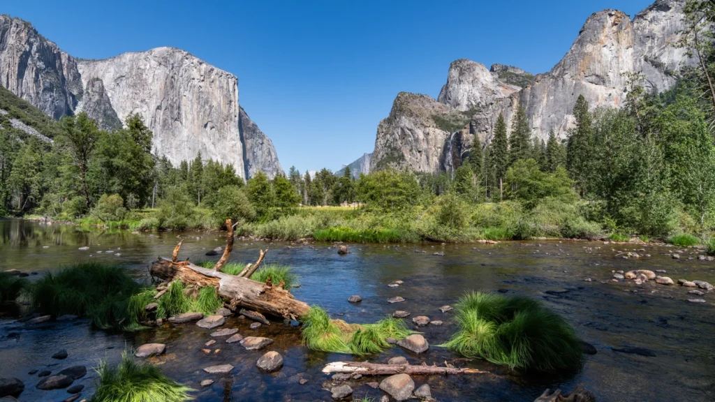
A Yosemite Valley map is easier to use once you know which road carries you in and which takes you out. A viewpoint across the Merced River may be close in a straight line but require a different driving leg or a walk from a different parking area.
Which side of Yosemite Valley should you stop on?
Use Southside Drive for the main eastbound trip into Yosemite Valley and Northside Drive for the westbound return. Save El Capitan Meadow and Valley View for the way out.
Tunnel View is above the valley floor on Wawona Road, while eastern stops are easier to combine on foot or by shuttle.
How to use this article: Choose a car or shuttle plan, save two viewpoints for the westbound drive, or check which access details may change after snow or roadwork.
Choose your approach to the valley
Choose the park entrance before choosing viewpoints. The regular west-side approaches are Highway 140 through Arch Rock from El Portal, Highway 120 west through Big Oak Flat, and Highway 41 through the South Entrance and Wawona. The first two reach the valley from El Portal Road; Highway 41 reaches it via Wawona Road. Tioga Pass on Highway 120 east is an entrance to the high country, not a direct road into the valley from its east end.
Choose a car or shuttle plan first
| If you are… | Good first decision | What to check |
|---|---|---|
| Driving for viewpoints on both sides | Use the eastbound road for south-side stops, then leave by the north-side road for El Capitan Meadow and Valley View. | Tunnel View is a separate stop on Wawona Road. Use designated parking and follow traffic directions. |
| Parking once or arriving by bus | Choose Yosemite Village for central walks or Curry Village for easier access to the eastern end, then use paths or the shuttle. | YARTS is the bus into the valley; the NPS valley shuttle is separate. The Valleywide route covers more of the valley than East Valley. |
YARTS lists Highway 140 buses from Merced and Mariposa into Yosemite Valley. Check the return trip and holiday exceptions before you rely on one. The park’s parking advice favors staying in your first legal space and walking or taking the shuttle; space is not guaranteed at later stops.
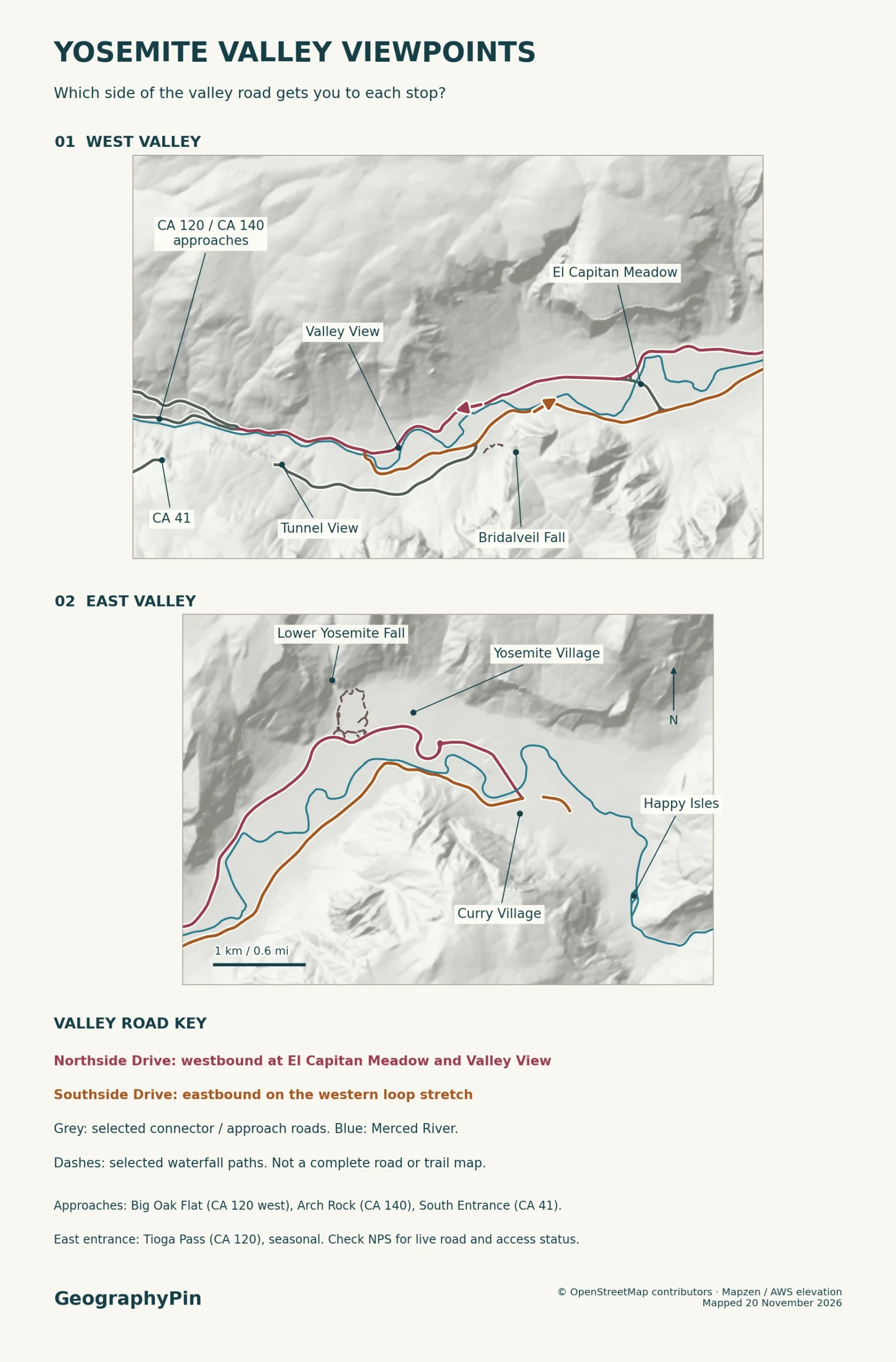
How the one-way valley roads work
The Merced River runs between the two main valley-floor roads. Southside Drive is one way eastbound as you enter the valley. Northside Drive carries traffic west on the main outbound stretch, but the National Park Service describes it as primarily one way, not one rule for every eastern junction. Check local signs for connections and turns.
Bridalveil Fall works well on the way in. The National Park Service measures the trail from its dedicated parking area at 0.5 mile (0.8 km) round trip. That is a walk to the waterfall, not the distance from the valley entrance or from Tunnel View. Farther east, Cathedral Beach and the Swinging Bridge picnic area are south-side river stops on the inbound drive.
Tunnel View sits at the east portal of the Wawona Tunnel on Highway 41, above the floor. It faces along the valley toward El Capitan, Bridalveil Fall and Half Dome. If you enter on Highway 120 west or 140, the roadway does not take you past that viewpoint automatically. Plan the separate Wawona Road leg when conditions allow.
El Capitan Meadow and the outbound stops
Save El Capitan Meadow and Valley View for the way out
El Capitan Meadow is beside Northside Drive near El Capitan Bridge. It gives an upward view of El Capitan and a view across to Cathedral Rocks. El Capitan Picnic Area and El Capitan Meadow are separate marked locations. If you are taking the bus, check the latest Valleywide shuttle stop information rather than assuming the East Valley route reaches this part of the floor.
Valley View is farther west on Northside Drive, just before Pohono Bridge on the way out. It faces up the valley at river level; look for El Capitan and Bridalveil Fall across the Merced.
On the way out: use westbound Northside Drive for El Capitan Meadow, then Valley View before Pohono Bridge. If you pass Valley View, continue to the exit or follow posted directions for another loop; don’t turn into the one-way lane. Tunnel View is a separate stop on Wawona Road, not the next pullout on Northside Drive.
Eastern valley stops after you park
Yosemite Village, near the Welcome Center and a main parking area, is a useful eastern-valley base. The paved Lower Yosemite Fall trail is a 1-mile (1.6-km) loop from its trailhead, distinct from the longer hike to the top of Yosemite Falls. On an afternoon with firm plans elsewhere, the lower loop is the shorter walk to budget for.
At Sentinel Bridge, the view looks along the river toward Half Dome. The National Park Service’s Cook’s Meadow Loop is another 1 mile (1.6 km) and offers a way to combine that view with views of Yosemite Falls. Sentinel Bridge is not El Capitan Bridge farther west.
Use Curry Village and the shuttle or walking paths to reach Happy Isles and the Mirror Lake area. The park’s access rules restrict the final Happy Isles Road segment and Mirror Lake Road to shuttles, vehicles with disability placards, walkers and bicycles. An apparent road on the map is not ordinary public parking at the trailhead.
What changes when a road or trail closes
Use current conditions for road status, not a static map
A closure can change the entire approach or only one connection. If Tioga Road is closed, you cannot cross the park by car from the east. If Glacier Point Road is closed, that blocks the drive to the rim viewpoint but does not by itself close the valley floor or Tunnel View. If a west-side approach closes, check the remaining approaches before committing to a detour.
National Park Service check, November 20, 2026: the road-status table listed east-side Tioga Road and Glacier Point Road closed for the season and west-side Big Oak Flat Road temporarily closed due to snow. NPS also listed weekday pedestrian closures at El Capitan Bridge through December 2026, with limited weekend access. Vehicle delays and possible brief closures are separate from the trail restriction. The bridge closure can disrupt the walking half-loop across the Merced; it is not a closure of every nearby viewpoint.
Before setting out, check the NPS current conditions and call the park’s road line at 209-372-0200 (press 1, then 1) for its latest road message. Check the approach highway as well as the local valley roads. Signs, closures and chain controls take precedence over any stored map.
Frequently Asked Questions
Which viewpoint should I save for the drive out of Yosemite Valley?
Save Valley View for the westbound Northside Drive, after El Capitan Meadow and before Pohono Bridge. The National Park Service identifies it as a view from the parking area, which has designated accessible spaces. It is not a stop on the inbound Southside Drive.
Can I use the official map without cell service?
Yes. Download Yosemite for offline use in the NPS app before leaving a reliable connection. The saved map is useful for orientation, but it will not tell you about a new closure unless you refresh your information before setting out.
Does a park entrance reservation replace trail or lodging reservations?
No. NPS announced that Yosemite would not use timed park entrance reservations in 2026. That does not cancel separate booking or permit requirements for lodging, campgrounds or certain hikes. Check the entrance policy for the year of your visit.
What Did We Learn Today?
Choose the approach first, take the eastbound road for south-side stops, and save El Capitan Meadow and Valley View for the main westbound drive. Tunnel View is a separate Wawona Road stop. Park once for the eastern cluster if you can, and use current road and trail notices rather than assuming the whole map is accessible.
Sources & Data Notes
Use the National Park Service park and valley maps, official valley viewpoint descriptions and NPS access and traffic guidance for the road and viewpoint layout, and YARTS Highway 140 service and NPS shuttle information for bus and shuttle service. Walking distances follow NPS trail descriptions for Bridalveil Fall Trail, Lower Yosemite Fall Trail and Cook’s Meadow Loop from their stated starting points. See the NPS Superintendent’s Compendium, current conditions and El Capitan Bridge and the Valley Loop Trail for road and trail restrictions; check Valley View accessibility details, the NPS app and the entrance reservations policy for specific trip needs. Opening Valley View photograph: © Steffen Schmitz (Carschten) / Wikimedia Commons / CC BY-SA 4.0; cropped and converted to WebP under the same license. Editorial responsibility: Zurab Koniashvili (Z.K. Atlas); AI tools assisted in preparation.

Map: GeographyPin; road, trail and viewpoint geometry from OpenStreetMap contributors (ODbL) and relief from Mapzen/AWS. This is not a complete trail network, park boundary or road access report.