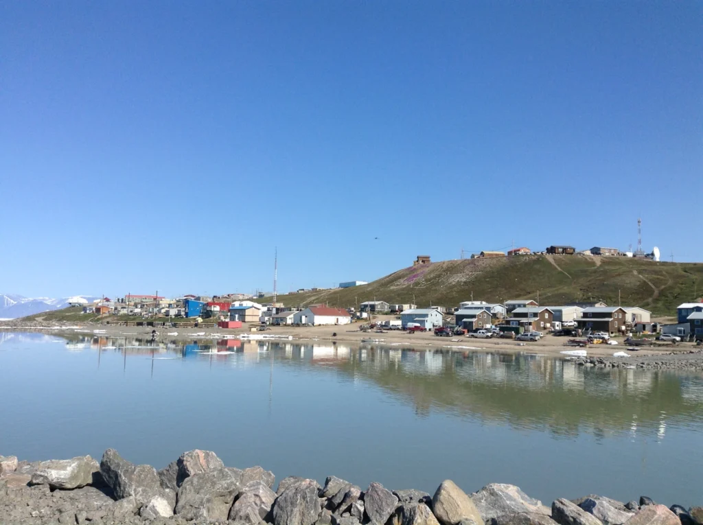
Pond Inlet, known as Mittimatalik in Inuktitut, is an Inuit community on northern Baffin Island in Nunavut, Canada. Its shoreline faces Arctic waters and the mountains of Bylot Island. Understanding the place starts with separating the community from the nearby marine inlet that shares its English name.
Mittimatalik, an Inuit community, stands on the south shore of Eclipse Sound. Pond Inlet also names a marine waterway between Baffin and Bylot islands. The settlement, surrounding waters and wider land-use region are related, but they are not the same geographic unit.
How to use this article: Start with the Arctic setting, distinguish the place names, or examine the dated sea-ice evidence.
1. Where Is Pond Inlet?
Northern Baffin Island, across from Bylot Island
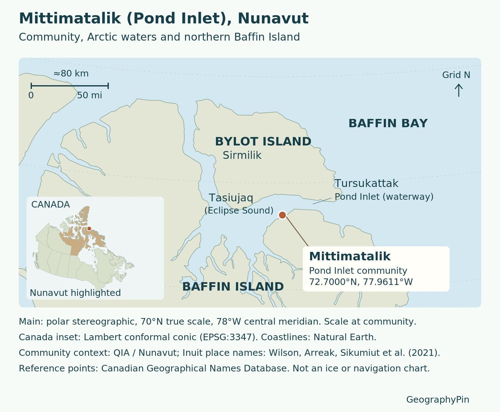
Mittimatalik is in Nunavut’s Qikiqtaaluk Region, in the eastern Canadian Arctic. The Government of Nunavut locates it on the southern shore of Eclipse Sound, facing Bylot Island’s mountains. On a national map, look well north of mainland Canada, toward the northeastern side of Baffin Island.
The official Canadian geographical-names record places the hamlet reference point at approximately 72.7° N, 77.96° W. This is a useful map locator, not a boundary for the community or its surrounding harvesting areas.
The mountain backdrop matters for orientation: Bylot Island is across the water, while the community itself is on Baffin Island. The Hamlet’s history also identifies Mount Herodier near the eastern end of Eclipse Sound. A distant mountain visible from the waterfront therefore need not stand on the same island as the observer.
The original map below uses an Arctic projection and a separate Canada inset. Read the main scale bar for regional distances; the inset is only a national locator.
2. One English Name, Different Geographic Features
Settlement, waterway and wider region
| Name | What it identifies | How to read it |
|---|---|---|
| Mittimatalik / Pond Inlet | The community | A settlement on Baffin Island |
| Tasiujaq / Eclipse Sound | Marine waters beside the community | A surrounding water body, not a municipal boundary |
| Tursukattak / Pond Inlet | The marine inlet | A waterway, not a freshwater pond |
| Sirmilik / Bylot Island | The island across the water | Distinct from Baffin Island |
The Inuit place-name pairings above follow the Inuit-coauthored 2021 Mittimatalik Sea Ice Climate Atlas study. The Qikiqtani Inuit Association also explains that the hamlet shares its English name with the arm of sea separating Bylot and Baffin islands.
“The Pond Inlet region” can describe a broader area of waters, coasts and land used by residents. Its extent depends on the map or study. A marine research boundary, a community census boundary and an area of Inuit land use answer different questions; none should silently substitute for another.
3. An Inuit Community Connected to Land and Sea
The Qikiqtani Inuit Association identifies residents as Tununirmiut or Mittimatalingmiut, the latter meaning people of Mittimatalik. Its community account places land, sea and ice within a long history of Inuit life, rather than treating the surrounding country as empty scenery.
The 2018 Nunavut Coastal Resource Inventory documents that relationship through fieldwork conducted in February 2016. Ten interviews with elders and hunters gathered knowledge of coastal and aquatic resources. Participants’ mapped observations were incorporated into a geographic information system, bringing place-based knowledge into a form useful for resource management.
This method matters: a coastline map shows where land meets water, but interviews can explain how places are used and how seasonal conditions affect them. The inventory combines historical and then-contemporary knowledge; it is not a live wildlife distribution map.
Mittimatalik is also a present-day community with institutions and changing needs. QIA describes the Pirurvik preschool, established in 2016, as an example of Inuit knowledge informing education. Geography here includes the relationships through which people learn, work and use their surroundings, not only the outlines of islands.
4. Sea Ice: A Seasonal Landscape, Not a Fixed Calendar
What the 1997–2019 record tells us
The 2021 Sea Ice Climate Atlas study examined a 1997–2019 record, combining Inuit knowledge, satellite observations and Canadian Ice Service charts. It documents variable autumn-to-early-winter freeze-up and summer breakup.
Regional breakup was earliest in 2019 and latest in 2005 within that record. No significant trend emerged in weekly landfast-ice formation. Different ice processes need separate interpretation.
Tuvaq refers to landfast ice; the sinaa, or floe edge, marks its boundary with open water. Its changing position is not a permanent coastline.
SmartICE’s Mittimatalik resources describe maps and learning materials developed with the local Sikumiut committee. They bring Inuit sea-ice knowledge into explanations of travel conditions and seasonal change. The historical atlas supports understanding; it does not establish whether a route is safe today.
5. Population and Present-Day Orientation
The Nunavut Bureau of Statistics’ December 2025 fact sheets report 1,555 people for Pond Inlet in the 2021 census. This count describes the community, not everyone using the wider marine region, and it is not a November 2026 population estimate.
The booklet’s publication date should not be mistaken for the year its population was counted.
For practical orientation, consult the Hamlet’s own information and the community guidelines, checked for this article on November 17, 2026. The guidelines ask visitors to respect homes and belongings and seek permission before photographing people or their homes. Neither the locator map nor the historical sea-ice discussion is a current transport or ice-safety advisory.
Frequently Asked Questions
What does Mittimatalik mean?
The community guidelines acknowledge two interpretations: a landing place associated with birds, and the place where Mittima is buried. The Hamlet’s history emphasizes the landing-place interpretation. It is better to recognize these differing accounts than present one translation as settled.
Was Pond Inlet named after a pond?
No. The Hamlet’s history traces the English name Pond’s Bay to John Ross’s 1818 naming in honor of John Pond, then Britain’s Astronomer Royal. The word Pond in this place name is not a classification of the surrounding sea.
What Did We Learn Today?
Pond Inlet’s geography becomes clearer when the community, marine inlet and wider region are read separately. Inuit names and knowledge give meaning to the mapped coast, while dated population and sea-ice evidence explain their own particular periods rather than today’s conditions.
Sources & Data Notes
Population is the 2021 community count reproduced in the December 2025 fact sheets. The 2018 coastal inventory draws on February 2016 interviews; the 2021 ice study analyzes 1997–2019. Coordinates are rounded from the official hamlet record. These sources provide geographic and historical context, not current ice conditions.
- Government of Nunavut: Pond Inlet
- Hamlet of Pond Inlet: History
- Qikiqtani Inuit Association: Communities, Mittimatalik
- Natural Resources Canada: Pond Inlet hamlet record
- Wilson, Arreak, Sikumiut Committee and colleagues (2021): Mittimatalik Sea Ice Climate Atlas
- SmartICE: Mittimatalik Inuit sea-ice knowledge resources
- Nunavut Coastal Resource Inventory: Pond Inlet (2018)
- Nunavut Bureau of Statistics: December 2025 fact sheets, Pond Inlet p. 24
- Pond Inlet community guidelines, hosted by AECO
Photograph: Mittimatalik (Pond Inlet), July 16, 2022. Emilijak Knezevic / Wikimedia Commons, CC BY-SA 4.0; resized and converted to WebP.