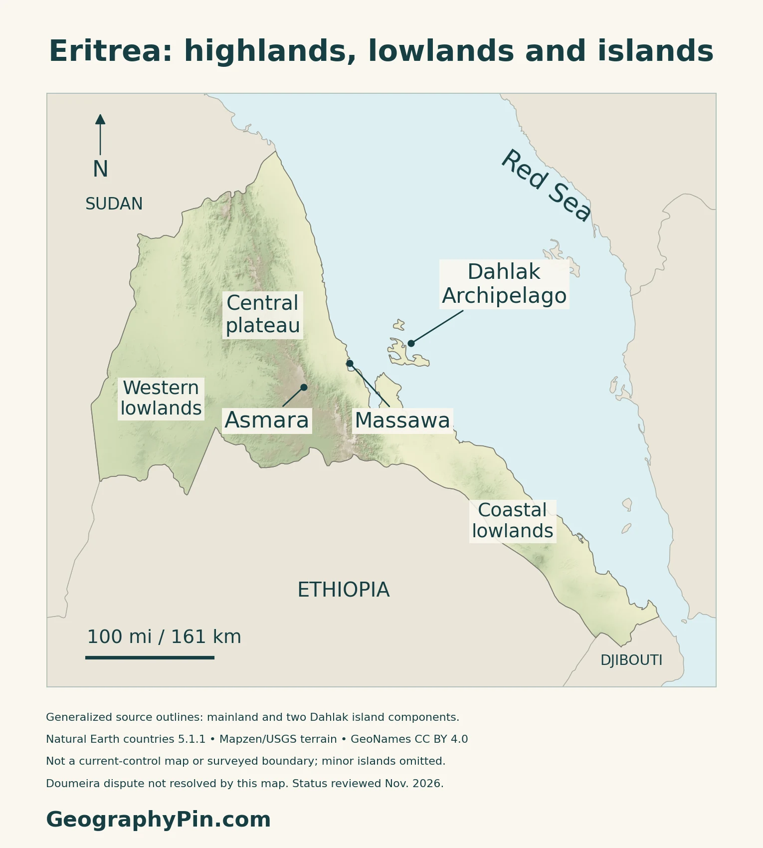
Asmara and Massawa illustrate Eritrea’s sharp change in elevation: the capital stands on the central plateau, while the port faces the Red Sea below the eastern escarpment. West of the highlands lies another lowland landscape, and offshore the Dahlak islands add a marine dimension to the country’s geography.
Eritrea is an independent country in the Horn of Africa, bordering Sudan, Ethiopia and Djibouti along the western side of the Red Sea. Its capital is Asmara. Central highlands separate western lowlands from the hotter eastern coastal plain, while the Dahlak Archipelago lies offshore. Elevation, seasonal rainfall and drainage help explain differences in farming, water supplies and settlement.
How to use this article: Locate the country on the map, read the physical map, explore rainfall seasons, or check the population reference.
1. Locate Eritrea on the Red Sea
A separate state on the Red Sea
Eritrea lies in the Horn of Africa, along the western shore of the Red Sea. Sudan borders it to the west and northwest, Ethiopia to the south, and Djibouti to the southeast. Offshore islands, including the Dahlak Archipelago, form part of its coastal geography.
Eritrea is a sovereign state separate from Ethiopia. It became independent in 1993 and joined the United Nations on May 28 that year. The two countries’ 2018 rapprochement should not be read as proof that every border detail on a generalized map represents a newly surveyed or fully implemented boundary.
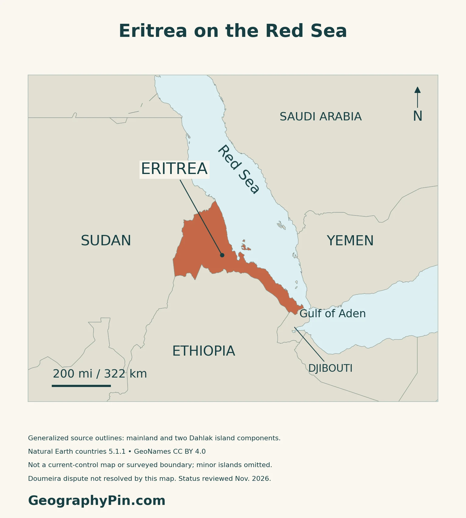
Asmara is inland, above the coastal lowlands
Asmara is Eritrea’s capital in the central highlands. Massawa, on the Red Sea coast, is a different city with a port setting. Their contrasting positions help explain why the national capital and a major maritime gateway have different landscapes and climates.
2. Compare the Highlands, Lowlands and Islands
The central plateau is not the whole country
| Setting | Physical character | Map reference |
|---|---|---|
| Central highlands | Dissected plateaus and valleys | Asmara lies on elevated ground |
| Eastern escarpment and coast | A steep descent toward hot lowlands | Massawa faces the Red Sea |
| Western lowlands | Lower terrain west of the highlands | Seasonal drainage extends toward Sudan |
| Dahlak Archipelago | Offshore islands and shallow marine habitats | Island group east of Massawa |
The eastern descent is especially abrupt
The central highlands are cut by valleys. Their eastern edge descends steeply toward the coastal plain, while lower terrain and river valleys extend west toward Sudan.
Dahlak adds reef and island landscapes
Eritrea’s 2015 biodiversity strategy describes the Dahlak Archipelago as remnants of older reef platforms modified by tectonic movement and erosion. These platforms support modern reefs amid shoals, sandbanks and deeper channels. They are not an offshore continuation of the high central plateau.
The same strategy records coral, seagrass and mangrove habitats along the country’s marine margin.
3. Follow Seasonal Rain and Water
Highland summer rain differs from coastal winter rain
Eritrea’s December 2021 Third National Communication describes summer rains, broadly June through September, in the highlands and western lowlands. Eastern lowlands receive their rain mainly in the cooler part of the year. The report gives October–March in its detailed account, with a shorter November–February period in its summary.
The eastern escarpment also includes a wetter belt with two rainfall seasons. Elevation and exposure therefore matter alongside the calendar: a national rainy-season label cannot describe every slope and coastal locality. Rainfall varies substantially between years and across short distances.
Seasonal channels and a perennial border river
Many Eritrean river channels carry water seasonally. The FAO’s 2005 AQUASTAT profile identifies the Setit, also known upstream as the Tekezé, as the perennial river along part of the Ethiopian border. It distinguishes drainage toward the Red Sea from the closed Danakil basin, where water does not flow onward to an ocean.
The British Geological Survey explains why low annual rainfall can coexist with flash floods: intense, short-lived rain can send water through channels without sustaining year-round flow. Groundwater is important for supplies.
4. Connect Cities, Farms and the Coast
Asmara’s plateau setting and built landscape
UNESCO describes Asmara at more than 6,560 feet (2,000 meters) above sea level. The World Heritage property, inscribed in 2017, includes planned streets and modernist buildings developed during Italian colonial occupation, together with indigenous neighborhoods.
Rainfall timing matters to crops and grazing
FAO’s September 30, 2026 crop brief identifies wheat, barley, sorghum, maize, teff and pulses in the main cropping season. It describes planting in central and western regions and names Gash Barka as a major crop-producing area. Its warning about dry conditions concerned the 2026 season, not a permanent measure of agricultural productivity.
Different farming systems use water differently. The 2005 AQUASTAT profile distinguishes highland rainfed cultivation, lowland spate irrigation and pastoral or agro-pastoral systems.
Massawa and the shore have different roles from Asmara
Massawa is a port on the Red Sea, with the Dahlak islands offshore. A Ministry of Information account of the northern coast describes communities combining fishing, livestock keeping and trade. It also identifies mangroves and seagrass around parts of the coast and islands, habitats that connect sheltered shorelines with marine life.
For the wider sea’s bordering countries and connections, see the Red Sea map.
5. Dated Country Facts and Institutions
| Item | Reference | Date or scope |
|---|---|---|
| Capital | Asmara | Central highlands |
| Population | About 3.607 million | UN projected estimate, 2025; medium-fertility variant |
| Surface area | About 46,774 sq mi (121,144 km²) | UN reference, 2023; not land-only |
| Languages | Tigrinya, Arabic and English have important public roles | Not an official-language designation |
| Currency | Nakfa (ERN) | National currency |
| Government | Presidential government under the PFDJ | Current institutional context; see note below |
| Administration | Six regions (zobas) | Confirmed in a 2026 national-government publication |
Population estimates need a reference year
The table uses UNData’s 2025 medium-fertility projected estimate, not a newly enumerated census total. Eritrea’s National Statistics Office separately describes its national estimation series in metadata submitted to the UN for 2025: that series was produced in April 2022 using a 2002 population quick count and demographic surveys. Published population estimates vary substantially; the figure here identifies its source and year rather than treating different series as interchangeable.
Language use is not the same as legal status
The UK’s Permanent Committee on Geographical Names reports no designated official languages, while describing widespread roles for Tigrinya, Arabic and English. Other Eritrean languages include Tigre, Afar, Saho, Bilen, Bedawiyet, Kunama and Nara.
The Constitution ratified in 1997 contains an equality-of-languages provision, but its institutional framework has not been implemented. UNHCR’s April 2026 guidance describes PFDJ rule and suspended constitutional institutions. The constitutional text should therefore not be presented as a description of a functioning elected parliamentary system.
What Did We Learn Today?
Eritrea’s geography brings together a high central plateau, lower western terrain, a hot Red Sea coast and offshore islands. Asmara and Massawa occupy contrasting settings. Rainfall seasons differ across the country, and seasonal streams, groundwater, cultivation and coastal livelihoods connect people with different parts of this landscape.
Sources & Data Notes
Population and surface area retain their stated statistical years and definitions. Historical forestry and water reports support stable landforms and farming systems, not current population, dam counts or economic shares. The climate account comes from the December 2021 national communication; coastal rainy-season dates vary within that report. Biodiversity observations are from the 2015 strategy. FAO’s September 2026 crop warning was seasonal and did not report a final harvest. Asmara’s World Heritage inscription covers a defined property.
- UNData: 2025 projected population, 2023 surface area, capital, currency and UN membership
- Eritrea National Statistics Office: population-estimate methodology submitted to UN Statistics, reporting year 2025
- UK PCGN: Eritrea names, languages and administrative geography
- UNHCR: Guidance Note on Eritrea, April 2026
- 1997 Constitution, Article 4; text distinguished from current implementation
- Eritrea Ministry of Information: six administrative regions, August 3, 2026
- FAO Forestry Outlook Study: Eritrea, stable landscape description (historical report)
- Eritrea Ministry of Land, Water and Environment: biodiversity strategy (November 2015)
- Eritrea: Third National Communication to UNFCCC (December 2021)
- FAO AQUASTAT: Eritrea water and farming profile (2005)
- British Geological Survey: Hydrogeology of Eritrea (2018 compilation)
- UNESCO: Asmara, a Modernist African City; inscribed 2017
- FAO GIEWS: Eritrea crop brief (September 30, 2026)
- Eritrea Ministry of Information: coastal resources and livelihoods (June 2018)
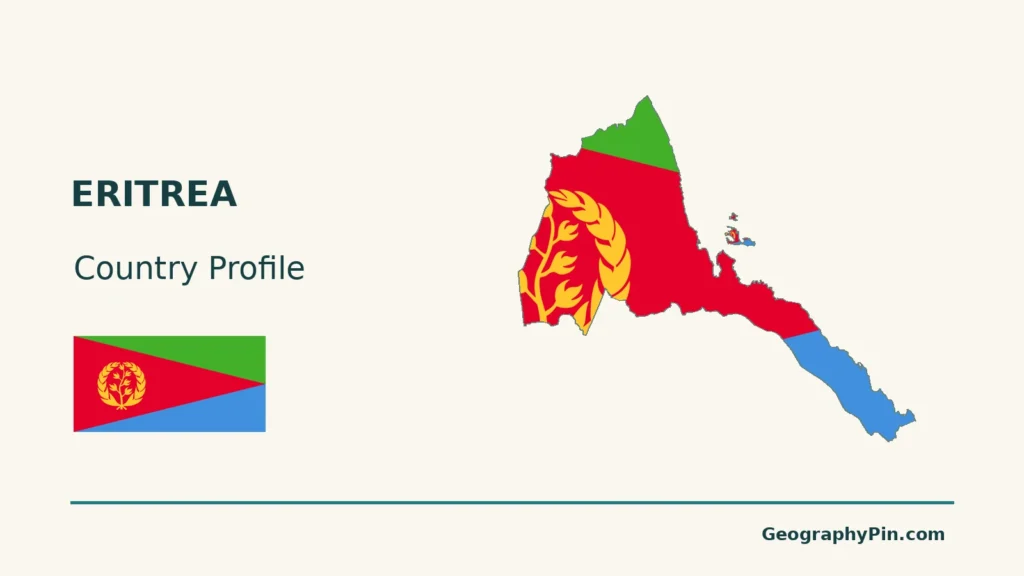
Map method: Original GeographyPin maps use public-domain Natural Earth countries 5.1.1. All three source components are retained: mainland Eritrea and two Dahlak islands. Smaller islands, including detailed Doumeira features, are not invented; no maritime allocation is drawn. Generalized source borders are not a surveyed implementation of the Ethiopia boundary award or a current-control map, and do not resolve the Djibouti dispute. November 2026 is the status-review date, not a geometry survey date. GeoNames coordinates are credited under CC BY 4.0. Landscape labels are reference locations, not bounded regions. Real Mapzen Terrain Tiles provide relief with Mapzen/USGS and upstream credits. Genuine below-sea-level terrain is retained; isolated negative spikes are transparent, not assigned invented heights. WGS84 scales apply at their displayed latitude. The cover uses the same source outline and Commons CC0 flag rendition, with a complete separate flag for editorial identification.
