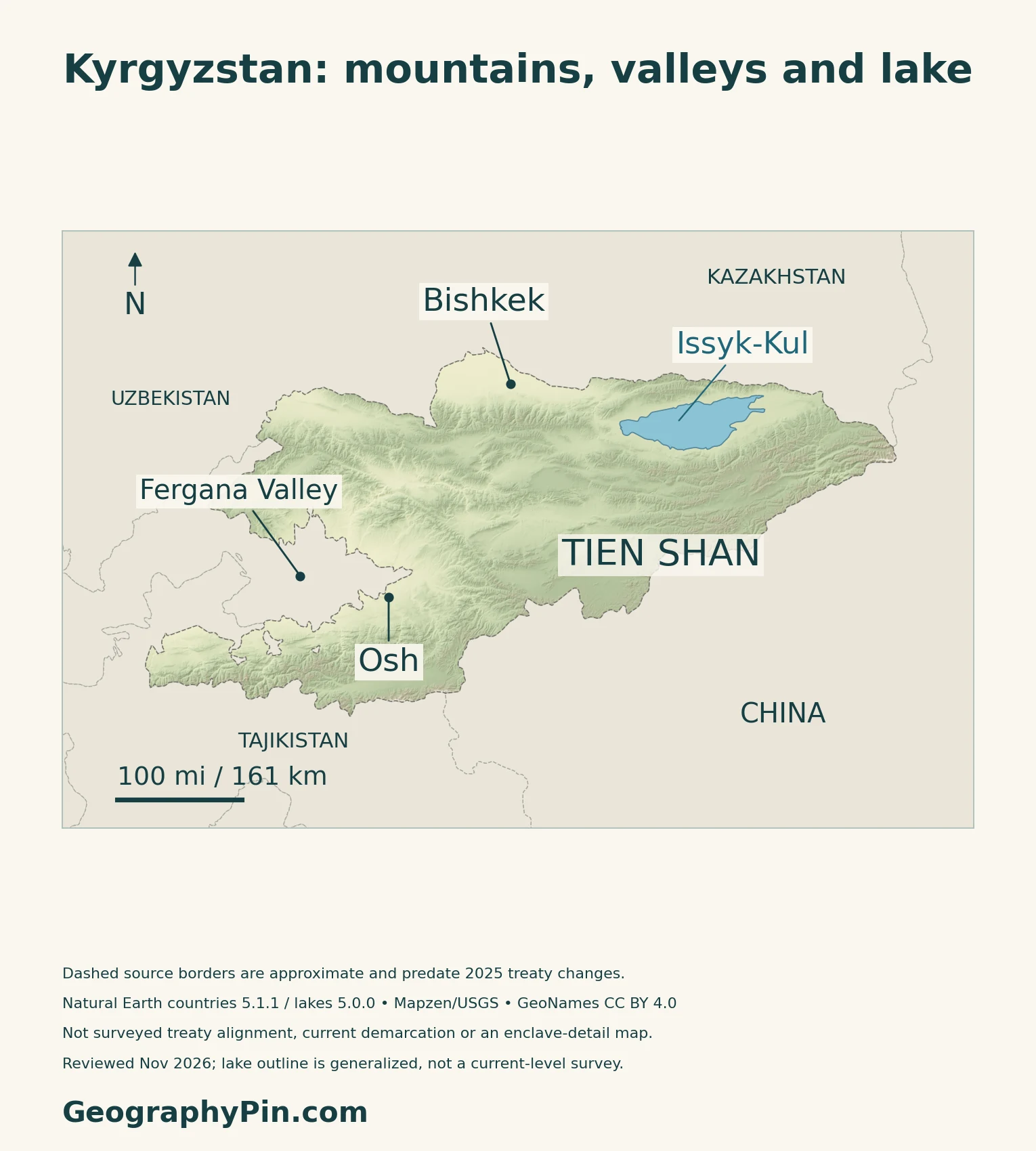
Kyrgyzstan’s mountain ranges divide the country into valleys, high basins and lake country rather than one continuous inhabited plain. Bishkek and Osh occupy very different settings, while Issyk-Kul forms a large basin within the Tien Shan.
Kyrgyzstan is a landlocked country in Central Asia, with Bishkek as its capital. The Tien Shan dominates much of its terrain, while the southwest connects with the Pamir-Alay mountain system and Fergana Valley. Elevation and mountain shelter create contrasting climates. Issyk-Kul occupies a closed basin, separate from river systems carrying mountain water toward neighboring countries.
How to use this article: Locate the country on the map, read the physical map, explore regional climates, or check the population reference.
1. Locate Kyrgyzstan and Its Main Cities
A landlocked country in Central Asia
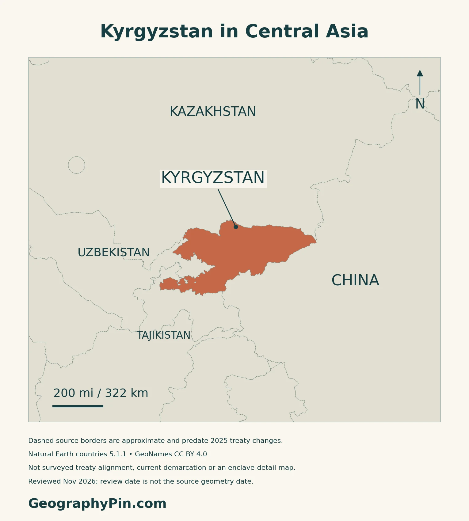
Kyrgyzstan, formally the Kyrgyz Republic, is a landlocked country in Central Asia. It borders Kazakhstan to the north, China to the east and southeast, Tajikistan to the southwest, and Uzbekistan to the west. Its southern valleys connect with the wider Fergana region across national borders.
Bishkek and the southern city of Osh
Bishkek is the national capital, near the country’s northern edge. Osh is a separate southern city, not a second capital. The Constitution gives both cities republican significance, distinct from the surrounding regions.
The Tajik border agreement and the map
Kyrgyzstan and Tajikistan signed their state-border treaty on March 13, 2025, and exchanged ratification instruments on March 31. Delimitation, the legal agreement on the boundary, is different from demarcation, marking it on the ground. A July 2026 Cabinet report described the installation of the first border pillars. The generalized map is not a survey of the new treaty alignment or its detailed road and enclave arrangements.
2. Read the Mountains, Valleys and Lake Basin
Four settings explain the country better than one average
| Setting | Physical character | Why it matters |
|---|---|---|
| Northern valleys | Chuy and Talas valleys beside mountain ranges | Lower ground contrasts with the high interior |
| Issyk-Kul basin | Large lake enclosed by Tien Shan ranges | A distinct internal drainage basin |
| Inner Tien Shan | High valleys, ridges and upland pastures | Cold conditions and terrain constrain land use |
| Southwestern valleys and ranges | Fergana margins and Pamir-Alay terrain | Osh connects with a broader cross-border valley region |
The Tien Shan is a system of ranges, not one ridge
The Tien Shan extends beyond Kyrgyzstan into neighboring countries. Within Kyrgyzstan, successive ridges separate valleys and elevated basins. The southwestern Pamir-Alay adds another major mountain setting; it is misleading to label every southern mountain as part of a single Tien Shan ridge.
Issyk-Kul does not drain into the Chu
Issyk-Kul is a slightly saline, closed-basin mountain lake. Rivers enter it, but it has no present surface outlet; evaporation is a major route of water loss. The Chu passes the lake’s western end rather than flowing through it.
A 2023 sediment study describes an important east–west contrast around the lake: the western shore is drier and more sparsely vegetated, while the eastern side receives more precipitation. The lake also stores heat and moderates conditions close to its shore.
3. Why Regional Climates Differ
Elevation and exposure modify a continental climate
The World Bank–ADB 2021 climate profile links Kyrgyzstan’s continental climate to its inland Eurasian position, distance from oceans and nearby deserts. Elevation and relief then produce large local differences: lower valleys can have hot summers while the high interior remains much colder.
Rainfall also varies sharply. Exposed mountain slopes and sheltered valleys do not receive the same moisture. The profile’s 1991–2020 climate reference shows warmer northern and western lowlands and much colder high Tien Shan terrain. These are long-term patterns, not current weather or a forecast for a particular pass.
Mountain shelter can support forests as well as dry grassland
Sary-Chelek illustrates the effect of local relief. UNESCO describes a western Tien Shan basin sheltered by surrounding ranges, with snowy winters, warm wet summers and nut–fruit forests containing walnut, apple and pear. Its forests are one setting within a wider mosaic of meadows, steppe, rocky slopes and water.
The transnational Western Tien-Shan World Heritage property also recognizes wild relatives of cultivated fruit trees and diverse forest communities. That property consists of selected protected components across Kazakhstan, Kyrgyzstan and Uzbekistan; it does not designate the whole mountain system.
4. Mountain Water, Pastures and Regional Connections
The country feeds several different drainage systems
The Naryn belongs to the Syr Darya system, while the Chu and Talas flow toward Kazakhstan. Other southeastern catchments drain toward China’s Tarim basin. Issyk-Kul’s internal basin is separate from these outward-flowing systems.
Snow and glacier melt contribute to mountain river flow, but water availability depends on timing as well as total supply. The World Bank’s 2025 climate-and-development assessment links changing snow, ice and precipitation with shifts in river seasonality. More meltwater in one period does not mean a permanent increase in stored mountain ice.
Seasonal pastures and irrigated valleys serve different roles
The same assessment describes crop production concentrated in irrigable valleys such as Chuy, Talas and Fergana, while pastures occupy a much wider range of elevations. Herders may move livestock between higher summer pastures, or jailoo, and lower winter pastures.
Hydropower connects upland water with downstream users
The Naryn already supports a hydropower cascade that includes Toktogul Reservoir. The World Bank describes Kambarata-1 as a further development upstream, pursued by Kyrgyzstan with Kazakhstan and Uzbekistan. Its anticipated generation is not existing electricity output.
5. Dated Country Facts and Institutions
| Item | Reference | Date or scope |
|---|---|---|
| Capital | Bishkek | Constitution, Article 14 |
| Population | 7,499,400 residents | Preliminary estimate at October 1, 2026 |
| Surface area | About 77,201 sq mi (199,949 km²) | UN reference, 2023; not land-only |
| Language status | Kyrgyz: state language; Russian: official language | Constitution, Article 13 |
| Currency | Som (KGS) | 100 tyiyn |
| Government | Unitary republic | Constitutional structure |
| Administration | Seven regions and two cities of republican significance | Bishkek and Osh are listed separately from regions |
A resident estimate, not a new census
The National Statistical Committee’s October 2026 figure is preliminary and explicitly incorporates the 2022 Population and Housing Census. It measures the resident population, not all Kyrgyz citizens worldwide. The population reference and the UN’s 2023 surface-area reference describe different dates; the area is not a newly surveyed post-treaty total.
Languages and regional administration
The distinction between Kyrgyz as the state language and Russian as the official language is written into Article 13. The same article protects conditions for ethnic communities to preserve, study and develop their native languages.
The statistical regions are Batken, Jalal-Abad, Issyk-Kul, Naryn, Osh, Talas and Chui. Osh Region and Osh City are separate units, just as Bishkek is reported separately from Chui Region.
What Did We Learn Today?
Kyrgyzstan’s geography is organized around mountain ranges and the valleys and basins between them. Bishkek, Osh and Issyk-Kul occupy different settings. Relief helps explain climate contrasts, seasonal pastures and the routes taken by water. Issyk-Kul remains a distinct closed basin, while other rivers link Kyrgyzstan with its neighbors.
Sources & Data Notes
Population references retain their date, resident coverage and estimate or census status. Physical and climatic summaries are not current weather forecasts. FAO’s historical survey is used only for broad landforms and drainage relationships, not its old population, glacier or water-use statistics. The 2023 lake study supports its closed-basin setting. The 2021 climate profile and 2025 development report are separate dated assessments. Kambarata-1 project expectations are not operating generation. UNESCO’s Western Tien-Shan property covers selected components, not the entire range.
- National Statistical Committee: preliminary resident population, October 1, 2026
- National Statistical Committee: regional resident-population table, 2026
- UNData: Kyrgyzstan surface area, 2023
- Constitutional Court: Constitution, Articles 1, 13 and 14
- National Bank: national-currency law, Article 19
- Kabar / presidential press service: border-treaty ratification instruments, March 31, 2025
- Kabar / Cabinet: border demarcation, July 14, 2026
- FAO: Irrigation in Central Asia, AQUASTAT Survey 2012, Kyrgyzstan chapter
- Lenz and colleagues (2023): Modern sedimentation patterns in Lake Issyk Kul
- World Bank–ADB: Climate Risk Country Profile, Kyrgyz Republic (2021)
- UNESCO: Sary-Chelek Biosphere Reserve
- UNESCO: Western Tien-Shan World Heritage property
- World Bank: Kyrgyz Republic Country Climate and Development Report (2025), water and land resources
- World Bank: Kambarata-1 Hydropower Plant project and existing Naryn cascade
Map method: Original GeographyPin maps use public-domain Natural Earth countries 5.1.1 and lakes 5.0.0. Generalized source borders and interior rings predate the 2025 treaty changes; dashed lines indicate approximation, not unresolved status everywhere. They are not surveyed treaty alignment, current demarcation or a current enclave inventory. The supplied Issyk-Kul polygon is not a current water-level survey; no river connection through the lake is drawn. GeoNames coordinates are credited under CC BY 4.0; Fergana Valley and Tien Shan labels are regional references, not boundaries. Real Mapzen Terrain Tiles supply relief with Mapzen/USGS and upstream credits; invalid negative raster artifacts are transparent rather than replaced with invented heights. WGS84 scales apply at their displayed latitude. The cover uses the public-domain official-symbol Commons modern Kyrgyzstan flag rendition, with a separate complete flag for editorial identification and a generalized geographic silhouette.