Cambodia’s geography centers on lowlands where the boundary between land and water changes with the seasons. The Mekong and Tonle Sap organize much of this interior, but mountains, eastern uplands and a Gulf of Thailand coast give the country several distinct physical settings.
Cambodia is a Southeast Asian country bordering Thailand, Laos and Vietnam, with a coast on the Gulf of Thailand. Phnom Penh is its capital. Central lowlands contrast with surrounding uplands, while high Mekong water levels drive seasonal flow into Tonle Sap Lake through its connecting river; later, the lake drains back toward the Mekong.
How to use this article: Compare landscape settings, follow Tonle Sap’s seasonal flow, explore seasonal climate, or check population scope.
1. Locate Cambodia and Read Its Boundaries
Between the Mekong basin and the Gulf of Thailand
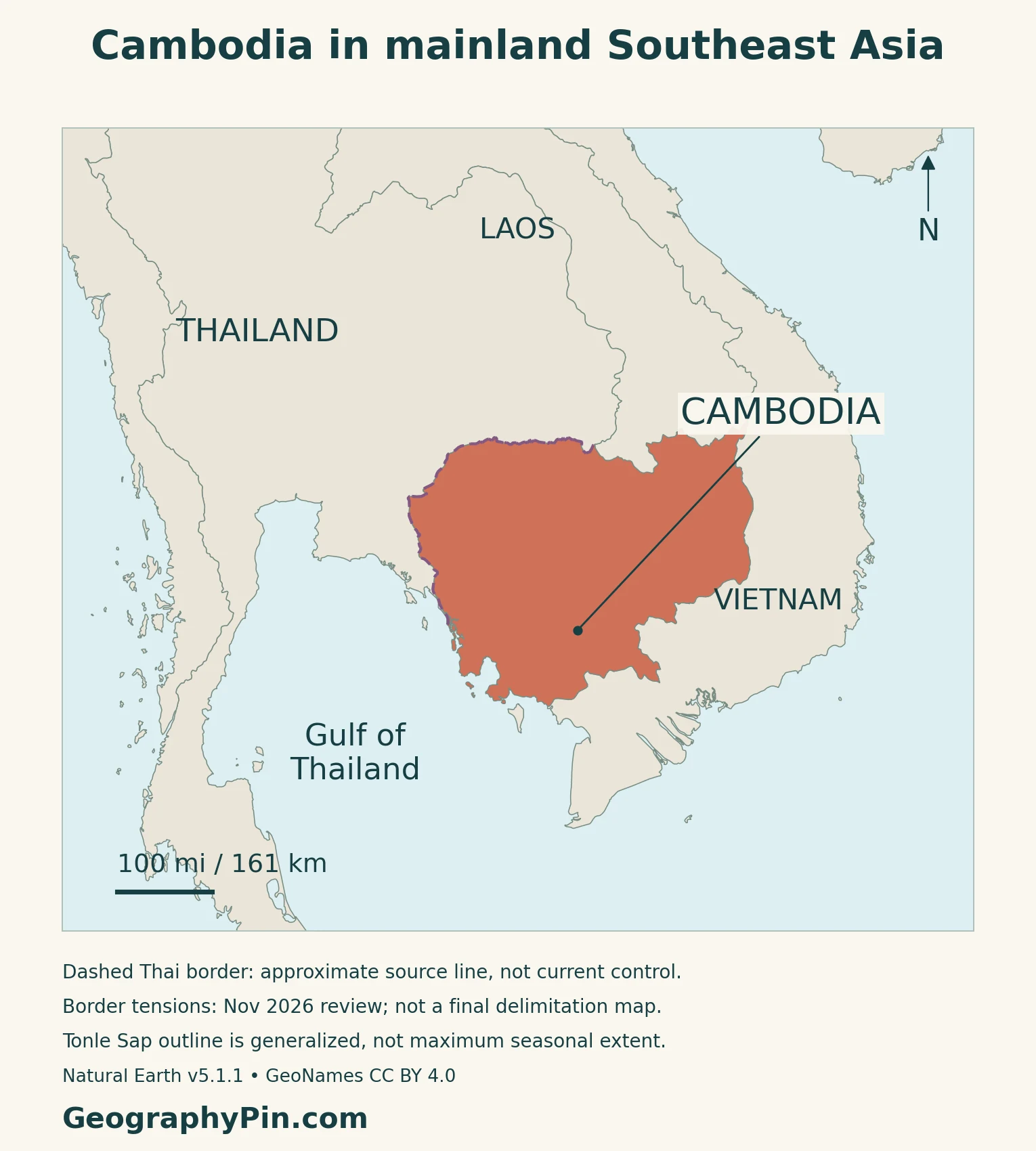
Thailand lies to Cambodia’s west and northwest, Laos to the north, and Vietnam to the east and southeast. The southwestern coast faces the Gulf of Thailand. Cambodia is therefore neither landlocked nor a country whose entire drainage system runs toward the same coast.
The locator map separates the national outline from its neighbors. The physical map then shows the contrast between the central basin and the higher ground around it. Neither map is a route-planning or border-crossing guide.
A generalized border is not a military-control map
Parts of the Cambodia–Thailand boundary remain disputed. Official accounts from both countries in October–November 2026 describe continued monitoring or bilateral tensions rather than a completed territorial settlement.
The Thailand-facing alignment is qualified on the maps. Dashed styling does not mean every segment is disputed, and it does not identify present troop positions or establish ownership of particular border sites. The line follows the source geometry rather than a newly inferred political boundary.
2. Central Lowlands and Surrounding Uplands
The country has more than one kind of lowland
The central alluvial plains surround Tonle Sap and extend toward the lower Mekong. To the north they meet the Dangrek escarpment; east of the Mekong they give way to higher terrain. In the southwest, the Cardamom and Elephant mountain systems separate much of the interior from the coastal strip.
| Setting | Physical character | Geographic connection |
|---|---|---|
| Central plains | Low-lying terrain around lake and river systems | Seasonal inundation, farming and major settlement corridors |
| Northern and eastern margins | Escarpment, hills and plateaus | Transitions toward neighboring upland landscapes |
| Southwestern mountains | Cardamom and Elephant ranges | A divide between interior and coastal catchments |
| Gulf coast | Narrow lowlands, bays and islands | Maritime access distinct from the inland river system |
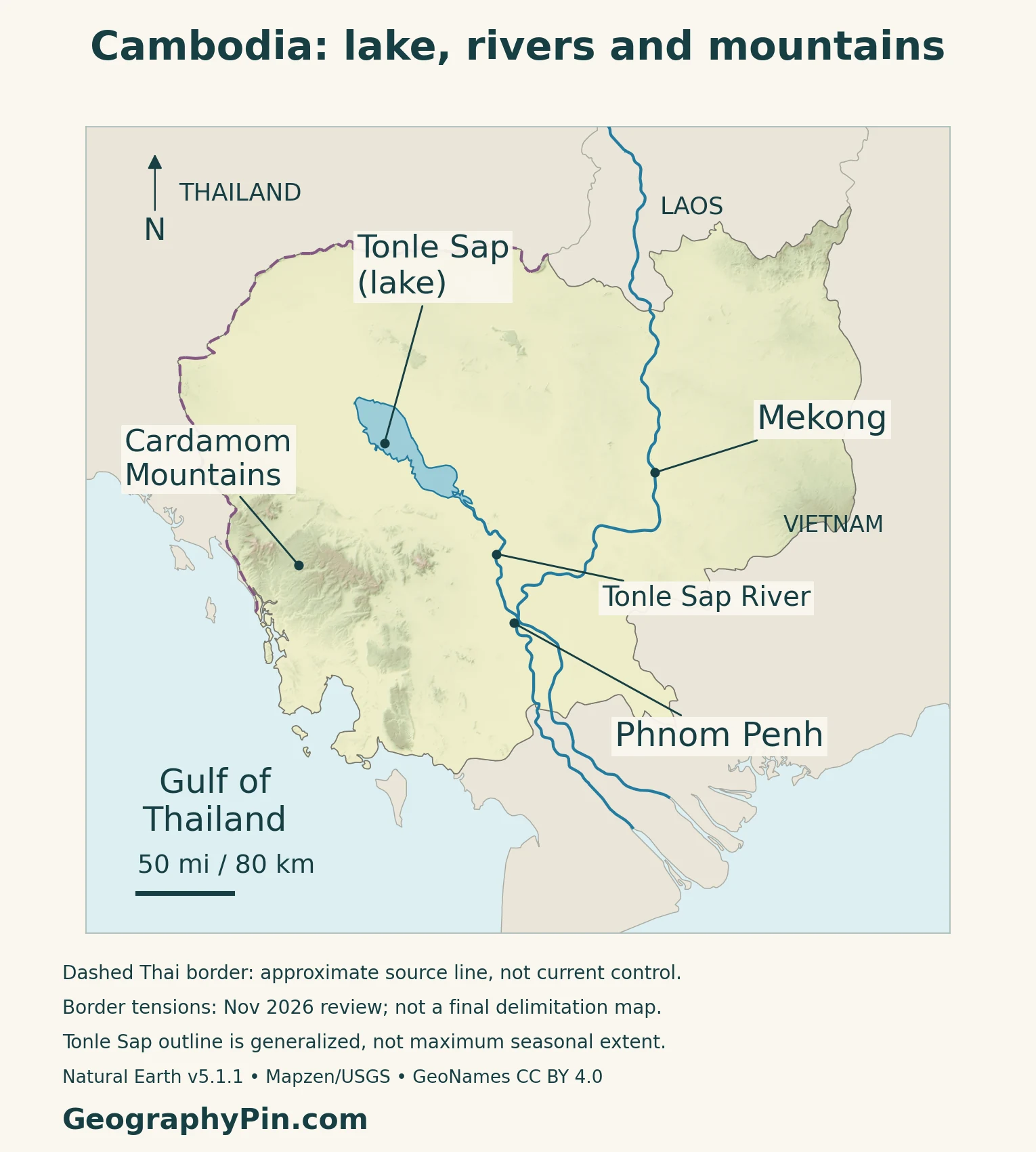
Mountains separate coastal rivers from the interior
Cambodian hydrologists describe the southwestern mountains as a watershed divide. Some streams descend toward the Gulf of Thailand; others flow toward the central Mekong–lake basin. A watershed is the land area draining toward a particular river or outlet.
This distinction prevents a common map-reading mistake: the presence of the Mekong does not mean every Cambodian stream is its tributary. The physical map’s landform markers identify reference locations, not precise boundaries of drainage basins or mountain ranges.
Phnom Penh occupies a river junction
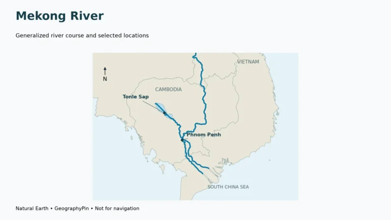
Phnom Penh stands at the junction of the Mekong and the Tonle Sap River, near the point where the Bassac branches from the main river system. That position connects the capital with the lake basin and the downstream delta.
The rivers continue toward Vietnam; the national boundary does not end the drainage network.
3. Tonle Sap, Monsoon Seasons and Flooded Forests
Why the Tonle Sap River changes direction
As high wet-season Mekong levels raise water at the junction, flow is pushed toward the lake; when the Mekong falls sufficiently, the lake drains outward again.
| Phase | Flow through the connecting river | Lake response |
|---|---|---|
| Rising Mekong flood | Toward Tonle Sap Lake | Water spreads into surrounding low-lying areas |
| Falling Mekong levels | From the lake toward the Mekong | Stored water drains and the flooded area contracts |
This is a seasonal pattern, not a fixed daily calendar. A single lake outline cannot represent every year or both high- and low-water conditions.
Rainfall varies across the country and through the year
The World Bank’s 2024 climate profile uses a 1991–2020 historical baseline. It describes Cambodia’s rainy monsoon broadly from May to October, with the national rainfall peak in September. Drier conditions generally occupy the remaining months, though the start and length of the seasons differ among provinces.
Higher terrain has cooler conditions than the plains. The report’s provincial comparisons also show substantial rainfall differences, so Phnom Penh’s climate is not a substitute for the coast, uplands or every part of the lake basin. Historical normals are not a forecast for a particular season.
Seasonal inundation creates habitat, not just open water
WCS Cambodia describes flooded forests and shrublands around Tonle Sap as feeding and rearing habitat for fish. The seasonal pulse also moves nutrients through the lake–floodplain system, while wetland habitats support important waterbird colonies.
The ecological connection extends beyond the lake’s permanent-looking blue shape on a small map. Floodplain vegetation and seasonally covered ground are part of the functioning landscape, even when they are not under water throughout the year.
4. Farms, Heritage and Coastal Connections
Seasonal water shapes farming decisions
The northern Tonle Sap basin supports rice, mango, cashew and vegetable farming. FAO’s March 2026 account of its work there describes farmers adjusting planting and fertilizer decisions to uncertain rain, heat and flood conditions.
The initiative combines agricultural and meteorological information through government cooperation, extension services and mobile advice. Its geographic lesson is practical: knowing that an area has a monsoon climate is less useful to a farmer than knowing when water will be available at the field.
Angkor is also a landscape of water engineering
Angkor, in Siem Reap province, includes reservoirs, canals, dykes and other hydraulic structures as well as temples and former urban layouts. UNESCO treats these features as part of the archaeological landscape, not merely as scenery surrounding individual monuments.
This adds a historical dimension to Cambodia’s relationship with water. The engineered features should not be confused with the natural seasonal behavior of Tonle Sap, even though both belong to the wider lowland setting.
The coast provides a different route to world trade
Sihanoukville Autonomous Port, on the Bay of Kompong Som, is Cambodia’s main deep-sea port. It provides a maritime gateway on the Gulf of Thailand, distinct from the inland river junction at Phnom Penh.
The contrast is useful when reading an economic map: river connections, coastal shipping and overland crossings serve different routes.
Physical geography does not explain the whole economy
The IMF’s September 2026 assessment identifies manufacturing exports and infrastructure investment as important supports to Cambodia’s economy in 2025. It also reports that border tensions with Thailand affected land-based tourism and remittances.
These connections show why the country cannot be described only through rice fields, fisheries or monuments. The landscape influences opportunities, but transport networks, cross-border relations and demand in external markets also shape livelihoods.
5. Country Facts with Dates and Scope
Cambodia: national reference facts
| Item | Reference |
|---|---|
| Capital | Phnom Penh |
| Population | About 17.28 million: 2024 inter-censal survey estimate |
| Surface area | About 69,898 square miles (181,035 square kilometers); UN reference year 2023 |
| Official language | Khmer |
| Currency | Riel (KHR) |
| Government | Constitutional monarchy |
| First-level administration | 24 provinces plus Phnom Penh capital municipality |
An inter-censal survey is not a full census
The National Institute of Statistics estimated 17,280,543 people in its Cambodia Inter-Censal Population Survey 2024. The survey used a weighted household sample, rather than visiting every household as a full census would.
Its population reference date was May 5, 2024, using a de facto approach based on where people spent the reference night. This differs from a usual-residence estimate.
Legal names and administrative areas need precise labels
The Constitution identifies Phnom Penh as the capital and Khmer as the official language and script. It establishes a constitutional monarchy, with a king who reigns rather than governs.
The first-level administrative structure comprises 24 provinces and the capital municipality, not 25 provinces. Phnom Penh’s administrative territory should not be confused with a separately defined metropolitan area or the continuous built-up city.
Surface area is not a fixed measure of dry ground
The UN surface-area figure includes more than dry land alone.
For regional context, use the Southeast Asia countries map and the Asia countries and capitals list.
What Did We Learn Today?
Cambodia’s central lowlands, surrounding uplands and Gulf coast form connected but distinct landscapes. Tonle Sap’s seasonal expansion matters to habitats and livelihoods, while the southwest watershed divide separates coastal drainage from the interior. Phnom Penh’s river junction and Sihanoukville’s maritime gateway illustrate different kinds of connection. National statistics and maps remain useful only when their dates, methods and limits are clear.
Sources & Data Notes
Population is a weighted 2024 inter-censal sample-survey estimate, not a full census count or a 2026 projection. NIS provenance was checked; the oversized official download exceeded retrieval limits, so the complete report was read through the linked Open Development Cambodia reproduction. Surface area is not land-only area. Historical physical accounts support enduring landscape relationships, not current forest cover or economic totals. Climate normals use 1991–2020. Border sources from both countries establish continuing sensitivity, not a new legal boundary or an endorsement of their contested allegations.
- WEPA: Cambodia physical geography, used for enduring landscape distinctions
- Cambodian hydrology officials: country statement in FAO flood-management proceedings
- Mekong River Commission: geographic regions and Tonle Sap seasonal flow
- WCS Cambodia: Tonle Sap habitats and floodplain ecology
- World Bank: Climate Risk Profile Cambodia (2024), via UNCCD
- FAO: climate information and northern Tonle Sap farming, March 2026
- UNESCO: Angkor’s archaeological and hydraulic landscape
- Sihanoukville Autonomous Port: operator overview, October 2026
- IMF: September 2026 assessment of Cambodia’s economy
- National Institute of Statistics: official inter-censal survey publication index
- NIS: Cambodia Inter-Censal Population Survey 2024, full report reproduced by Open Development Cambodia
- UNFPA Cambodia: final-report publication record, March 2025
- UN Statistics Division: surface area and currency; population projection not used
- Cambodian Ministry of Environment: Constitution, stable capital/language/monarchy provisions
- UK PCGN: Cambodia toponymic factfile, 2026 administration and boundary notes
- Thai Ministry of Foreign Affairs: November 11, 2026 briefing, boundary context only
- AKP: October 18, 2026 report on border ceasefire monitoring
Map method: Original GeographyPin cartography uses public-domain Natural Earth v5.1.1 country, river and lake geometry with actual Mapzen/USGS elevation data. GeoNames reference points are used under CC BY 4.0. All six country-geometry components are retained, but this is not an exhaustive island inventory. The actual source Thailand-facing line is dashed as a general qualification, not a claim that every segment is disputed or a map of current military control. Tonle Sap’s lake polygon and connecting river are distinct source features; no invented flow arrows or channel connectors are added. The lake outline is neither a permanent shore nor maximum seasonal inundation. Cardamom is a reference marker, not a range boundary. The decorative feature retains the complete Angkor Wat emblem and a separate intact flag.