Rwanda’s hills shape more than its appearance: they influence where water flows, how land is cultivated and how settlements connect. Western highlands separate drainage toward the Congo and Nile systems, while lower eastern landscapes have different climate and water conditions. Reading those contrasts helps explain the country beyond its familiar nickname.
Rwanda is a landlocked African country in the Great Lakes region, with Kigali as its capital. Its geography includes western highlands, northwestern Virunga volcanoes, central hills and lower eastern landscapes. The Nile–Congo divide separates major drainage systems, while steep slopes make soil conservation and careful water management important to farming and settlement.
How to use this article: Compare hills and valleys, follow the two drainage directions, and see why slope management matters to farms.
1. Locate Rwanda in the African Great Lakes region
Rwanda is a landlocked country south of the Equator in the African Great Lakes region. Uganda borders it to the north, Tanzania to the east, Burundi to the south and the Democratic Republic of the Congo to the west. Kigali, the capital, lies in the interior rather than beside Lake Kivu.
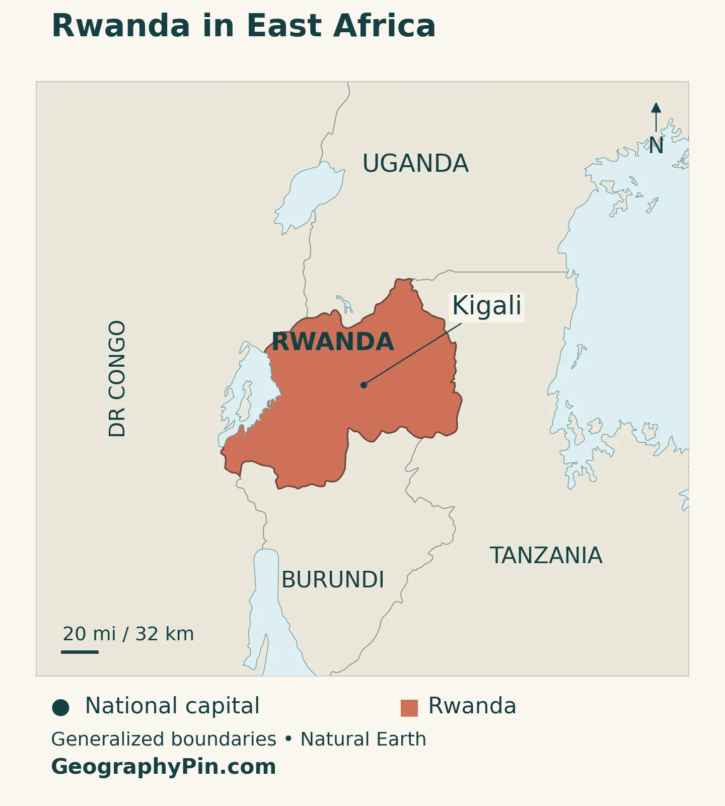
Lake Kivu forms part of the western boundary with the Democratic Republic of the Congo. It is a shared lake, not a body of water entirely inside Rwanda. On the other side of the country, the Akagera river system connects Rwanda with the much wider Nile basin.
Our East Africa countries map places Rwanda within the UN’s Eastern Africa grouping. “Great Lakes region” describes a broader geographical setting across several countries; it is not another name for Rwanda itself.
Start with the western highlands, the central hills around Kigali and the lower eastern landscapes. This west-to-east comparison explains more than the familiar “Land of a Thousand Hills” nickname, which conveys the character of the terrain rather than a literal hill count.
2. Country facts with a dated population benchmark
| Fact | Reference |
|---|---|
| Official name | Republic of Rwanda. |
| Capital | Kigali, designated by Article 7 of the Constitution. |
| Population projection | 14,418,145 at midyear 2026, NISR medium-scenario national projection. |
| Census population | 13,246,394 residents on August 15, 2022, fifth Population and Housing Census. |
| Surface area | About 10,169 square miles (26,338 square kilometers), UNData reference year 2023; includes inland water rather than land alone. |
| National language | Kinyarwanda, called Ikinyarwanda in the Constitution. |
| Official languages | Kinyarwanda, English and French under the Constitution; Kiswahili added by Organic Law 02/2017. |
| Currency | Rwandan franc (RWF). |
| Administrative structure | Four provinces and the City of Kigali, divided into 30 districts. |
The 2026 figure is a midyear projection, not a new enumeration. The 2022 census is the separately dated count of residents. NISR’s final main-indicators report distinguishes residents, urban and rural populations, and administrative units. Those definitions matter when comparing national totals with figures for Kigali.
Surface area is also not interchangeable with land area. Rwanda contains lakes and other inland waters, so a density calculated using land alone will differ from one based on the total national surface. A population-density comparison is meaningful only when both the population date and the area definition match.
3. Highlands, lake shores and lower eastern landscapes
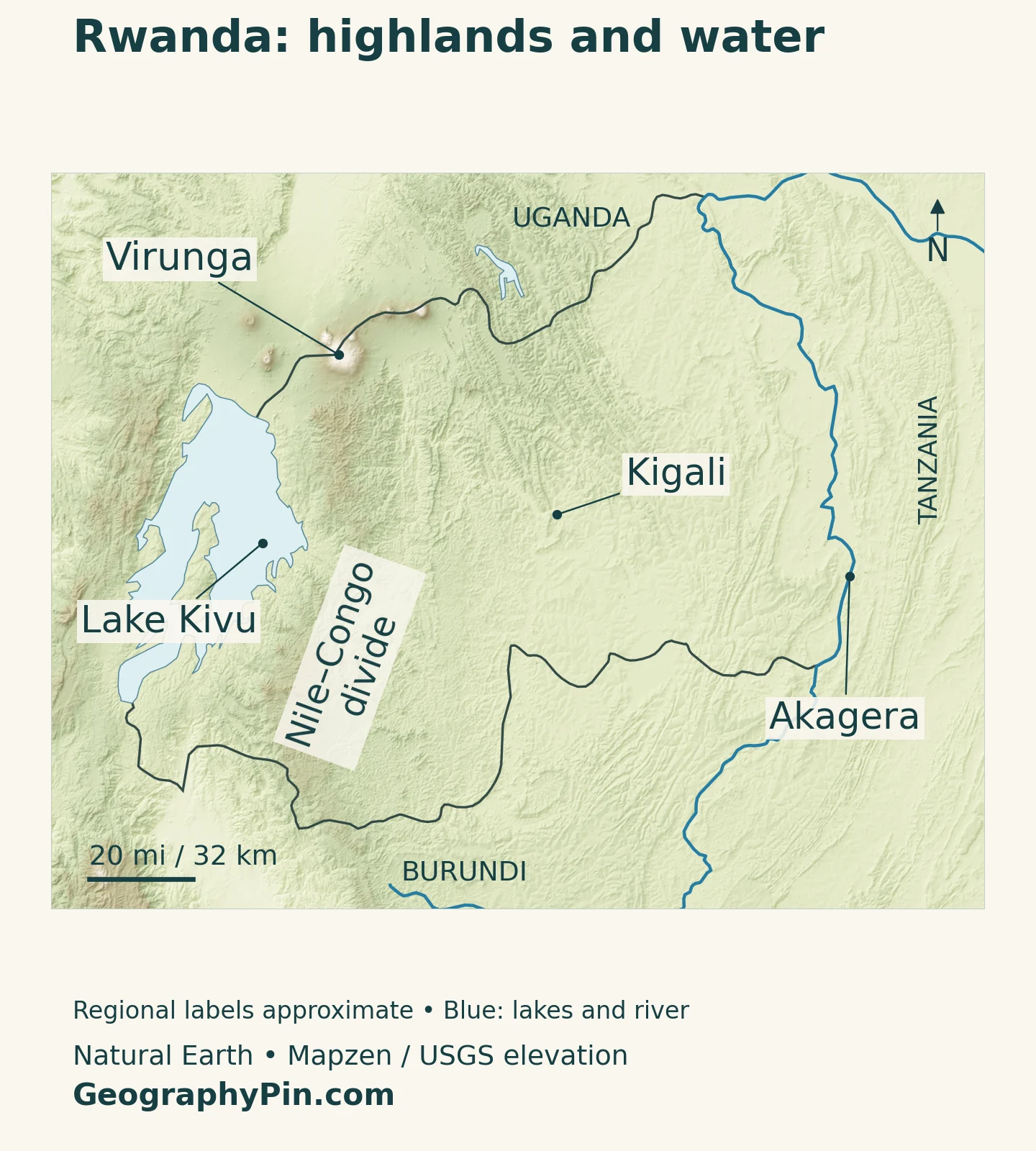
Rwanda’s relief rises toward the western highlands and the Virunga volcanic mountains in the northwest. The interior includes a central plateau broken by hills and valleys, while eastern landscapes are generally lower. The Bugarama valley in the southwest is another lower setting, so “west is high, east is low” is a useful first approximation rather than a rule without exceptions.
| Region | Main characteristics | Why it matters |
|---|---|---|
| Virunga and northwestern highlands | Volcanic mountains near the Uganda and DRC borders | High elevations contrast with the country’s lower valleys and plateaus. |
| Western highlands and Nile–Congo divide | Elevated terrain between major drainage systems | Rain falling on opposite slopes can enter different continental river basins. |
| Central plateau and hills | Undulating uplands, valleys and the Kigali area | Settlement and cultivation must work around slopes and drainage corridors. |
| Eastern lowlands and Akagera system | Lower terrain with river floodplains and lakes | Warmer, generally drier conditions coexist with important wetlands. |
| Lake Kivu shores and Bugarama valley | Lake-margin slopes and a lower southwestern valley | These settings differ from the high ridge farther inland. |
A hill landscape is not one uniform farming environment
A ridge, a cultivated slope and a wet valley bottom offer different conditions even when they are close together. Steepness affects runoff and erosion; elevation influences temperature; and valley drainage affects where water collects. Those differences help explain why nearby fields can require different management.
The physical map shows broad reference locations rather than exact regional perimeters. In particular, the Nile–Congo divide label identifies a western highland setting, not a surveyed watershed line. Administrative provinces and districts follow a separate system and should not be read as interchangeable with these landscape regions.
4. Two river basins divide the country’s drainage
The Nile–Congo divide separates destinations, not countries
A drainage divide is high ground separating water flowing into different river systems. Rwanda’s Nile–Congo divide runs broadly north–south through the western part of the country. It is not the national border, and neither the main Congo River nor the main Nile River runs along it.
On its western side, numerous short catchments drain toward Lake Kivu. The lake receives water from both Rwanda and the Democratic Republic of the Congo. Its outlet is the Rusizi River, which carries water south toward Lake Tanganyika within the Congo basin.
On the Nile side, the Nyabarongo and Akanyaru join to form the upper Akagera. The Rwanda Water Portal describes its broad, meandering floodplain and connections with nearby lakes. Water exchange between some lakes and the river can change with river flooding and local rainfall, rather than always moving in one fixed direction.
The lower Akagera follows part of the Rwanda–Tanzania border. Its connected wetlands and lakes belong to a river system, not isolated patches of water. Rainfall and land management upstream can therefore influence places well beyond the hillside where the water first fell.
Forests and cultivated slopes share the same water systems
Nyungwe in southwestern Rwanda protects montane forest as well as peat bogs, grasslands and other habitats. UNESCO’s World Heritage description emphasizes this variety rather than treating the protected area as one uniform forest type.
Outside protected forests, cultivated slopes are part of the same wider landscape. Soil washed from a field can enter streams and move downstream. The Rwanda Water Portal identifies sediment problems in western catchments such as the Sebeya, making erosion control relevant to rivers as well as agricultural land.
5. Elevation and rainfall shape the agricultural calendar
Near the Equator does not mean constant heat or rain
Rwanda Meteorology Agency describes a climate strongly modified by topography. Higher areas are cooler, while eastern lowlands and the Bugarama valley are warmer. The central and eastern parts are generally drier than the western highlands, partly because of their position relative to moisture-bearing air and elevated terrain.
There are two broad rainfall seasons: March–May and September–December. Their onset, duration and intensity vary by place and year. The seasonal movement of the Intertropical Convergence Zone, where tropical air flows meet, helps organize this pattern.
These are climate patterns, not a forecast for a particular week. Drought and flooding can both occur, and a wetter season does not ensure adequate rain at every stage of crop growth. Elevation, slope and the timing of rainfall need to be considered together when interpreting the agricultural landscape.
Why terraces are useful, but not a complete solution
Hilly terrain creates a practical farming challenge: runoff can remove soil from cultivated slopes, reducing the quality of the land and carrying sediment into streams. In March 2025, Rwanda’s Ministry of Agriculture explicitly linked the country’s hilly farming systems with vulnerability to soil erosion and called for stronger conservation agriculture.
Terraces modify a slope into shorter or more level cultivated sections. They can be combined with water-control structures, vegetation cover and other measures. Rwanda’s Land Husbandry, Water Harvesting and Hillside Irrigation project provides a documented example of an approach that combined terracing, irrigation infrastructure and post-harvest storage rather than relying on one intervention alone.
A peer-reviewed study modeling water erosion between 2000 and 2015 also identified the value of combining terracing with mulching and cover crops. Its results describe a model and historical scenarios, not a current measurement for every farm. The practical lesson is that protecting soil depends on management as well as the shape of the land.
Valley farming raises a different set of questions. Water may be easier to access, but wet ground and flooding require attention. The Bugarama valley’s irrigated rice cultivation illustrates a use of lower, wetter terrain that differs from rainfed farming on surrounding hillsides.
6. Kigali, rural settlement and national institutions
Kigali is the constitutional capital and a distinct top-level administrative area alongside the four provinces. It contains the districts of Gasabo, Kicukiro and Nyarugenge. A figure for the whole City of Kigali administrative area should not automatically be compared with a figure for a city’s continuously built-up footprint elsewhere.
The 2022 census classified 72.1% of Rwanda’s residents as rural. That dated finding explains why the country’s settlement geography cannot be reduced to its capital. Farming communities, local service centers and connections across hills and valleys remain essential parts of the national picture.
In a hilly setting, drainage and slope help determine which land is suitable for different uses. Roads and settlements must connect across changing elevations, while low areas may serve as drainage corridors rather than straightforward building land. These physical constraints do not determine settlement by themselves: infrastructure, planning and access to services matter too.
For a wider reference, our African countries and capitals list places Kigali alongside other national capitals.
Kinyarwanda is the national language. The Constitution names Kinyarwanda, English and French as official languages and permits organic legislation to add another; the 2017 organic law established Kiswahili as an official language.
The economy includes farming, services and industry, but the profile’s central geographical connection is the relationship between land, water and settlement. Hillside conservation protects productive soil; catchment management links upstream and downstream users; and local infrastructure connects rural communities with urban markets. Rwanda’s terrain is therefore a working landscape, not only a scenic description.
What Did We Learn Today?
Rwanda’s relief connects its climate, drainage and human geography. Western highlands divide the Congo and Nile basins, central hills support settlement and cultivation, and lower eastern areas contain important river and wetland systems. Terracing and other conservation measures address the practical challenge of keeping soil and water useful on cultivated slopes.
Sources & Data Notes
Population uses NISR’s medium-scenario midyear 2026 projection alongside its August 2022 resident census; rural share is a census result. The projection adjusts the census baseline to July 1 before modeling subsequent years. Surface area follows UNData’s 2023 reference. The water-portal sources support drainage geography and land-management examples; their older population tables are not used. Erosion research describes historical modeled conditions, not current measured loss on every farm. Regional labels are broad geographical references rather than administrative boundaries.
- NISR: 2023 population-projection report, Table 5.1, medium scenario at midyear 2026
- Rwanda Water Portal: Lower Akagera along the Tanzania border
- NISR: Fifth Population and Housing Census, main indicators, resident population and rural share
- UNData: surface area, region and currency
- Constitution of Rwanda, 2023: Articles 7–8, capital and languages
- Official Gazette: Organic Law 02/2017 establishing Kiswahili as an official language
- Government of Rwanda: provinces, Kigali and districts
- Government of Rwanda: national location and neighboring countries
- Rwanda Water Portal: Kivu catchment, western divide and sediment management
- Rwanda Water Portal: Upper Akagera and floodplain connections
- Rwanda Water Portal: Rusizi, Lake Tanganyika and Bugarama valley
- Rwanda Meteorology Agency: relief, temperature and rainfall seasons
- UNESCO: Nyungwe National Park and habitat diversity
- MINAGRI: March 2025 conservation-agriculture symposium and hillside erosion
- World Bank: Land Husbandry, Water Harvesting and Hillside Irrigation project evaluation, 2012–2016
- Nambajimana and colleagues: Land Use Change Impacts on Water Erosion in Rwanda
Map method: Original GeographyPin maps use public-domain Natural Earth country outlines, Kigali point, Lake Kivu polygon and Akagera river geometry. Shaded relief uses Mapzen Terrain Tiles with USGS SRTM/GMTED2010 data. Seven isolated invalid negative-elevation cells were replaced with neighboring valid-cell medians before rendering. Colors show elevation, not vegetation or rainfall. Virunga’s reference follows Smithsonian’s Karisimbi location; the label denotes the wider mountains. The Nile–Congo divide is a broad western-highland reference supported by Rwanda Water Resources Board, not an exact watershed line. Coastlines, lakes and borders are generalized; Web Mercator scale varies with latitude. The cover is an original flag-and-outline design.