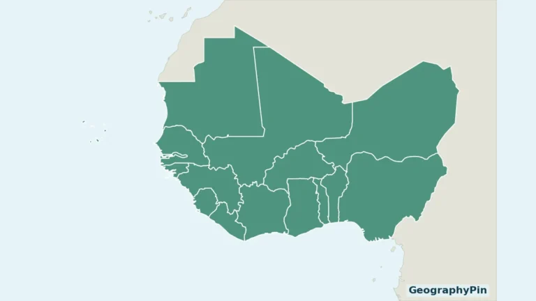
Nigeria’s geography brings coastal wetlands, major river valleys, central uplands and northern savannas into one country. Its two best-known cities also tell different stories: Abuja is the federal capital, while Lagos connects the southwestern coast with commerce and maritime trade.
From the Niger Delta to the northern savannas
Nigeria is a West African country bordered by Benin, Niger, Chad and Cameroon, with a southern coast on the Gulf of Guinea. Abuja is its capital. Its landscapes include coastal wetlands, the Niger–Benue valleys, the Jos Plateau, eastern highlands and northern savannas, linking contrasting climates with a large network of cities.
How to use this article: Locate the Jos Plateau, compare forest and savanna settings, or follow the Niger–Benue confluence toward the coastal delta.
1. Locate Nigeria between the coast and the Sahel
Nigeria is in West Africa. Benin borders it to the west, Niger to the north, Chad to the northeast and Cameroon to the east. Its southern coast faces the Gulf of Guinea, part of the Atlantic Ocean. Abuja, the capital and federal government seat, is inland; Lagos is on the southwestern coast.
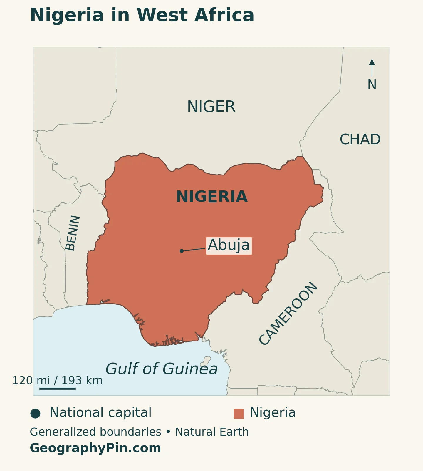
The country stretches across several environmental settings, so neither a Lagos skyline nor a photograph of the dry north represents it all. Start with the coastline, locate the Niger and Benue rivers, and then look for the plateaus and northern plains. Those features provide a stronger framework than a simple north–south split.
Our West Africa countries map supplies the wider regional setting. Keep the spelling straight: Nigeria and Niger are separate neighboring countries, while the Niger River crosses national borders before reaching Nigeria’s coast.
2. Country facts and population reference dates
| Fact | Reference |
|---|---|
| Official name | Federal Republic of Nigeria |
| Capital and government seat | Abuja, within the Federal Capital Territory (FCT). |
| Population reference | About 237.5 million: UNData’s 2025 projected estimate, medium-fertility variant. |
| Census comparison | 140,431,790 in the final 2006 Population and Housing Census results, as reported by Nigeria’s National Bureau of Statistics. |
| Surface area | About 356,669 square miles (923,768 square kilometers), UNData reference year 2023; not land area alone. |
| Official language | English; many Nigerian languages are also spoken. |
| Currency | Naira (NGN). |
| Federal units | 36 states and the Federal Capital Territory. |
The population reference is a dated projection, not a newly completed census. Nigeria’s National Bureau of Statistics explains that projections depend on assumptions about births, deaths and migration. Its demographic bulletin reports the final 2006 census count, which differs from the provisional total sometimes repeated on older pages.
The two figures in the table answer different questions: the census records a historical enumeration; the UN projection provides a later statistical estimate. Neither is a live population counter, and neither describes Lagos alone.
3. A landscape organized by valleys, plateaus and plains
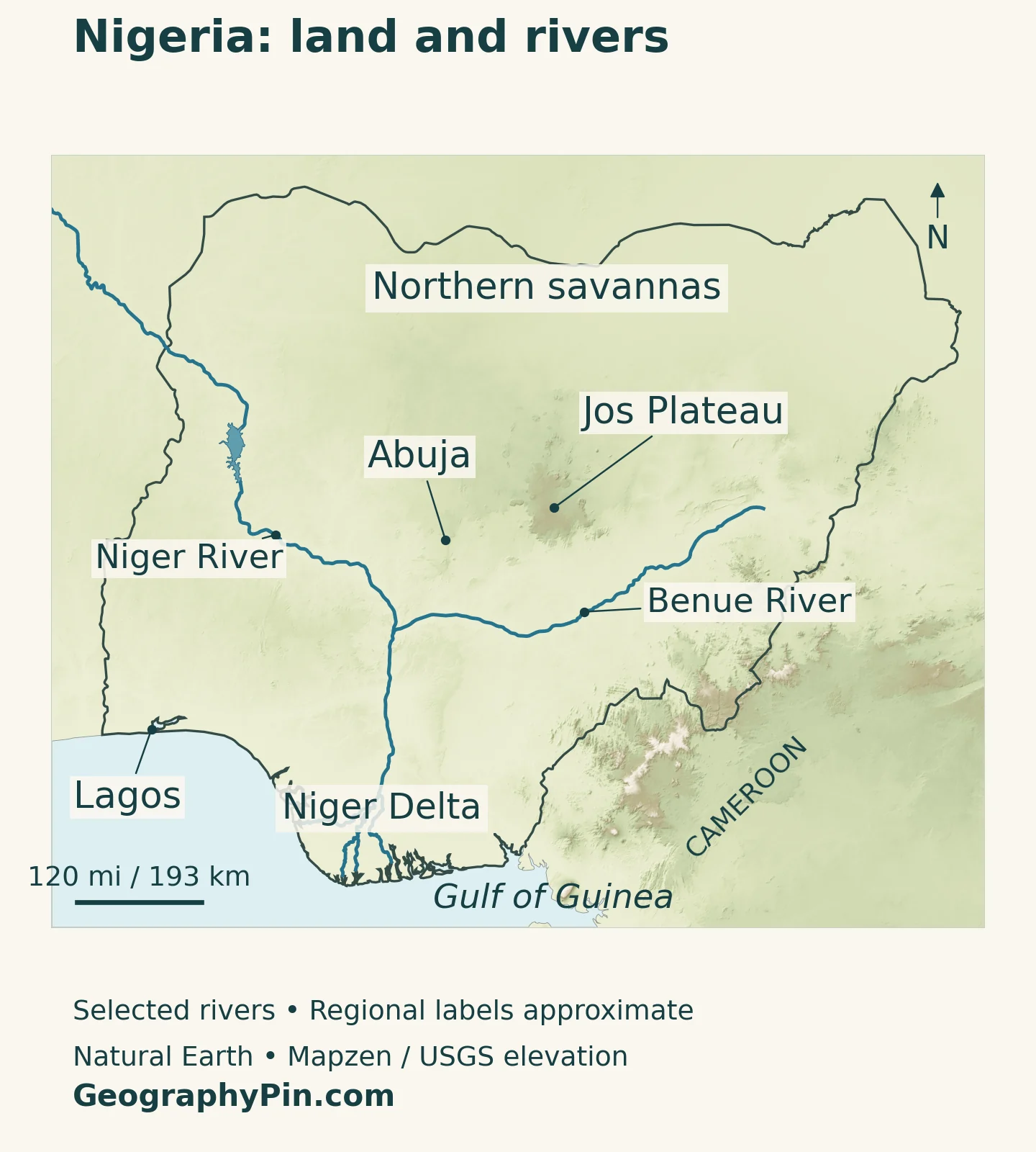
The Niger and Benue valleys form a major organizing pattern across Nigeria. Uplands rise on either side, while the lower Niger leads into a low coastal delta. Farther north, extensive savanna plains and the Lake Chad basin introduce different landscapes from those along the humid coast.
| Setting | Map reference | What to notice |
|---|---|---|
| Coastal plains and Niger Delta | Southern coast and lower Niger | Low terrain, wetlands, distributary channels and coastal settlements. |
| Niger–Benue valleys | Rivers meeting at Lokoja | A broad river framework connecting the interior with the coast. |
| Central uplands | Jos Plateau and surrounding interior | Higher ground interrupts any simple coast-to-north gradient. |
| Northern savannas and plains | Northern Nigeria | More strongly seasonal rainfall and extensive grassland and woodland settings. |
| Eastern highlands | Along the Cameroon frontier | A mountain and plateau borderland, not an extension of the coastal plain. |
The Jos Plateau adds a vertical dimension
The Jos Plateau rises above surrounding lower ground near the country’s center. Elevation helps distinguish its conditions from those of nearby lowlands: moving across Nigeria is not only a matter of moving farther from the sea. Other uplands, including the eastern border ranges, add further local contrasts.
Plateau State and the Jos Plateau are not interchangeable terms. One is an administrative unit; the other is a landform. The ACReSAL program’s account of Plateau State also highlights erosion linked to mining and land management, deforestation and siltation. Those concerns connect the uplands with water and soil management rather than treating the plateau solely as scenery.
Vegetation changes without forming neat administrative bands
Coastal mangroves and freshwater swamps differ from inland rainforest environments. Farther north, Guinea and Sudan savanna settings become important, with drier Sahel conditions toward the far north. These names describe broad ecological settings, not fixed lines that every farm or settlement follows.
Land use modifies that pattern. Farming, settlement, fire and woodland use can change what is actually visible within an ecological zone. A forest-region label should therefore not be read as a claim that all of the area remains intact forest, and a savanna label should not be mistaken for empty desert.
4. The Niger, Benue and the coastal delta
Two major rivers meet at Lokoja
The Niger and Benue meet at Lokoja. Below their confluence, the combined system continues south toward the Gulf of Guinea, where the Niger divides into distributaries. This branching coastal outlet is the Niger Delta.
The river system is larger than the part shown within Nigeria. Following the Niger upstream leads into other West African countries; following the Benue upstream leads toward Cameroon. Nigeria’s coastline is the downstream end of a cross-border drainage story, not the source of the whole system.
For the complete route and the distinction between the inland delta in Mali and the coastal delta in Nigeria, see our Niger River map. Here, the important country-level relationship is between the interior confluence and the coastal outlet.
The delta is a landscape, not one river mouth
A delta is not a single point where a blue line meets the sea. Channels divide across low ground, with wetlands and settlements between them. The physical Niger Delta should also not be confused with Delta State, one of Nigeria’s federal states. The shared name does not give them identical boundaries.
Oil production gives parts of the delta economic importance, but fishing, wetlands and communities are also part of its geography. UNEP’s environmental assessment of Ogoniland investigated oil contamination in land, water and ecosystems within that part of the Niger Delta. It is evidence from a defined study area, not a measurement of every location across the entire delta today.
Nigeria also has rivers outside the main Niger–Benue system. The Cross, Ogun and other coastal rivers drain toward the Atlantic, while the northeast includes drainage associated with Lake Chad. Not every stream on a Nigeria map ultimately joins the Niger.
5. Why rainfall seasons differ between south and north
Nigeria is tropical, but its wet and dry seasons vary considerably. The broad pattern is a longer rainy period in the south and a shorter rainy season, separated by a longer dry period, farther north. Elevation and local exposure complicate that pattern.
NOAA uses Lagos and Kano to illustrate the contrast. Its explanation links seasonal rainfall to the northward and southward movement of the tropical convergence zone and the changing influence of moist southwesterly and dry northeasterly winds. Lagos has a more extended wet-season pattern; Kano has a more concentrated rainy season.
The harmattan brings dry, dusty air from the Sahara during part of the dry season. It does not mean Nigeria as a whole has a desert climate. Nor does a generally dry northern setting rule out intense rainfall or flooding during the rainy season.
For agriculture, the relevant question is not simply whether a place is warm enough. The duration and reliability of rainfall, soils and access to water help determine the available growing season. A national seasonal description is useful orientation, but it is not a local planting forecast.
6. Abuja, Lagos and Nigeria’s wider urban network
Abuja and Lagos play different roles. The federal seat of power moved from Lagos to Abuja on December 12, 1991. Abuja is now the national capital and federal government seat. Lagos is a major commercial and port city on the southwestern coast. Political importance and commercial importance therefore do not point to the same place on the map.
The wider urban network is equally important. Kano provides a major northern commercial reference point; Ibadan lies in the southwest interior; Port Harcourt is associated with the southern coastal economy. These places show why Nigeria’s settlement geography cannot be reduced to a two-city comparison.
Ports connect coastal cities with international trade, but their significance extends inland through the movement of goods and people. The High Commission’s commercial-city and port listings identify centers across several parts of the country, not just the capital. A transport corridor connects places with different roles rather than making every city along it the same kind of center.
City population claims require particular care. Lagos State, an urban agglomeration and an individual administrative locality are not equivalent statistical areas. This profile avoids combining figures with different boundaries into an apparently precise city ranking.
English serves as Nigeria’s official language, while Hausa, Yoruba, Igbo and many other languages contribute to its multilingual society. A short list of widely used languages is not a complete inventory, and language communities do not divide into three tidy blocks on the national map.
7. Federal government, resources and regional connections
Nigeria’s Constitution establishes a federation of states and a Federal Capital Territory. The distinction matters: the FCT is not simply a thirty-seventh state. State boundaries organize government, whereas river basins, plateaus and vegetation regions describe different aspects of the same land.
Oil and natural gas are important resources, particularly in the Niger Delta and offshore. They do not explain the whole economy. Agriculture, manufacturing, trade, financial services, technology and creative industries are also part of Nigeria’s economic landscape.
The World Bank identifies electricity, transport and logistics gaps as obstacles to market integration and productivity. This is a geographical issue as well as an economic one: producing goods in one region does not automatically make it easy to move, store or sell them elsewhere.
The country’s physical variety helps frame these connections. Coastal access supports maritime trade, river valleys connect inland landscapes, and different rainfall regimes shape agricultural possibilities. But terrain does not determine prosperity by itself. Infrastructure, public services, institutions and environmental management influence how those geographical opportunities are used.
Frequently Asked Questions
Is Lagos or Abuja Nigeria’s capital?
Abuja is the national capital and federal government seat. Lagos is a major commercial and port city, but it is not the present national capital.
Are Niger and Nigeria the same country?
No. Niger is Nigeria’s northern neighbor. The Niger River is a separate geographical feature that flows across borders and reaches the sea through Nigeria’s coastal delta.
Is northern Nigeria entirely desert?
No. Northern Nigeria includes extensive savanna landscapes, plains and upland areas. The far north is drier than the humid coast, but treating all of northern Nigeria as desert hides important environmental differences.
What Did We Learn Today?
Nigeria’s map becomes clearer when its coastal wetlands, river valleys, uplands and northern savannas are read together. The Niger and Benue meet at Lokoja before the lower river reaches its coastal delta; Abuja and Lagos illustrate the difference between a political capital and a major commercial center. Physical regions cross administrative boundaries, and population totals are meaningful only when their dates and definitions remain attached.
Sources & Data Notes
Population uses UNData’s 2025 medium-fertility projected estimate, with the final 2006 census total supplied separately from Nigeria’s National Bureau of Statistics. Surface area follows UNData’s 2023 reference, converted to rounded square miles. Older physical-geography sources support stable terrain and drainage descriptions, not present-day population, infrastructure totals or economic percentages. Environmental findings from Ogoniland are not generalized to every part of the Niger Delta.
- Federal Ministry of Industry, Trade and Investment project report, page 3: federal-seat relocation in 1991
- UNData: 2025 population projection, surface area and statistical footnotes
- National Bureau of Statistics: Demographic Statistics Bulletin 2022, final 2006 census count and projection definitions
- Senate Committee on Constitution Review: Constitution, Chapter 1, states and FCT
- Nigeria High Commission, Canberra: capital, languages and economic sectors
- Nigeria High Commission, London: physical geography and commercial centers
- FAO: Nigeria’s river drainage and wetland geography
- FAO: Nigeria’s broad relief and vegetation context
- ACReSAL: Plateau State environmental challenges
- NOAA: Lagos–Kano contrast and seasonal rainfall
- UNEP: environmental assessment of Ogoniland
- World Bank: market integration and infrastructure constraints
Map method: Original GeographyPin maps use public-domain Natural Earth boundaries, city locations, Niger and Benue river paths and Kainji Reservoir geometry. Shaded relief uses Mapzen Terrain Tiles with USGS SRTM and GMTED2010 data. Terrain colors show elevation, not vegetation. Maps use Web Mercator; scale varies with latitude. River and reservoir outlines are generalized, not current water-level measurements. Not every tributary or delta channel is shown. Jos Plateau, Niger Delta and northern-savanna labels locate broad regions, not surveyed boundaries. The cover is an original flag-and-outline design.