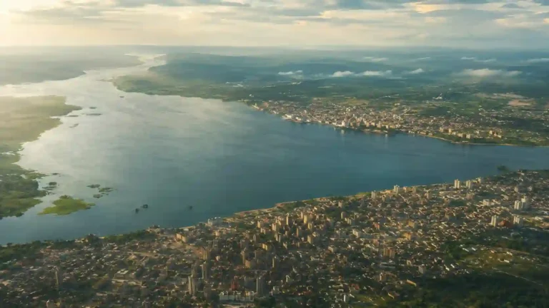
A river capital and an Atlantic port reveal two sides of the Republic of the Congo. Brazzaville faces Kinshasa across the Congo River, while Pointe-Noire opens onto the ocean. Between and beyond them lie wooded hills, savanna plateaus, river valleys and the forested lowlands of the western Congo basin.
The Republic of the Congo is a Central African country with Brazzaville as its capital and an Atlantic coastline around Pointe-Noire. Often called Congo-Brazzaville, it is separate from the Democratic Republic of the Congo. Its geography combines northern basin forests and wetlands with central plateaus, southwestern hills and a coastal plain.
How to use this article: Clarify the country names, compare the major landscapes, or see why river access and sea access differ.
1. Locate Congo-Brazzaville
The Republic of the Congo straddles the equator in Central Africa. It borders Gabon, Cameroon, the Central African Republic, the Democratic Republic of the Congo and Angola’s Cabinda exclave. Its southwestern coast faces the Atlantic Ocean.
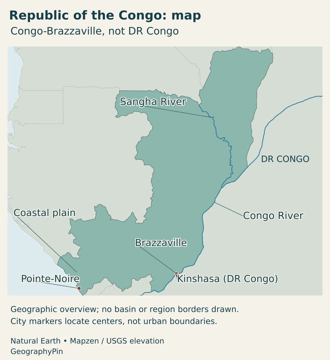
The country extends from the Atlantic side of Central Africa into the western part of the Congo basin. That position explains why some of its rivers join the Congo system while others reach the ocean through separate coastal catchments.
Congo-Brazzaville and Congo-Kinshasa are separate
“Congo-Brazzaville” distinguishes the Republic of the Congo from the much larger Democratic Republic of the Congo, often called Congo-Kinshasa. Brazzaville and Kinshasa face each other across the river, but they are capitals of separate sovereign countries, not two districts of one city.
The word Congo can also mean the river, its drainage basin or the wider forest region. Those meanings do not share a single boundary. The existing guide to why there are two Congos explains the historical naming distinction; this profile concentrates on Congo-Brazzaville itself.
2. Country facts and the capital
| Item | Detail |
|---|---|
| Capital | Brazzaville |
| Population | 6,142,180 residents in the 2023 RGPH-5 census results, consolidated in the August 2024 government release. |
| Published surface area | About 132,047 sq mi (342,000 km²), UN profile figure with a 2023 reference. |
| Official language | French |
| National vehicular languages | Lingala and Kituba |
| Currency | Central African CFA franc (XAF), issued by BEAC. |
| Administrative framework | 15 departments, following the 2024 reorganization. |
| Main Atlantic port | Pointe-Noire |
The population entry is a dated census result, not a claim that the same number describes the population in 2026. Surface area follows the UN reporting convention; it is not a new boundary survey or an independently calculated dry-land figure. Square miles are rounded.
Brazzaville is the national capital. Pointe-Noire’s description as an economic or commercial capital refers to its port and business role, not to a second constitutional seat of government. Keeping the two roles separate makes the country’s urban geography easier to understand.
Census results describe the resident population under the census definition. They should not be confused with a later demographic projection, the number of citizens abroad or a metropolitan estimate. The government’s consolidated 2023 results recorded roughly 70% of residents in urban areas, a classification that is distinct from the area covered by continuous urban buildings.
3. From the Atlantic coast to the Congo basin
Four landscapes that explain the national map
| Setting | Landscape | Why it matters |
|---|---|---|
| Atlantic coastal plain | Lower coastal terrain around Pointe-Noire, with beaches, lagoons and river mouths. | Connects the country directly to maritime trade. |
| Mayombe, Chaillu and Niari country | Wooded uplands and a lower valley corridor in the southwest. | Creates contrasts between forested hills, settlements and transport routes. |
| Central plateaus | Higher plateau country, including the Batéké landscapes, with extensive savanna settings. | Shows why the country is not uniformly low-lying rainforest. |
| Northern basin and Sangha setting | Forested country, tributary rivers and low-lying wetland environments. | Connects the Republic to the wider Congo basin and neighboring forest landscapes. |
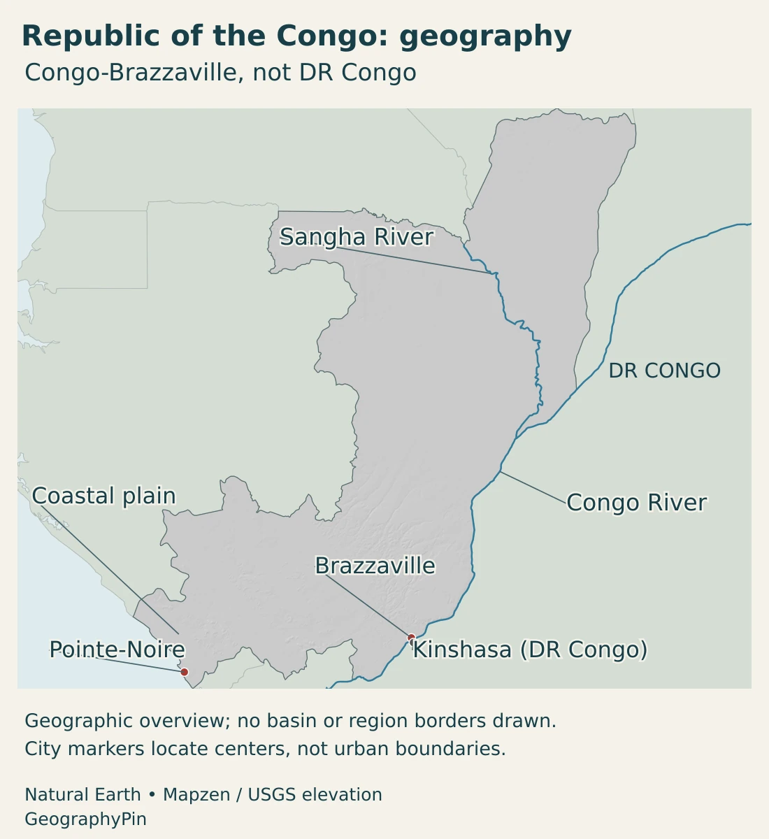
The coastal plain gives way inland to the Mayombe uplands. Farther inland, the Niari valley and the Chaillu massif add another set of contrasts. A journey between the coast and the interior therefore crosses changing terrain rather than following one broad flat plain.
The central plateaus include the Batéké landscapes. Savanna is an important part of the national environment, alongside forest. These more open landscapes are not simply gaps on a rainforest map; they are part of the country’s physical and ecological variety.
In the north and northeast, the lower Congo-basin setting includes extensive forests, wetlands and tributary valleys. Low relief can allow water to spread across broad areas during floods. Riverbank settlements, forest environments and seasonally inundated ground occupy different parts of this landscape.
The Sangha Trinational World Heritage property provides a concrete example of the northern forest setting. It spans adjoining protected areas in the Republic of the Congo, Cameroon and the Central African Republic. UNESCO describes humid tropical forest ecosystems alongside forest clearings, illustrating both environmental variety and connections across national borders.
4. Climate, forests and river systems
The Republic of the Congo has a warm tropical climate, but rainfall is not distributed evenly through the year or across the country. The northern equatorial setting generally has less sharply defined dry-season conditions than the more seasonal south. The transition is gradual, influenced by latitude and regional relief.
In the south, the main dry period falls broadly in the middle of the year, while wetter conditions occupy much of the remaining season. A national wet-season label should not be treated as a precise calendar for every northern forest location. Local observations and seasonal forecasts answer a different question from a broad climate description.
Forest and savanna occur in different combinations across the country. Forest is prominent in the north and in southwestern uplands such as the Mayombe and Chaillu. Savanna landscapes are important on plateaus and in parts of the southern interior. A national forest percentage alone would not show where these contrasts occur.
The Congo system and the separate coastal rivers
The Congo River forms an important part of the country’s eastern and southeastern setting. The Sangha and other tributaries connect northern landscapes with this larger international drainage system. Water reaching a national border does not stop there: upstream rainfall and downstream conditions belong to a shared basin.
The Kouilou–Niari system drains a different part of the southwest toward the Atlantic. It is not a tributary route through Brazzaville. This is a useful correction to the assumption that every river in a country called Congo must join the Congo River.
Brazzaville’s river access also differs from Pointe-Noire’s ocean access. Rapids downstream of the capital region interrupt a continuous navigable route to the sea. Roads and the Congo–Ocean railway connect the inland capital with the coastal port, linking different transport environments rather than merely duplicating an uninterrupted shipping channel.
In low-lying parts of the basin, flooding can disrupt settlement, cultivation and communications. A river is simultaneously a route, a source of water and a changing physical environment. The extent of floodwater at a particular time is different from the permanent river line shown on a reference map.
5. Cities, people and languages
Brazzaville and Pointe-Noire are the country’s two principal urban centers, but their locations reflect different functions. Brazzaville combines national administration with an inland river position. Pointe-Noire concentrates maritime connections and activities linked to the coast and hydrocarbons.
Between them, the southwestern transport corridor connects inland communities with the ocean. In the forested north, rivers and roads link more dispersed settlements. These patterns help explain why national averages can conceal large differences in population concentration and access to services.
The country has 15 departments following a reorganization in 2024, as documented in the United Nations country team’s 2025 annual report. Older references to 12 departments describe an earlier framework. Physical names such as Mayombe, Batéké and the Congo basin are not interchangeable with these administrative units.
Official and national languages
The Constitution makes French the official language and names Lingala and Kituba as national vehicular languages, meaning languages used for communication across communities. This differs from the neighboring DRC’s constitutional list, even though some languages are used on both sides of the border.
Language categories describe legal or public roles, not the full range of languages spoken in households and communities. They also do not imply that every resident uses the same languages in the same circumstances.
6. Government, ports and economic geography
The Republic of the Congo is a unitary republic. Its constitutional institutions include a president, a prime minister heading the government, and a parliament with a National Assembly and Senate. The president appoints the prime minister. These are descriptions of the institutional framework, not an assessment of political performance.
Pointe-Noire provides a clear connection between physical geography and economic activity. Its ocean-facing port serves maritime trade, while the route toward Brazzaville links it with inland markets. The railway and road corridor matter because the capital’s river location does not by itself provide an unobstructed seagoing connection.
Hydrocarbons are a major part of the economy, but the country is not only an oil-production landscape. Forest resources, wood processing, agriculture and logistics occupy different settings and depend on different kinds of infrastructure. A forest concession, a port terminal and an urban food market are connected through trade, but they are not interchangeable economic spaces.
A 2026 IFC diagnostic identifies processed wood, logistics along the Pointe-Noire–Brazzaville corridor, maize milling and aquaculture as potential avenues for diversification. These are opportunities examined in the report, not a claim that every proposed investment has already been completed.
Wood processing links forest resources with transport and markets. Agricultural processing depends on connections between producing areas and consumers. Aquaculture depends on suitable water resources and operating conditions. In each case, geography helps explain the opportunity, while infrastructure and institutions influence whether it can be realized.
The national picture is therefore a connection between several landscapes: an Atlantic gateway, an inland capital, southwestern valleys and uplands, central plateaus and northern forests. Understanding those connections is more informative than treating the Republic of the Congo as a smaller copy of its neighbor across the river.
Frequently Asked Questions
Is Congo-Brazzaville the same country as DR Congo?
No. The Republic of the Congo has Brazzaville as its capital; the Democratic Republic of the Congo has Kinshasa. They are separate countries on opposite sides of part of the Congo River.
Is Pointe-Noire the capital of the Republic of the Congo?
No. Brazzaville is the national capital. Pointe-Noire is the major Atlantic port and is often described as an economic or commercial capital because of its business role.
Does every river in the Republic of the Congo drain into the Congo River?
No. The Sangha connects to the Congo system, but the Kouilou–Niari drains southwestern country separately toward the Atlantic.
What Did We Learn Today?
Congo-Brazzaville combines an Atlantic coastline with the western Congo-basin setting. Brazzaville is the capital, while Pointe-Noire is the maritime gateway. Coastal plains, wooded uplands, savanna plateaus and northern forests create contrasting environments. The Congo and Kouilou–Niari belong to different drainage settings, and the country is distinct from the Democratic Republic of the Congo.
Sources & Data Notes
Country statistics refer to the Republic of the Congo, not the Democratic Republic of the Congo. Statistical dates and definitions are stated beside the figures. Reviewed in November 2026.
- Government, consolidated RGPH-5 results: August 2024 cabinet release: 2023 census resident population and urban classification.
- UNData, Congo country profile: Surface area with a 2023 reference and Central African CFA franc currency. This is the Republic of the Congo profile, not the DRC profile.
- Government Secretariat, Constitution: Articles 1 and 4: capital and languages; Articles 83, 98 and 107: government and parliamentary institutions.
- United Nations Congo, annual report 2025: Administrative organization into 15 departments since 2024.
- FAO, national forestry outlook background: Broad physical regions: coastal plain, Mayombe, Chaillu, Niari valley, central plateaus and northeastern basin. Historical background for landforms, not a current statistical inventory.
- Republic of the Congo, first national communication: September 2001 report: Congo and Kouilou–Niari drainage, Sangha tributary setting and lowland flood processes.
- ProClimat Congo, environmental and social framework: December 2022 national project document: regional climate and landscape contrasts.
- UNESCO, Sangha Trinational: The shared World Heritage property and its humid forest and clearing environments.
- USGS, lower Congo field investigation: Primary hydrologic observations of rapids downstream of the Brazzaville–Kinshasa region.
- US International Trade Administration, transport connections: The Pointe-Noire port and railway connection to Brazzaville.
- IFC, Republic of Congo private-sector diagnostic: 2026 diagnostic overview: economic diversification opportunities in wood processing, logistics, maize milling and aquaculture. Opportunities are distinguished from completed investments.
Map sources and scope: Original GeographyPin maps use public-domain Natural Earth country outlines, city coordinate attributes, lake polygons and river lines. The Republic of the Congo is retained as a separate country from the Democratic Republic of the Congo. Boundaries are generalized reference geography, not official claims or current-control mapping.
Brazzaville, Kinshasa and Pointe-Noire markers use source city coordinates, not urban boundaries. The two capital markers nearly meet at this country scale. The coastal plain label is a broad orientation point, not a measured region boundary. Actual Congo and Sangha source lines are shown, but the source omits the lower Congo estuary: the drawn line is not a complete source-to-mouth route. No drainage-basin perimeter is invented.
Relief is calculated from real elevations accessed through Mapzen Terrain Tiles. Global elevation data courtesy of the U.S. Geological Survey. Elevation-source attribution and terms apply. Shading shows terrain form, not numerical elevation bands or local navigation detail.
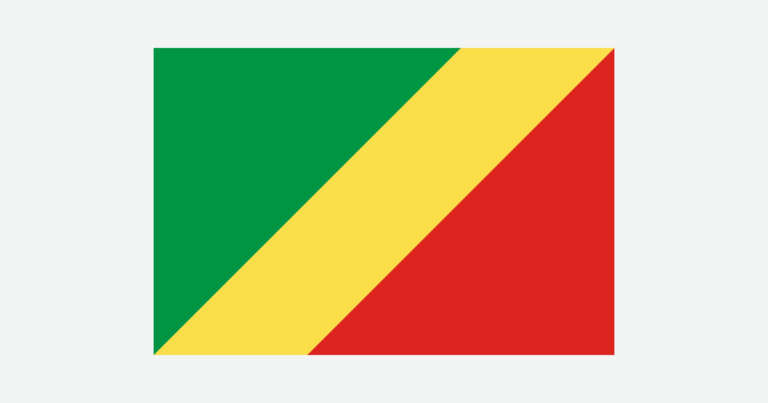
The cover uses Republic of the Congo flag artwork from Wikimedia Commons as a country-outline motif, with an intact flag, decorative divider and GeographyPin branding.