Peru is often pictured through an Andean mountain scene, but that leaves much of the country out. Its Pacific coast, high valleys and plateaus, eastern cloud forests and Amazonian lowlands form a connected sequence of very different landscapes. The mountains help explain not only the scenery, but also where rain falls, where rivers flow and how settlements connect.
Peru lies on South America’s western side, with a Pacific coast, the Andes running through its interior, and Amazonian slopes and lowlands to the east. Lima is the capital. The familiar coast–highlands–forest division is a useful introduction, but altitude, drainage and regional rainfall create important differences within each of those broad settings.
How to use this article: Compare the main landscapes, trace the three drainage systems, or distinguish Lima from Peru’s historical capital.
1. Locate Peru on South America’s Pacific side
The Republic of Peru faces the Pacific Ocean in western South America. Ecuador and Colombia lie along its northern side, Brazil to the east, Bolivia to the southeast and Chile to the south. Its territory extends far beyond the narrow coastal strip visible beside the ocean.
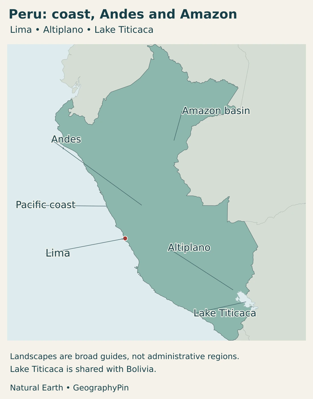
The Andes run broadly parallel to the Pacific margin, but the country is not a single mountain ridge. Western valleys lead toward the coast; eastern valleys connect with the Amazon system. In the southeast, the high Altiplano and Lake Titicaca form another distinctive setting shared with Bolivia.
Three Spanish terms often organize descriptions of Peru: costa for the coast, sierra for the highlands, and selva for the forest region. These are broad geographic divisions, not three provinces or three uniform climate zones. The eastern forest region includes mountain slopes as well as lowland plains.
2. Country facts, Lima and administrative scope
| Item | Reference |
|---|---|
| Capital | Lima; the constitution separately names Cusco the historical capital. |
| Population | 34,157,732 in the first 2025 census results, released in May 2026. This includes 32,706,028 people enumerated and 1,451,704 estimated omissions. |
| Reported total area | 496,225 sq mi (1,285,215.6 km²), INEI Compendio 2022 reference. Its total combines continental, lake and island categories; it is not a dry-land-only figure or a new 2026 survey. |
| Official languages | Spanish; Quechua, Aymara and other Indigenous languages are also official in areas where they predominate, according to law. |
| Currency | Sol (PEN). |
| Territorial organization | 24 departments and the Constitutional Province of Callao; regional-government arrangements require a separate distinction for Lima. |
The census-based population total includes an adjustment for people missed in enumeration. It should not be described as the number of completed individual census records or as a live 2026 count. Likewise, the published area belongs to its stated statistical reference, not to a fresh measurement of the generalized map below.
Lima and Cusco have different constitutional roles
Article 49 of the constitution names Lima as the capital of the republic and Cusco as its historical capital. The historical designation recognizes a different role; it does not make Cusco a second present-day national government capital.
Place names also need a clear statistical boundary. A city, its metropolitan area, a province and a department are different units. A total for a wider Lima urban region should not be substituted for a figure for Lima Province or Callao without saying which territory is included.
3. Coast, Andes and Amazon landscapes
A short cross-country comparison
The most useful starting point is a west-to-east cross-section: coastal land rises toward Andean ranges and valleys, then descends through eastern slopes into the Amazonian lowlands. The southeast also contains the broad high-elevation Altiplano. This sequence explains more than treating every famous Peruvian place as part of the same mountain landscape.
| Setting | Landscape | Geographic connection |
|---|---|---|
| Pacific coast | Coastal plains and valleys between the ocean and western Andean foothills. | River valleys, cities and ports connect the dry coast with inland water sources and transport routes. |
| Andean ranges and valleys | High ridges, deeply cut valleys, upland basins and glaciated peaks in some ranges. | Altitude and exposure create sharp local contrasts in climate, farming and access. |
| Altiplano and Titicaca | A high plateau and lake setting shared with Bolivia in the southeast. | This is a distinct drainage setting rather than simply a river flowing to the Pacific. |
| Eastern slopes and Amazonian lowlands | Cloud forests on slopes grading toward lower rainforest landscapes. | Rivers link mountain catchments with the wider Amazon basin. |
Coastal Peru is not uniformly a beach landscape. Much of the central and southern coast is dry, with cultivated and urban areas concentrated in valleys and supplied by water from inland catchments. Northern coastal conditions differ, particularly when unusually warm coastal waters accompany heavy rainfall.
The Andes contain both steep terrain and settled valleys. In the Cordillera Blanca, Huascarán National Park protects high peaks, ravines and glacial lakes. That mountain setting is real, but it should not become a stand-in for every part of the country, or even for every Andean valley.
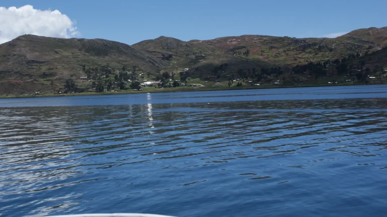
Farther southeast, Lake Titicaca lies on the Peru–Bolivia border in the Altiplano. Its water and surrounding plateau form a shared geographic system; the lake is not wholly Peruvian. The dedicated lake guide explains its dimensions, elevation and navigation terminology in more detail.
Manú National Park makes the eastern transition especially clear. Its landscapes extend from high Andean grasslands through cloud forests to lowland rainforest. The change is not an abrupt switch from bare mountains to one flat jungle: altitude, moisture, soils and river valleys produce a sequence of habitats.
4. Climate and the three drainage systems
Why a tropical-latitude coast can be dry and foggy
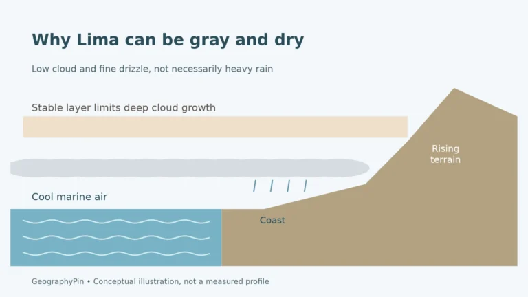
Latitude alone does not explain Peru’s climate. Cool coastal water, atmospheric circulation and the Andes all influence conditions. Along parts of the Pacific coast, low marine clouds and fog can coexist with very little rainfall. Humid air near the surface is not the same as a rainy climate.
Off Peru, upwelling brings cool water toward the surface. The air above it cools, helping low clouds form, while stable atmospheric conditions limit their vertical growth. Clouds can move into valleys open to the sea. In suitable places, fog supplies moisture to vegetation communities known as lomas.
The northern coast is generally warmer and can receive much heavier rain than the central and southern coastal desert, especially during damaging El Niño-related events. This does not mean every El Niño produces the same rainfall everywhere. A description of the normal coastal climate is not a forecast for a particular season.
Altitude and the eastern slopes change the pattern
In the highlands, temperature changes strongly with elevation, while rainfall varies with location and exposure. A valley floor, a high plateau and a mountain summit should not share one climate label merely because all are Andean. The eastern slopes and Amazonian lowlands generally have much wetter conditions than the Pacific desert.
Forest geography also changes with height. Manú’s transition from upland grasslands through cloud forest to lowland rainforest shows why the Amazonian side cannot be reduced to one vegetation band. Rivers and slopes connect these environments, even where their climates and plant communities differ.
Three drainage systems, not every river flowing to one ocean
Peru’s official hydrographic mapping groups drainage into the Pacific, Amazon and Titicaca systems. The distinction concerns where water drains, not administrative boundaries. West-flowing rivers reach the Pacific; much of the eastern drainage joins the Amazon network; the Titicaca system occupies a separate high-basin setting.
The Amazon basin includes land drained by the river and its tributaries. It is not identical to a rainforest boundary: mountain headwaters can belong to the basin even where the landscape is not lowland tropical forest. The basin also extends beyond Peru into other countries.
Within Manú, streams from the mountains feed the Manú River, which joins the Madre de Dios. This provides a concrete example of an Andean-to-lowland connection rather than two isolated landscapes. A national river map is necessarily selective and does not show every tributary or the changing width of floodplains.
5. People, cities and languages
The 2025 census results identify the coast as Peru’s main population concentration and Lima as its largest provincial population center. This is an important correction to the image of Peru as a predominantly high-mountain society. Coastal cities, Andean urban centers and Amazonian communities all belong to the same national picture.
The INEI release treats Lima Metropolitana and the Constitutional Province of Callao separately in its provincial comparisons. Larger metropolitan statistics may combine them, so a number labeled simply “Lima” needs its boundary explained before it is compared with another city.
The coast, highlands and eastern lowlands all contain lived-in landscapes. Their settlements have different relationships with roads, rivers, agriculture and regional markets. A sparsely populated forest region is not empty land, and a national map cannot represent the full geography of Indigenous communities with a few city dots.
Official status follows both national law and regional presence
Article 48 makes Spanish official and also recognizes Quechua, Aymara and other Indigenous languages as official in areas where they predominate, according to law. The territorial qualification matters: this is not a statement that only Spanish has official standing, nor that every language has identical use throughout every part of Peru.
Language identity cannot be read directly from elevation or a broad regional label. People move, cities bring together multiple communities, and individuals may use different languages at home, in education and in public administration. A legal language list is not a count of speakers or proof that everyone uses the same language.
6. Government and economic geography
Peru is a republic. Its Congress operates with a Senate and a Chamber of Deputies in the 2026–2027 parliamentary period. This national framework is distinct from the country’s departments and local administrative units.
The 24 departments and Callao are not interchangeable with a simple count of regional governments. Lima has a special arrangement, so a list of departments is not enough to explain every regional administrative responsibility. For a country overview, the key is to distinguish political units from physical regions such as the coast, Andes and Amazon.
Mining provides one concrete example of regional specialization. The Ministry of Energy and Mines’ 2025 copper-production report identifies Moquegua, Arequipa, Apurímac and Áncash as leading producing departments. These are specific production geographies, not evidence that mining defines every community or landscape.
On the coast, Callao connects maritime trade with the Lima urban region and inland transport. Its port-related activity differs from the role of an upland producing district, but the two depend on connections between places. Services, industry and agriculture also form part of Peru’s economy; a mineral-export description alone is incomplete.
Geography creates connections as well as barriers. A coastal port serves inland producers; water moving out of the Andes supports activities below; and roads crossing mountain terrain link places with different climates and resources. The coast, highlands and forest region are therefore parts of one national economy, not three self-contained worlds.
Frequently Asked Questions
Is all of Peru in the Andes?
No. The Andes are central to Peru’s geography, but the country also has a Pacific coastal region and extensive Amazonian slopes and lowlands. The familiar coast, highlands and forest division is a useful starting point, not a set of uniform landscapes.
Is Lima or Cusco the capital of Peru?
Lima is the national capital. The constitution separately recognizes Cusco as the historical capital. Those are distinct roles, not two competing names for the present national capital.
Is the Amazon region only in Brazil?
No. Peru contains part of the Amazon basin and rainforest region, along with mountain catchments draining toward the Amazon. The basin crosses national borders and is not identical to the forest boundary.
What Did We Learn Today?
Peru connects a Pacific coastal region, varied Andean terrain and Amazonian slopes and lowlands. Ocean conditions, elevation and drainage help explain the contrasts in climate and settlement. Lima’s national-capital role differs from Cusco’s historical designation, while Lake Titicaca and the Amazon connect Peru to wider cross-border systems. Reading those distinctions together gives a fuller picture than a single mountain image.
Sources & Data Notes
- INEI — first results of the 2025 national censuses. May 2026 release: 34,157,732 total, comprising 32,706,028 enumerated and 1,451,704 estimated omissions. Census activity occurred in 2025; the release year is not the census year.
- INEI — Compendio Estadístico 2022, territory chapter. Table 1.6, page 22: total area 1,285,215.6 km², combining continental, lacustrine and island categories. Its note describes approximate historical official information; this is not a dry-land-only or 2026-survey claim.
- Congress of Peru — Constitution, Articles 48–49. Official-language provisions, Lima as capital and Cusco as historical capital.
- Congress of Peru — constitutional departmental list. The 24 departments and Constitutional Province of Callao. Physical regions and regional-government arrangements are different classifications.
- Congress of Peru — bicameral parliamentary operation. August 17, 2026 report confirms the Senate and Chamber of Deputies working in the 2026–2027 parliamentary period.
- United Nations Statistics Division — Peru profile. Sol currency code and the distinction between a Lima-only boundary and metropolitan statistics including Callao. Population here instead uses the identified INEI census results.
- SENAMHI — national climatic characterization. Coastal fog, regional rainfall and temperature contrasts, mountain topography and El Niño-related northern coastal rainfall. Broad climate explanations are not current weather forecasts.
- NASA — Foggy Peruvian Valleys. Ocean–atmosphere processes behind coastal low clouds and fog-supported lomas vegetation; historical satellite interpretation.
- INGEMMET — hydrographic-basin map metadata. Official mapping groups drainage into Pacific, Amazon and Titicaca systems. The metadata describe a reference map, not a new water-availability estimate.
- UNESCO — Huascarán National Park. Cordillera Blanca mountain terrain, ravines and glacial lakes. No current glacier-extent measurement is inferred.
- UNESCO — Manú National Park. Eastern Andean-to-Amazonian vegetation gradient and the Manú–Madre de Dios river connection.
- INEI — 2025 census provincial and settlement results. Coastal population concentration and separate provincial reporting of Lima Metropolitana and Callao.
- Ministry of Energy and Mines — 2025 production report. March 11, 2026 release identifies leading copper-producing departments in 2025; the article does not infer a current-year ranking.
- Regional Government of Callao — general information. Port and maritime economic setting; older undated area, production and administrative figures are not used.
- Metropolitan Regional Government of Lima — special regime. Lima’s metropolitan municipality exercises both municipal and regional functions under its special legal regime.
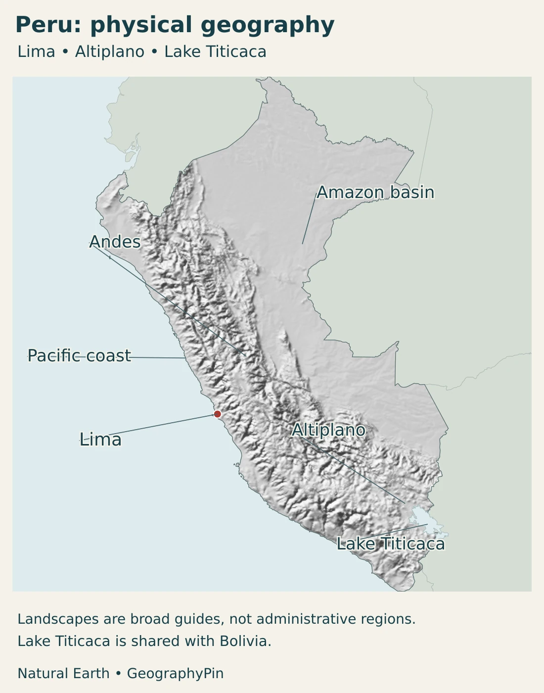
Map sources and scope: Original GeographyPin maps use public-domain Natural Earth country, city and lake geometry with its actual shaded-relief raster. A Lambert azimuthal equal-area projection centered at 10°S, 75°W keeps the country and its neighbors in one frame without relocated islands or separate-scale insets.
Lima’s dot represents the city location, not a metropolitan boundary. The Andes, Altiplano and Amazon labels indicate broad settings rather than surveyed regional or basin limits. Lake Titicaca is shown across its shared Peru–Bolivia setting. Neighboring land remains separate from Peru, and the maps do not draw maritime claims. Generalized coastlines and lake outlines are not navigation data or a current shoreline survey.
Relief shading depicts terrain form rather than numeric elevation classes. The original cover uses the red-white-red national flag, with a complete flag alongside its decorative outline. This civil flag does not carry a coat of arms. GeographyPin branding identifies the original composition.