Egypt’s outline tells only part of its story. A broad desert country contains a much narrower corridor of farmland, towns and transport routes beside the Nile, while its northeastern peninsula extends into Asia. Follow the river, the coastlines and the desert margins together to understand where people live and how the country connects to its neighbors.
Egypt lies mainly in northeastern Africa, with the Sinai Peninsula in Asia. The Nile flows north through a narrow valley before spreading into a delta beside the Mediterranean. Its water and irrigated land support the country’s main settlement corridor, surrounded by the Western and Eastern deserts. The Suez Canal connects the Mediterranean and Red seas.
How to use this article: Compare the main landscapes, untangle the capital and government-seat distinction, or see why settlement follows the Nile.
1. Locate Egypt between Africa and Asia
The Arab Republic of Egypt occupies Africa’s northeastern corner. Libya lies to the west and Sudan to the south. To the northeast, Egypt borders Israel and the Gaza Strip, part of the Palestinian territory. The Mediterranean lies along the north coast, while the Red Sea borders the east.
Most of the country is in Africa, but Sinai lies on the Asian side of the conventional continental division at the Isthmus of Suez. The peninsula sits between the Gulf of Suez to the west and the Gulf of Aqaba to the east. Those are different branches of the Red Sea, not two names for the same waterway.
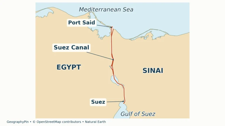
The Suez Canal crosses the isthmus between the Mediterranean and the Gulf of Suez. It is an artificial shipping route, not a branch of the Nile. This distinction separates two essential parts of Egypt’s geography: the Nile supplies freshwater and irrigated land, while the canal provides a maritime connection.
2. Country facts and the capital distinction
| Item | Reference |
|---|---|
| Capital and government seat | Cairo is the capital named in Constitution Article 222. The New Capital, east of Cairo, serves as a government seat; see the distinction below. |
| Population | 107,271,260: CAPMAS estimate as at January 1, 2025, reproduced in the Ministry of Finance’s October 2026 report. This is a dated estimate, not a live population-clock reading. |
| Reported surface area | 386,874 sq mi (1,002,000 km²), UN country-profile figure for 2023. This reported national statistic is separate from the generalized map footprint. |
| Official language | Arabic, under Constitution Article 2. |
| Currency | Egyptian pound (EGP). |
| First-level administration | 27 governorates, as listed in the October 2026 PCGN factfile. |
Population estimates from national and international series can differ because of their methods and coverage. The figure here retains the date and source of the CAPMAS estimate. The area is presented as the UN’s published surface-area measure, not as a new land survey or a calculation of the territory colored on these maps.
Cairo and the new government center
Cairo remains the capital named in Article 222 of the constitution. Meanwhile, government operations have moved to the purpose-built New Capital east of Cairo, formerly widely called the New Administrative Capital. The Ministry of Planning documented the start of operations from its new headquarters in March 2023, and the October 2026 PCGN reference identifies the New Capital as the government seat.
The distinction is legal status versus the location of working institutions. A ministry’s new address does not itself amend the constitutional capital provision, and moving government offices does not erase Cairo’s role as a major city. These are separate urban places, not two names for the historic Cairo center.
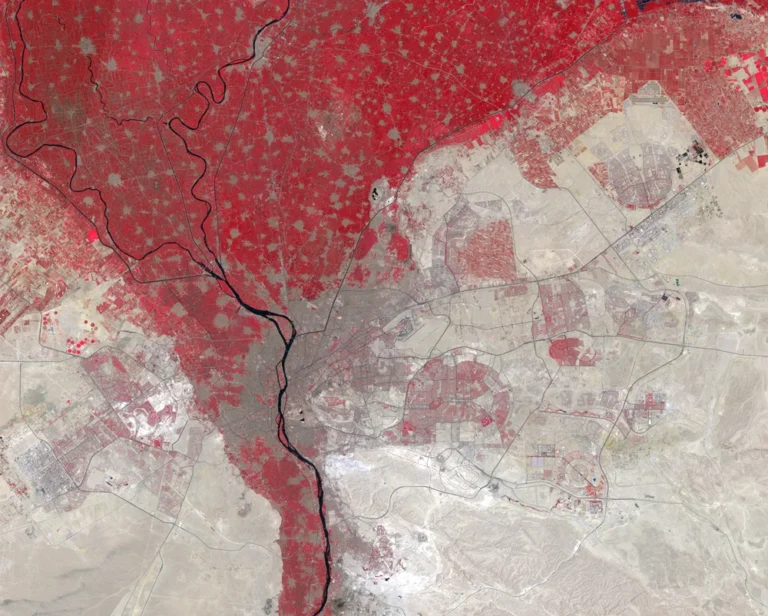
Cairo city, Cairo Governorate and Greater Cairo describe different geographic units. The wider urban region extends beyond the governorate and includes Giza across the Nile. A metropolitan population should not be presented as the population inside one administrative boundary. For the city’s position at the valley-to-delta transition, see the separate Cairo location guide.
3. Nile valley, deserts and Sinai
Four broad settings, not one uninterrupted sand sea
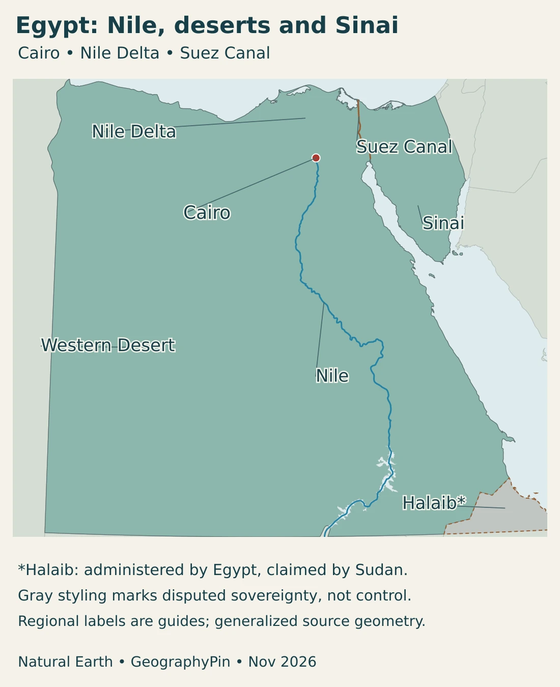
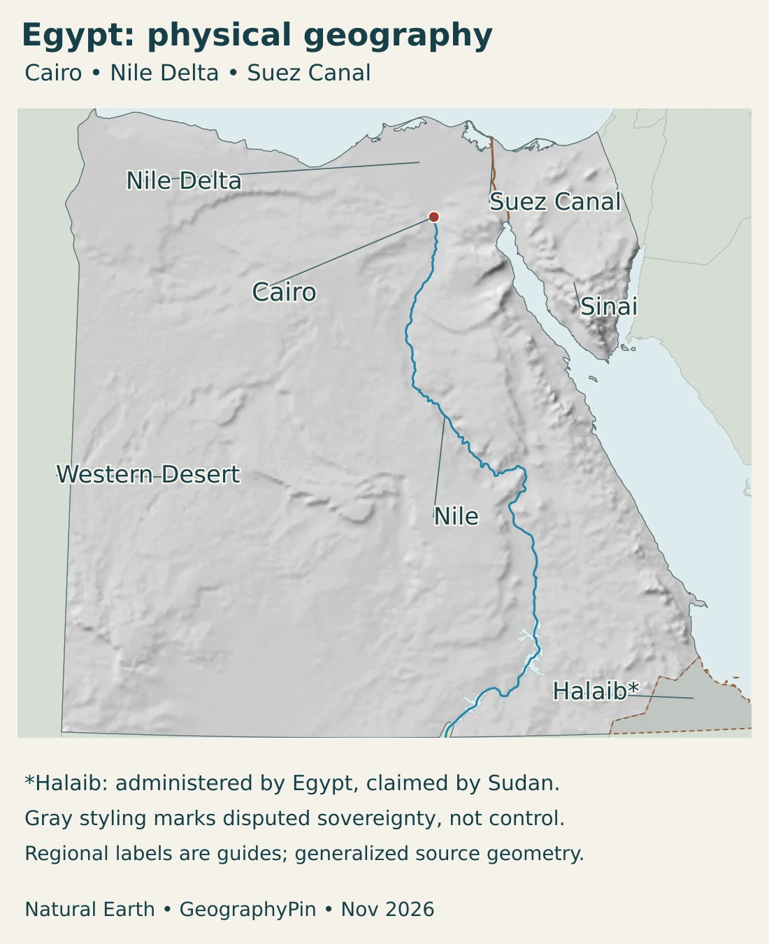
The Nile valley and delta, Western Desert, Eastern Desert and Sinai provide a useful first division of the country. They are physical settings rather than four administrative provinces. Their boundaries are generalized, and each includes smaller landscapes that a national overview cannot show in full.
| Setting | Where and what it is | Why it matters |
|---|---|---|
| Nile valley and delta | A north-flowing river corridor widening into a low plain toward the Mediterranean. | Irrigation, fertile soils and connected settlements concentrate here. |
| Western Desert | Desert plateaus, depressions, dunes and oases west of the Nile. | Groundwater supports scattered oasis communities, unlike the continuous river corridor. |
| Eastern Desert | Dry uplands and wadis between the Nile and the Red Sea. | Terrain separates the river valley from much of the coast and shapes routes across it. |
| Sinai Peninsula | The Asian peninsula between the gulfs of Suez and Aqaba, with high mountains in the south. | Coasts, northern plains and mountain interiors create distinct settings within one peninsula. |
South of Cairo, the Nile valley is comparatively narrow. Farther north, the delta broadens toward the sea, with branches, canals, cultivated land and settlements occupying its low plain. “Upper Egypt” means the upstream south; “Lower Egypt” means the downstream north. The terms follow the river rather than the top and bottom of a north-up map.
The Western Desert is not simply a surface of dunes. Plateaus and depressions interrupt its dry expanses, and oases such as Siwa, Bahariya, Farafra, Dakhla and Kharga support communities using groundwater. Their cultivated patches illustrate a different relationship with water from farming beside the Nile.
Geology also makes the desert more varied than its name suggests. At Wadi Al-Hitan, fossil whales preserved in exposed rocks record a marine environment and the evolutionary transition toward fully aquatic whales. A landscape that is desert today can preserve evidence of a very different ancient environment.
On the other side of the Nile, the Eastern Desert rises toward the Red Sea uplands. Sinai has its own combination of coastal land, interior plateaus and southern mountains. Its mountainous south can experience winter cold, so “Egypt is desert” does not mean that every place has the same temperature or relief.
4. Climate and the working river system
Dryness is widespread, but seasons and terrain still matter
Egypt is predominantly arid. The Mediterranean coast receives more rain than much of the interior, with rainfall concentrated in the cooler part of the year. Farther south and across much of the Western Desert, rain is rare. Elevation creates another contrast: high southern Sinai is cooler than nearby low coastal settings, especially in winter.
These differences do not make the Nile valley a naturally wet climate zone. Much of its greenery depends on managed water rather than abundant local rainfall. A cultivated field beside an irrigation canal and bare desert nearby can share essentially the same regional climate.
The Nile is a cross-border river, not a local rainwater channel
The Nile brings water into Egypt from a much larger upstream system. Its flow cannot be explained by rain falling inside Egypt alone. The Nile river guide follows the wider basin and its main branches; the country profile focuses on the river’s role within Egypt.
Near Aswan, the High Dam stores water in Lake Nasser and regulates releases downstream. Storage supports water management and hydroelectric generation, while also changing the river’s sediment transport. Much of the sediment that once traveled farther downstream is retained behind the dam.
The dam’s benefits and downstream consequences belong in the same explanation. Flood regulation does not mean that the river has stopped functioning, and a green delta does not mean that fresh sediment still arrives as it did before major regulation. Coastal erosion and saltwater intrusion are among the pressures affecting the delta.
Why farmland and the coast need careful management
Irrigation makes intensive cultivation possible in the valley and delta, including field crops, vegetables and fruit trees. It also makes water distribution, drainage and soil condition central to agricultural production. Expanding cultivated land into desert settings requires a water supply and continuing management, not just clearing an empty area on a map.
At the low-lying Mediterranean margin, sea-level rise and saltwater intrusion create additional risks for land, water and infrastructure. These pressures interact with river regulation and development. They are not a prediction that every part of the delta will disappear at the same time, nor do they affect every coastal community identically.
5. People, cities and languages
Why population follows the valley and delta
The settlement pattern begins with access to water and cultivable land. The Nile corridor offered conditions for farming and communication that the surrounding arid landscapes did not provide on the same continuous scale. Towns, roads and economic activity accumulated along that corridor, reinforcing its importance over time.
This is concentration, not an assertion that nobody lives elsewhere. Oasis communities, coastal towns and desert-edge development belong to the modern country too. Their water sources, infrastructure and economic functions differ from those of established river settlements.
Cairo stands near the transition from the valley to the delta. Alexandria faces the Mediterranean, while cities along the Nile connect the southern valley with the north. Port Said and Suez serve the canal’s two ends. These positions help distinguish a river metropolis, a Mediterranean port and canal cities without reducing them to one identical urban role.
Urban expansion also creates competition for space near productive land. Building on desert margins can change where people live, but housing alone does not create an independent water supply or remove the need for transport, jobs and services. The older river-centered pattern and newer planned development therefore need to be read together.
Language and public life
Arabic is the official language. Modern Standard Arabic is used in formal writing, while spoken varieties include Egyptian Arabic and regional forms. Legal language status and the language someone uses in everyday conversation are related but not identical questions. The Arabic script also explains why a place can appear in more than one Roman-letter spelling without being a different location.
6. Government and economic geography
Egypt is a republic with a president, a prime minister and a national government. Governorates organize first-level territorial administration; they are not independent countries. The physical regions used in this article cross or encompass administrative boundaries, so the Nile Delta and Western Desert should not be mistaken for governorates.
Egypt’s economic geography combines irrigated agriculture, urban services and industry, maritime trade and tourism. These activities depend on different kinds of location. Farming is closely tied to water and suitable soils; shipping depends on the canal and ports; historic sites and coastal environments support different forms of tourism.
The Suez Canal is a sea-level waterway connecting the Mediterranean and Red seas, allowing ships to pass between these maritime regions without sailing around Africa. Its value comes from that position in international routes. Canal income is not a fixed geographic constant: traffic and revenue can change with trading conditions and disruptions farther along the route.
The country’s inland economy should not be overlooked beside the globally visible canal. The Nile valley and delta are also settings for production, markets and everyday travel. Water management links agriculture to cities, and decisions about urban growth affect land and infrastructure well beyond the boundaries of a single new development.
Frequently Asked Questions
Is Egypt in Africa or Asia?
Most of Egypt is in northeastern Africa. The Sinai Peninsula lies in Asia under the usual continental convention. The country therefore spans both continents, with the Suez isthmus and canal marking the commonly used division.
Why do so many people live near the Nile?
Water, irrigated farmland and a long-established network of settlements and transport concentrate in the valley and delta. Much of the surrounding land is arid. Oases, coastal towns and newer desert developments are important exceptions, not evidence that the river corridor has lost its central role.
Does the Suez Canal carry Nile water to the Red Sea?
No. The Suez Canal is a sea-level shipping waterway between the Mediterranean and the Red Sea. It is not a Nile distributary. The Nile flows north toward its Mediterranean delta and belongs to a different water system.
What Did We Learn Today?
Egypt’s geography brings together a densely settled river corridor, large desert regions and an Asian peninsula. The Nile explains much of the relationship between water, farming and settlement, while the Suez Canal explains a different connection through maritime trade. Regional climate, groundwater, mountain terrain and coastal pressures make the country more varied than a single desert label suggests.
Sources & Data Notes
- Ministry of Finance — October 2026 economic report. Table 15 reproduces the CAPMAS population estimate of 107,271,260 as at January 1, 2025. The report’s publication month is not the population reference date.
- United Nations Statistics Division — Egypt profile. Reported surface area of 1,002,000 km², dated 2023 in footnote b; Egyptian pound. The population table above uses the separately identified CAPMAS series.
- Ministry of Finance — Constitution of Egypt. Articles 1, 2 and 222 support the republican framework, Arabic’s official status and Cairo’s constitutional capital designation.
- Ministry of Planning — new headquarters operations. March 15, 2023 announcement documenting operational relocation to the new government district.
- UK Permanent Committee on Geographical Names — Egypt, October 2026. Current place-name reference, government-seat distinction, 27 governorates, language usage and border context. Country statistics in this article retain their separately identified sources.
- Egypt Desert Research Center — National Action Plan 2024–2030. Physical and climatic settings, groundwater-supported Western Desert oases, land management and the concentration of activity in the Nile valley and delta; especially pages 29–30 and 43–44. Regional descriptions are broad settings, not newly surveyed boundaries.
- FAO — water productivity and nutrition in Egypt. Irrigation and crop cultivation concentrated in the valley and delta.
- FAO — SCALA Egypt country overview. Coastal exposure to inundation and saltwater intrusion, and the connection between water, agriculture and adaptation.
- NASA — Aswan High Dam and Lake Nasser. Historical image interpretation explains storage, power generation, flood regulation and sediment trapping. It is not a current reservoir-level measurement.
- Suez Canal Authority — About Suez Canal. The artificial sea-level route between the Mediterranean and Red seas, its endpoints and shipping function.
- UNESCO — Wadi Al-Hitan. Fossil whale remains and their geological and evolutionary significance in today’s Western Desert.
Map sources and scope: Original GeographyPin maps use public-domain Natural Earth country, city, river, canal, lake and disputed-area geometry with its actual shaded-relief raster. All mapped land shares one Lambert azimuthal equal-area projection centered at 27°N, 30°E; Sinai is not relocated into an inset.
The Halaib/Halayib Triangle is styled neutrally to distinguish Egyptian administration from Sudan’s claim. Bir Tawil retains separate neutral source geometry on the maps and is excluded from the cover’s colored outline. These are generalized geographic illustrations, not adjudications of sovereignty or surveys of current military control. The October 2026 PCGN reference describes the border context.
Cairo’s dot marks the city, not the extent of its metropolitan area or a claim that all government offices remain there. Waterway lines are generalized source features, not current navigation charts or complete inventories of canal expansions and delta branches. Landscape labels identify broad settings without measured regional boundaries. Relief depicts terrain form, not elevation classes. November 2026 on the maps is the artwork-preparation date, not a new boundary survey.
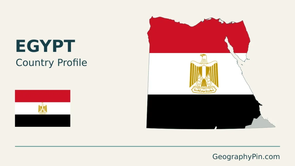
The original cover uses the Egyptian flag, with its eagle preserved in the separate intact flag. GeographyPin branding identifies the original composition.