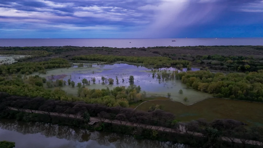
Buenos Aires looks across a vast expanse of water, yet its waterfront is not a straightforward Atlantic beachfront. The city stands beside the Río de la Plata, where continental drainage meets marine influence. Its name also belongs to a separate province, making both the physical setting and the administrative map worth reading carefully.
Buenos Aires lies on the western shore of the Río de la Plata in east-central Argentina, at the edge of the Pampean plain. The autonomous city, known as CABA, is Argentina’s capital and is separate from Buenos Aires Province. The wider metropolitan region extends into the province, while the estuary links the Paraná–Uruguay river system with the Atlantic.
Read the city at the right scale: Start with the estuary, explore the Pampas landforms, separate city, province and metropolitan region, or examine the changing waterfront.
1. Where is Buenos Aires?
Buenos Aires is on the Argentine side of the Río de la Plata, opposite Uruguay across the water. Its landward surroundings belong to Buenos Aires Province, while the Matanza–Riachuelo forms the city’s southern river boundary before entering the Río de la Plata.
The wider setting combines a low-relief continental plain, river valleys and an estuarine coast. The city is therefore connected to places far upstream through water and sediment movement, not only to the water visible from its shoreline.
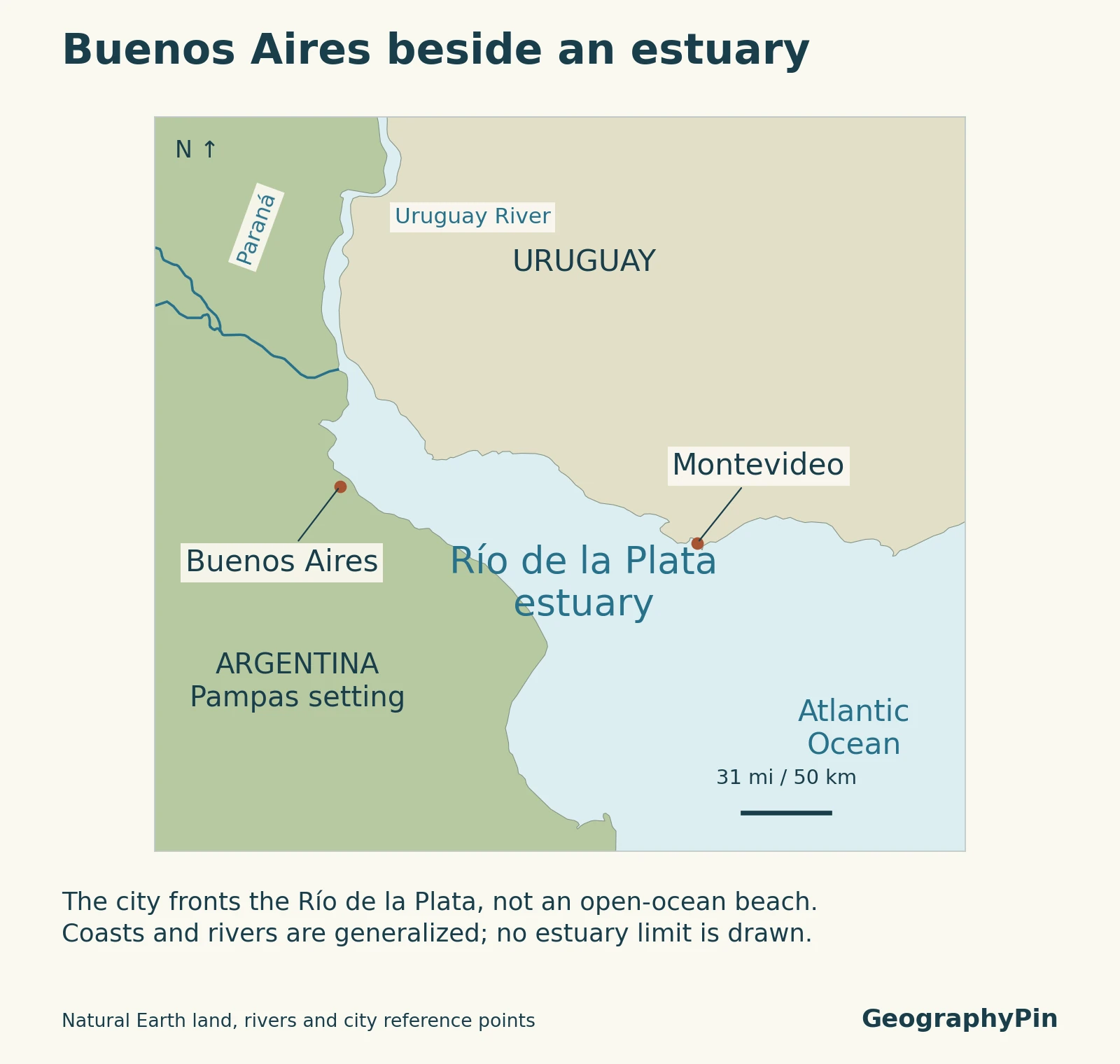
Two maps answer two different questions. The estuary locator shows Buenos Aires in relation to the water system and neighboring country. The administrative comparison later in the article separates the autonomous city from the province sharing its name.
2. The Río de la Plata estuary
A river–estuary system, not one uniform body of water
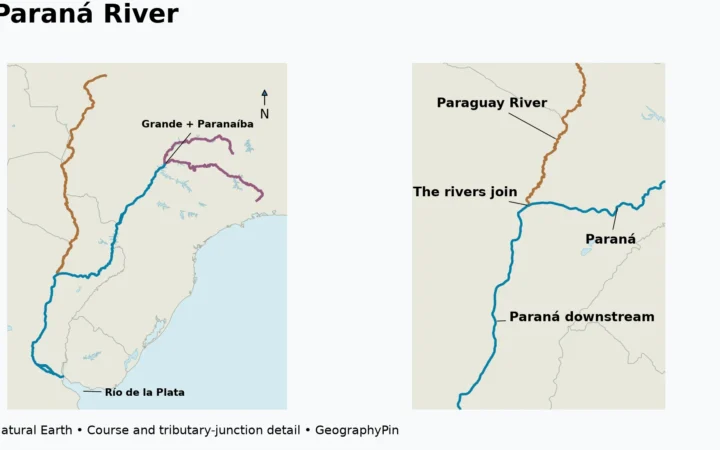
The Río de la Plata receives the Paraná and Uruguay river systems and opens toward the Atlantic. Calling it an estuary emphasizes the interaction between river discharge and marine water. Its broad appearance from shore does not make every part an open-ocean environment.
The Río de la Plata Administrative Commission describes a system in which relatively fresh water moves seaward near the surface while denser marine water can enter underneath. Salinity, circulation and mixing vary across the system and through time. A statement that the whole Río de la Plata is always fresh, or always salty, would hide that variation.
Argentina’s space agency, CONAE, also describes an estuarine front whose location changes with discharge and wind. The boundary between different water masses is not a permanent line that can be copied from an administrative map. Nor should the legal limits of the Río de la Plata be read as a salinity boundary.
River-borne sediment contributes to the water’s turbidity. The inner estuary can look brown or opaque because material remains suspended in the water. Color alone does not reveal salinity, water quality or whether a particular place is suitable for swimming.
This connection between rivers, coast and ocean is a useful example of physical geography: land and water processes continue across borders, even when different governments manage the adjoining shores.
3. The Pampas beneath the city
Low relief does not mean an entirely level surface
Buenos Aires belongs to the Pampean plain, a regional landscape rather than a municipal boundary. The city’s official geographic synthesis places it in the southern part of the higher Pampa Ondulada, or rolling Pampas.
That setting includes gently rolling surfaces formed in fine, loess-like sediment, valleys cut by streams, and lower ground toward the Río de la Plata. These differences are subtle compared with mountain terrain, but they matter for drainage and the way the city occupies its site.
Much of the natural drainage is difficult to see from a street. Streams such as the Maldonado, Vega and Medrano have been enclosed in urban infrastructure. The absence of an open channel does not mean its catchment has disappeared: rainfall still follows the land and drainage network toward an outlet.
The Maldonado also illustrates why a city boundary is not a watershed boundary. Its course begins in provincial municipalities before passing through CABA and reaching the Río de la Plata. Water arriving in a city district can therefore be connected to conditions outside the autonomous city.
4. City, province and metropolitan boundaries
Three names with different geographic meanings
| Name | Meaning |
|---|---|
| Autonomous City of Buenos Aires (CABA) | Argentina’s national capital and a separate autonomous jurisdiction. |
| Buenos Aires Province | A separate province, extending far beyond the metropolitan area; its capital is La Plata. |
| Buenos Aires metropolitan region | A wider urban or statistical region combining CABA with surrounding provincial territory; the definition must be specified. |
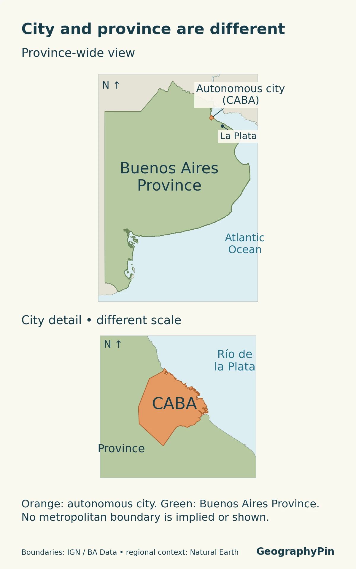
CABA contains 48 neighborhoods grouped into 15 communes. These subdivisions are inside the autonomous city; they are not the same units as the province’s partidos, or municipal districts.
The province is not simply the city’s suburban ring. It includes other cities and extensive territory well beyond the metropolitan setting. La Plata, not CABA, serves as the provincial capital. Keeping that distinction prevents a common mistake when reading an address, population total or map label.
Metropolitan terminology requires another check. INDEC’s Región Metropolitana Buenos Aires (RMBA) uses CABA plus 39 partidos. A national-government AMBA coordination definition lists CABA plus 40 municipalities. These are stated institutional definitions, not interchangeable counts of one universally fixed area.
For that reason, an unlabeled “Greater Buenos Aires” outline or population total is incomplete information. The source should identify its member areas or statistical definition. The maps here distinguish the city and province without inventing a single metropolitan boundary.
5. Coastal change and floodplain context
Reclaimed land and water-level changes shape the waterfront
Parts of the Buenos Aires waterfront are the result of deliberate coastal modification. Costanera Sur provides a clear example: rubble began to be deposited along the shore in 1978 for a proposed administrative-center development. After the project was abandoned, vegetation colonized the fill, contributing to the landscape later protected as an ecological reserve in 1986.
The reserve is therefore neither an untouched remnant of an unchanging coastline nor simply a landscaped city park. Its history combines engineered land creation and subsequent ecological development. A present-day shoreline should not be assumed to mark the same edge shown on older maps.
Water levels can change for reasons beyond local rainfall. A sudestada brings strong southeasterly winds that can raise levels in the Río de la Plata and affect low-lying coastal areas. The estuary’s response also depends on discharge, tides and its physical configuration.
Urban rainfall and drainage add their own pressures. Enclosed streams, outlets and low ground belong to a connected system, so coastal water levels and inland drainage cannot always be considered independently. This broad explanation is not a flood-risk classification for any address.
For current conditions, use official city weather advisories and water-level information rather than this geographic overview. A map showing a river or an administrative boundary does not establish flood depth, safe access or the likelihood of an individual property being affected.
6. Key facts and measurement notes
| Jurisdiction | Total population |
|---|---|
| Autonomous City of Buenos Aires | 3,121,707 |
| Buenos Aires Province | 17,523,996 |
These are INDEC’s final 2022 Census totals, as presented in its REDATAM universe-control table. They are not current population estimates. The province’s number does not include CABA, and neither row by itself is a metropolitan-region total.
Population in private dwellings is a different measure from total population. For example, the same official table gives a smaller private-dwelling count for CABA. Mixing those categories can create an apparent discrepancy where there is only a difference in coverage.
The same care applies to areas and maps. A city perimeter, a province boundary, the built-up urban footprint and a river basin represent different things. Before comparing figures, match the geographic unit, reference date and type of measurement.
Frequently Asked Questions
Are the Matanza River and the Riachuelo two unrelated rivers?
No. They are names used along the connected Matanza–Riachuelo watercourse. The lower reach is commonly called the Riachuelo; it forms Buenos Aires’ southern river edge and flows into the Río de la Plata. It is not another name for the Río de la Plata itself.
What Did We Learn Today?
Buenos Aires occupies the meeting place of the rolling Pampas and the Río de la Plata river–estuary system. Its waterfront has changed through reclamation, while winds, river discharge and drainage influence water conditions. CABA, Buenos Aires Province and metropolitan definitions cover different areas; a useful map or population figure must say which one it represents.
Sources & Data Notes
The population table uses final 2022 Census totals for two separate jurisdictions. Metropolitan conventions are attributed explicitly rather than treated as a universal boundary. The estuary locator does not represent salinity, navigational channels, flood probability or property boundaries.
Map method: The locator uses public-domain Natural Earth coastlines, rivers and reference points. The comparison uses Buenos Aires Province geometry from Argentina’s IGN and the official BA Data city perimeter. IGN’s metadata allows attribution-licensed reuse; the city dataset is licensed CC BY 2.5 Argentina. Inputs differ in scale and vintage. These are general geographic comparisons, not cadastral surveys, current reclamation boundaries or metropolitan-area delineations. No area or population was calculated from the map shapes.
Featured photograph: Buenos Aires waterfront and estuary, ProtoplasmaKid, September 29, 2025. Resized and converted; the adapted photograph remains available under CC BY-SA 4.0.
- Buenos Aires City: geographic overview: Location and city subdivisions.
- Río de la Plata Administrative Commission: environment: Circulation, salinity and water-level influences.
- CONAE: the estuarine front: Turbidity and a changing river–marine interface.
- Dinámica de una ciudad: Buenos Aires, 1810–2010: Pages 25–26: Pampean landforms and city terrain.
- Buenos Aires City: rivers, streams and catchments: Enclosed streams and the Matanza–Riachuelo relationship.
- Buenos Aires Province: La Plata: La Plata’s provincial-capital role.
- INDEC: regional definitions: RMBA convention, CABA plus 39 partidos.
- Argentina: AMBA coordination area: A separately stated 40-municipality convention.
- INDEC: 2022 Census universe-control tables: Table 3, page 5: final total population by jurisdiction.
- Buenos Aires City: Costanera Sur history: Reclamation, colonization and reserve designation.
- Buenos Aires City: sudestada guidance: Southeasterly winds and raised coastal water levels.