A search for Hawksbill Mountain can lead to two very different destinations. One rises in Virginia’s Shenandoah National Park; the other overlooks North Carolina’s Linville Gorge. The shared name is easy to recognize, but the state, landscape, and official route information are what keep the places separate.
Hawksbill in Virginia is Shenandoah National Park’s highest summit, at 4,051 feet (about 1,235 meters). Hawksbill Mountain in North Carolina overlooks Linville Gorge in Pisgah National Forest; Burke County Tourism lists it at 4,009 feet (about 1,222 meters). They are separate places with different approaches and official visitor information.
Find your Hawksbill: Start with the two locations, compare published elevations, or go to the official route resources.
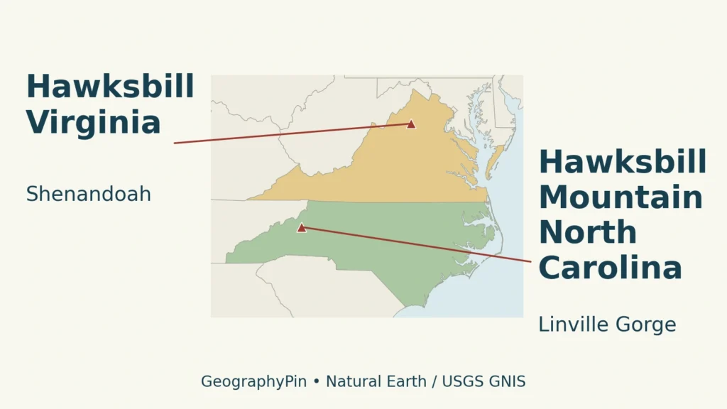
1. Two Hawksbill locations on the map
The two mountains compared here are in different states. The Virginia summit is in Shenandoah National Park. The North Carolina mountain overlooks Linville Gorge in Pisgah National Forest. They are not alternative entrances to one mountain, and a trail description for one cannot be transferred to the other.
The map separates their positions before comparing their heights or views. State outlines provide regional context; the dots identify named features rather than the extent of a park, forest, or trail system. A summit point also does not identify where to park.
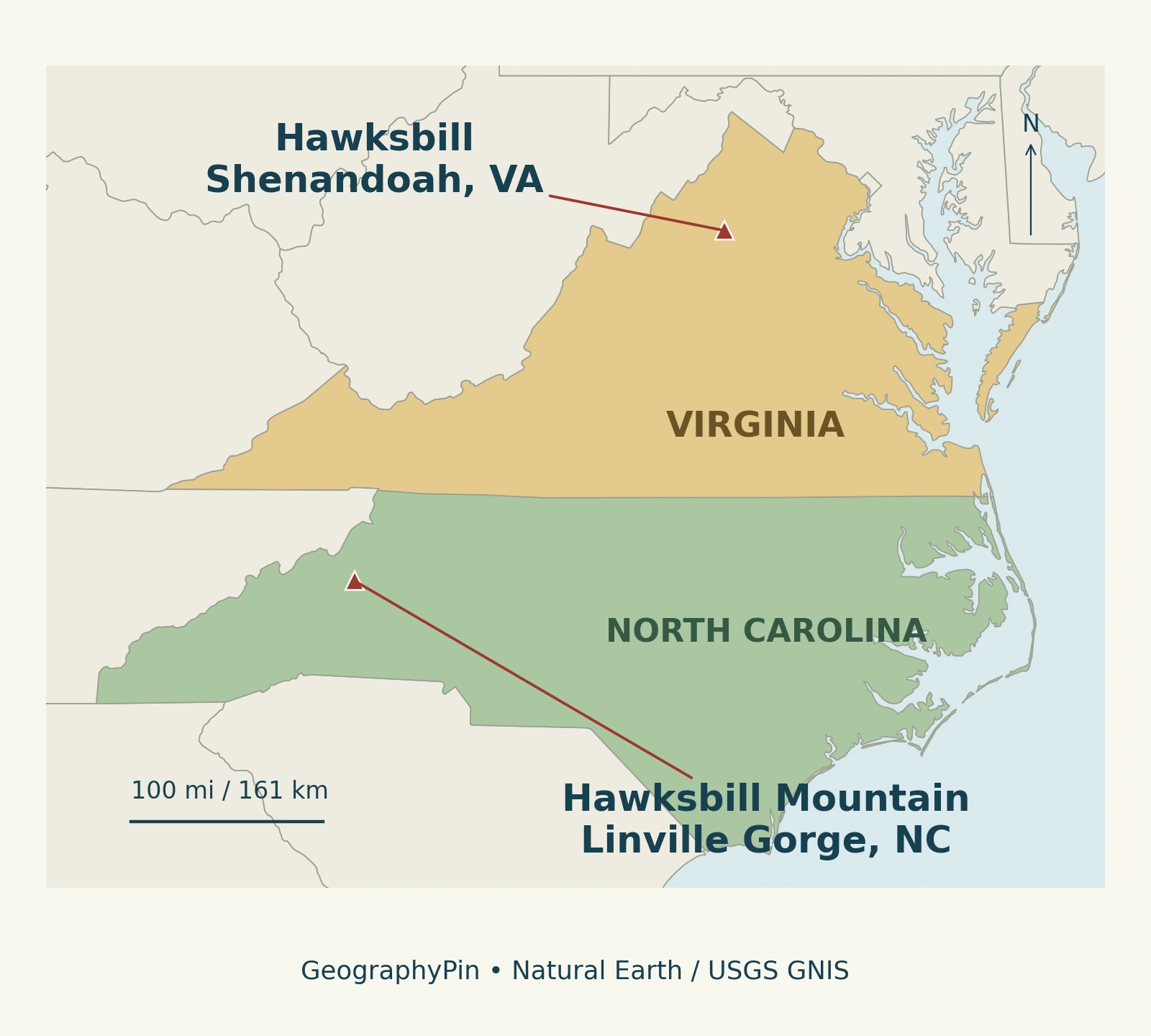
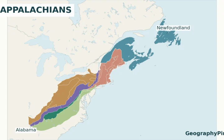
Both belong to the broader Appalachian mountain region. The Appalachian Mountains map gives the larger context, while the comparison below keeps the two local settings distinct.
2. Compare the state, setting and elevation
| Feature | Virginia | North Carolina |
|---|---|---|
| Location | Shenandoah National Park | Linville Gorge, Pisgah National Forest |
| Mountain setting | Blue Ridge | Jonas Ridge, eastern side of Linville Gorge |
| Published summit elevation | 4,051 feet (about 1,235 meters) | 4,009 feet (about 1,222 meters) |
| Elevation source | National Park Service | Burke County Tourism |
| Official visitor information | National Park Service | U.S. Forest Service |
| Landscape to recognize | Shenandoah Valley and Blue Ridge views | Rocky summit above the Linville Gorge landscape |
These are published summit elevations, not fresh survey measurements. Metric equivalents are rounded to the nearest meter. The figures are useful for identifying the mountains, but their small difference is not a useful guide to how demanding a particular walk will feel.
A summit’s elevation measures its height above sea level. Elevation gain measures the ascent along a route, and local relief describes the height difference within a landscape. A trail can start high on a mountain, so its climbing distance is not the same number as the summit elevation. Our physical geography explainer places landforms and their relationships in a wider context.
3. Virginia: the highest summit in Shenandoah
The National Park Service: Shenandoah park statistics identifies Hawksbill as Shenandoah National Park’s highest point. That is a park-specific distinction, not a claim that it is the highest mountain in Virginia or the entire Appalachian system.
The National Park Service: Hawksbill Summit describes a summit viewing platform looking across the Shenandoah Valley, Blue Ridge Mountains, and Virginia Piedmont. Those names are useful clues when identifying a caption or route description: they refer to the Virginia setting rather than the North Carolina gorge.
For the Lower Hawksbill route, the park identifies Hawksbill Gap parking on Skyline Drive at mile 45.5. Choose the official route map for the intended starting point rather than navigating toward a summit coordinate alone.
The park also links information about limited closures protecting sensitive summit outcrop ecosystems. A viewing platform does not make every nearby rock surface an unrestricted visitor area. Follow the current park notices and signs rather than assuming every visible path or exposed ledge is an authorized route.
4. North Carolina: a summit above Linville Gorge
North Carolina’s Hawksbill Mountain belongs to the Linville Gorge setting in Pisgah National Forest. The U.S. Forest Service: Linville Gorge Wilderness describes Jonas Ridge on the gorge’s east and Linville Mountain on its west, with the Linville River between them. Hawksbill is one of the named high points on the Jonas Ridge side.
Here the useful landscape relationship is mountain, ridge, and gorge. A ridge is an elongated high area; a summit is a particular high point along a mountain landscape; a gorge is the deeply cut valley below. Calling all three “Hawksbill” obscures what a map is showing.
Burke County Tourism: Hawksbill Mountain gives the summit elevation as 4,009 feet and describes views over Linville Gorge. That is the source of the North Carolina figure used here. It should not be replaced with a general elevation displayed for the wider wilderness area, which may refer to a different location.
The Forest Service’s older Linville Gorge brochure places Hawksbill among the features on Jonas Ridge, alongside names such as Table Rock and Sitting Bear. Those are separate features, not other names for Hawksbill. Historical brochures can help explain the landscape, but current access information should come from the present Forest Service pages.
5. Choose the correct official route information
Start with the state and land-management unit, then choose the trail. This order matters more than matching a photograph of a rocky overlook. A scenic image with only “Hawksbill” in its caption does not reliably identify which mountain it shows.
- For Virginia: use the National Park Service’s Hawksbill Summit information and linked Shenandoah trail map. Check the intended starting point, park alerts, and current access arrangements.
- For North Carolina: use the U.S. Forest Service: Hawksbill Trail and the Linville Gorge Wilderness information. The agency identifies Hawksbill Trail as trail 245, beginning on Forest Service Road 210 and leading to the mountain’s summit.
The Forest Service describes Linville Gorge’s terrain as steep and rugged and warns that wilderness trails may lack the signs and markings visitors expect. A regional locator like the one above is not adequate for choosing a route through that terrain. Use a suitable detailed map and current official information.
Road construction, storm damage, restrictions, and weather can change independently of a mountain’s name or position. A page describing a trail does not, by itself, confirm that every approach is open today. The linked agencies are the appropriate sources for those changing details; this comparison does not provide a live access report.
Frequently Asked Questions
Why do maps use both “Hawksbill” and “Hawksbill Mountain”?
The USGS Geographic Names Information System records the Virginia summit as “Hawksbill” and the North Carolina summit as “Hawksbill Mountain.” Visitor descriptions may add or omit “Mountain,” so that word alone is not a reliable identifier. Check the state and surrounding park or forest as well.
Is Hawksbill Gap the same thing as Hawksbill’s summit?
No. In the Virginia route description, Hawksbill Gap is associated with the parking area and trail approach. A gap is a low passage or saddle in a ridge; a summit is a high point. Selecting the gap or the summit in a mapping app therefore answers different navigation questions.
What Did We Learn Today?
The state and surrounding landscape resolve the Hawksbill name: Shenandoah in Virginia, Linville Gorge in North Carolina. Summit elevation, trail ascent, and a parking location describe different things. Keeping those distinctions clear makes maps, photographs, and official visitor information much easier to use.
Sources & Data Notes
The elevations follow the National Park Service for Virginia and Burke County Tourism for North Carolina. Feet were converted using 0.3048 meters per foot and rounded to whole meters. No new survey or harmonized elevation dataset is implied. The original map uses USGS GNIS summit points (Virginia ID 1467849; North Carolina ID 1011920) and Natural Earth state outlines; it does not show park boundaries, trail alignments, or current closures. The map uses an equirectangular display centered on 37°N with an approximate regional scale. Natural Earth data are public domain. The featured image is a wider composition using the same source data and summit locations.
The Forest Service’s 2009 Linville Gorge brochure supports stable ridge-and-landmark relationships only. Its historical operational details are not used as current guidance.