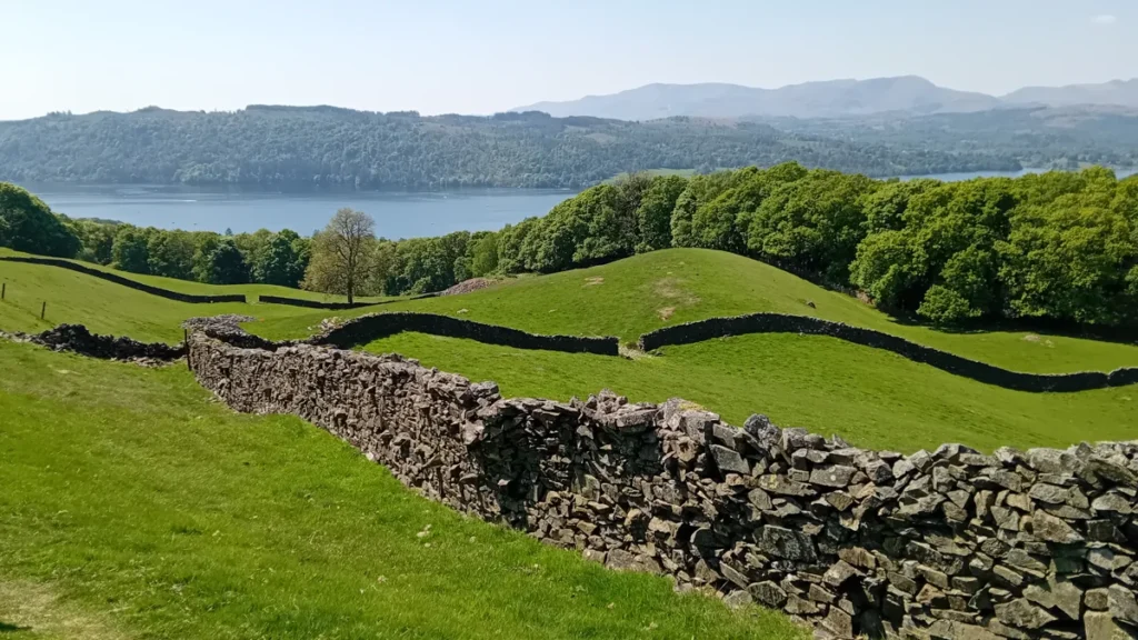
Dry stone walls shape the Lake District because they turn local stone into lasting farm boundaries without mortar. They divide fields, contain livestock and record generations of land management. Their materials and forms vary with local geology and building traditions. Gates and stiles provide crossings, but a stile alone does not grant access to every adjoining field.
The walls winding across the Lake District are not simply scenery around its lakes. They are working structures in a landscape shaped by both natural processes and farming. Look closely and a wall can reveal its construction, its relationship to a field and the point where a path crosses it. What it cannot reveal at a glance is its exact age or the legal status of the land beyond.
How to use this article: Explore why a boundary can be older than its stones, look inside a typical wall cross-section, or check what a stile means for access.
1. What is a dry stone wall?
A dry stone wall is built by fitting stones together without mortar or cement. “Dry” describes the construction method, not the weather or whether the stones are wet. Stability comes from how the stones are selected, supported and arranged, rather than from a binding paste between them.
The Dry Stone Walling Association describes these walls as practical livestock boundaries as well as heritage features. They can also shelter animals and provide spaces for plants and small wildlife. A wall is therefore more than a line drawn across a view: it has a structure and a continuing role in the countryside.
This does not make every wall identical or maintenance-free. Poorly supported stones, damaged sections and loss of material can compromise a structure. Regional styles differ, and a partly repaired wall should not be treated as a universal example of how all walls were originally built.
2. Field boundaries and farming history
The English Lake District lies in northwest England. Glaciers shaped its valleys and basins; people subsequently organized much of that terrain into a farming landscape. UNESCO’s World Heritage description emphasizes this combination of natural landforms and agricultural use, including fields enclosed by walls. It does not describe the Lake District as untouched wilderness.
The Lake District National Park identifies medieval ring garths, walls separating cultivated valley land from open fell, and later enclosed intakes extending beyond them. These patterns help explain why walls occur at different positions between valley bottoms and higher slopes. A field wall may be part of a much longer history than its present appearance suggests.
A boundary’s age is not the age of every stone
Some boundary lines have medieval origins, while other walls reflect later enclosure and land management. Repairs and rebuilding can preserve an old line with newly arranged or replacement stone. Consequently, “medieval boundary” and “unchanged medieval wall” are not equivalent claims.
The DSWA notes the importance of eighteenth- and nineteenth-century field walls across Britain. That broader history should not be simplified into a claim that every Lake District wall dates from that period. Identifying one wall’s history requires local records, historic maps or archaeological evidence, not a guess based on moss, color or a dramatic photograph.
3. Local stone and wall structure
Available rock influences a wall’s color, texture and shape. The National Park describes local materials including slate, limestone and granite in the built landscape. Flat, irregular or rounded stones present different choices to a waller; the result is not one standard pattern repeated throughout the region.
Local material also need not match the bedrock immediately beneath a wall. The British Geological Survey’s Keswick district account records both locally quarried rock and glacial erratics used in dry stone walls. Ice can transport stones, and people can collect or quarry them. A wall is therefore a useful geological clue, but not a substitute for identifying its stones.
A typical double-faced wall
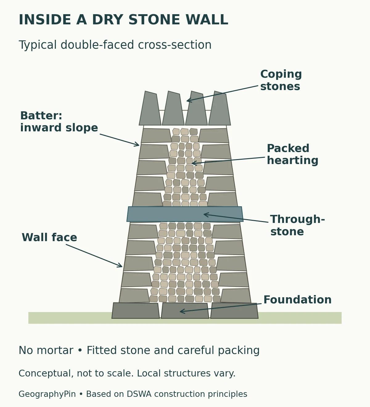
In this example, a broad foundation supports two faces that slope inward as the wall rises. That inward slope is called the batter. Smaller stones, known as hearting, are carefully packed inside. A through-stone extends across the wall to help tie its faces together. Coping stones finish and weight the top.
The diagram explains the relationship between parts, not a recipe for repairing a real wall. Dimensions, stone selection and details require appropriate craft knowledge. Projecting stones are not automatically steps: some are structural through-stones. Use a designated crossing rather than climbing wherever a foothold seems convenient.
4. Stiles, gates and public paths
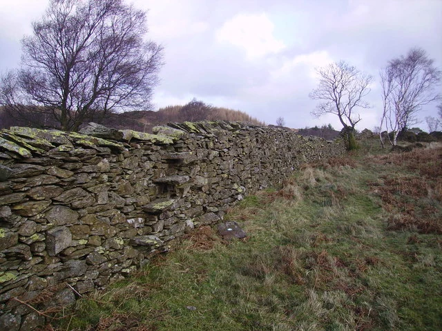
A stile allows people to cross a boundary while the surrounding wall continues its enclosing function. Some stiles use stone steps projecting from the wall; others use a different arrangement. A gate creates an opening that can be closed. These features reconcile movement through the countryside with the practical need to manage livestock and fields.
A crossing is not blanket permission
A stile’s existence does not, by itself, establish a public right of way or permission to wander across neighboring fields. Check the mapped route, local signs and current access information. England’s open-access rules allow wider access on certain land, but they do not turn every field, garden or farm building into public space.
The Countryside Code advises staying on marked paths unless wider access is available, and using gates, stiles or gaps rather than damaging boundaries. Leave gates as you find them or follow posted instructions. If a crossing is unsuitable for someone in your group, plan an appropriate alternative route rather than assuming any part of the wall can safely be climbed.
5. How to read a wall in the landscape
Begin with what you can actually see. Follow the wall’s alignment across the field, notice where it meets a path, and compare the stones without removing or disturbing them. Then separate observation from interpretation.
| Visible feature | Useful observation | Do not assume |
|---|---|---|
| A continuous wall dividing land | It organizes space into separate areas. | The exact legal ownership boundary or date. |
| Different stone shapes | Material and building choices vary. | Every stone came from the bedrock below. |
| Steps or a gate | A crossing has been provided. | Unrestricted access to surrounding land. |
| A repaired section | The structure has been maintained. | The whole boundary is equally recent. |
The lakes and the walls tell different parts of the same landscape story. To explore the water bodies themselves, start with what a lake is and how lakes form. On a walk, the most revealing question is often not “How old is this stone?” but “What is this boundary doing here?”
What Did We Learn Today?
Lake District walls connect geology, craft and farming history. Their fitted stones make useful boundaries, while repairs carry older patterns into the present. Looking at their construction helps explain the landscape, but appearance alone cannot date a wall, identify every rock or establish access rights. Stiles and gates are crossings to use responsibly, not invitations to ignore the working countryside around them.
Sources & Data Notes
The diagram is an original conceptual illustration based on DSWA construction principles, not a survey or repair specification. Historical boundary patterns do not establish the age of every surviving stone. Access advice concerns England; consult current maps and local notices for a particular route.
- DSWA: Dry Stone Walls – A Part of Our Heritage.
- DSWA: Life of a Dry Stone Waller, for wall anatomy and craft principles.
- Lake District National Park: special qualities, for ring garths, intakes and local materials.
- UNESCO: The English Lake District, for the cultural-landscape context.
- British Geological Survey: Geology of the Keswick district, construction-materials section.
- The Countryside Code and GOV.UK: open-access land.
Featured photograph: TheMaverickMan, Lake District – Dry Stone Walls & Lake Windermere, CC BY-SA 4.0. Cropped, resized and converted to WebP. The image retains that license.