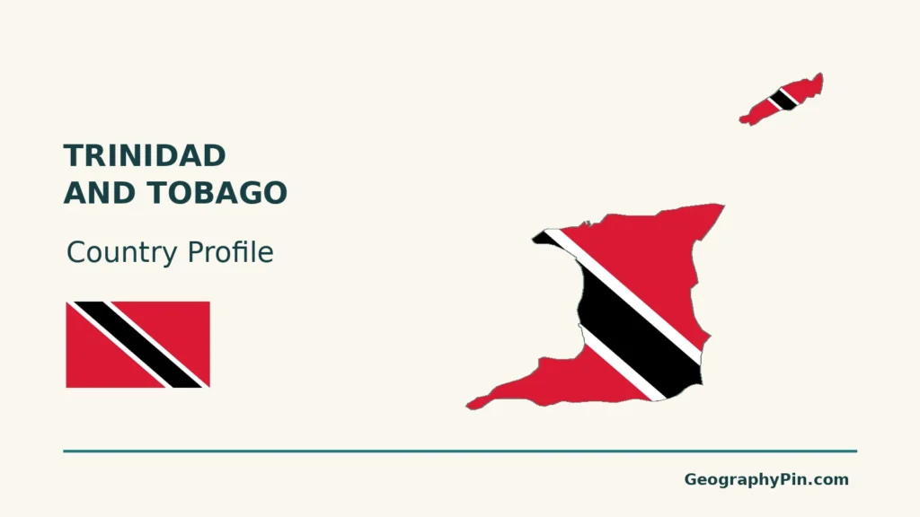
Trinidad and Tobago sits where the Caribbean island chain approaches South America. Yet the two principal islands are not interchangeable: Trinidad combines mountain ranges, lowland basins, wetlands and industrial coasts, while Tobago has a prominent central ridge and a smaller southwestern lowland. Those contrasts help explain their different water systems and patterns of development.
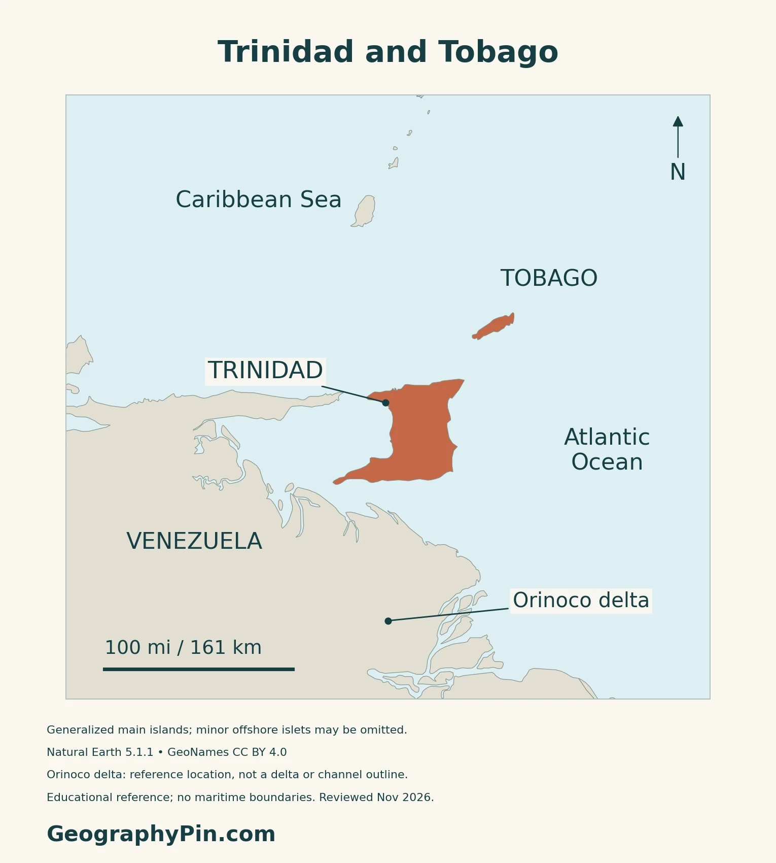
Trinidad and Tobago is one Caribbean republic comprising two principal islands and smaller offshore islands. Trinidad lies close to Venezuela; Tobago is northeast of it. Port of Spain is the national capital, while Scarborough is Tobago’s administrative center. The country’s Caribbean regional identity is distinct from Trinidad’s physical and geological connections with the South American margin.
How to use this article: Clarify the country location, read the physical map, explore water supplies, or check the population reference.
1. Locate the Islands and Define the Country
A Caribbean country close to South America
Trinidad and Tobago is an independent archipelagic country in the southern Caribbean, northeast of Venezuela and south of Grenada. Trinidad and Tobago are its two main islands, accompanied by smaller islands. Trinidad is the larger of the pair; Tobago lies to its northeast.
Port of Spain and Tobago have different roles
Port of Spain, on Trinidad, is the national capital. Scarborough is the location of Tobago’s Assembly Legislature. These are different governmental roles within one country, not the capitals of two sovereign states.
The Caribbean countries and territories map places the islands in their regional context.
2. Mountain Ranges, Basins and the Physical Map
Compare the two principal islands
| Setting | Map reference | Landscape |
|---|---|---|
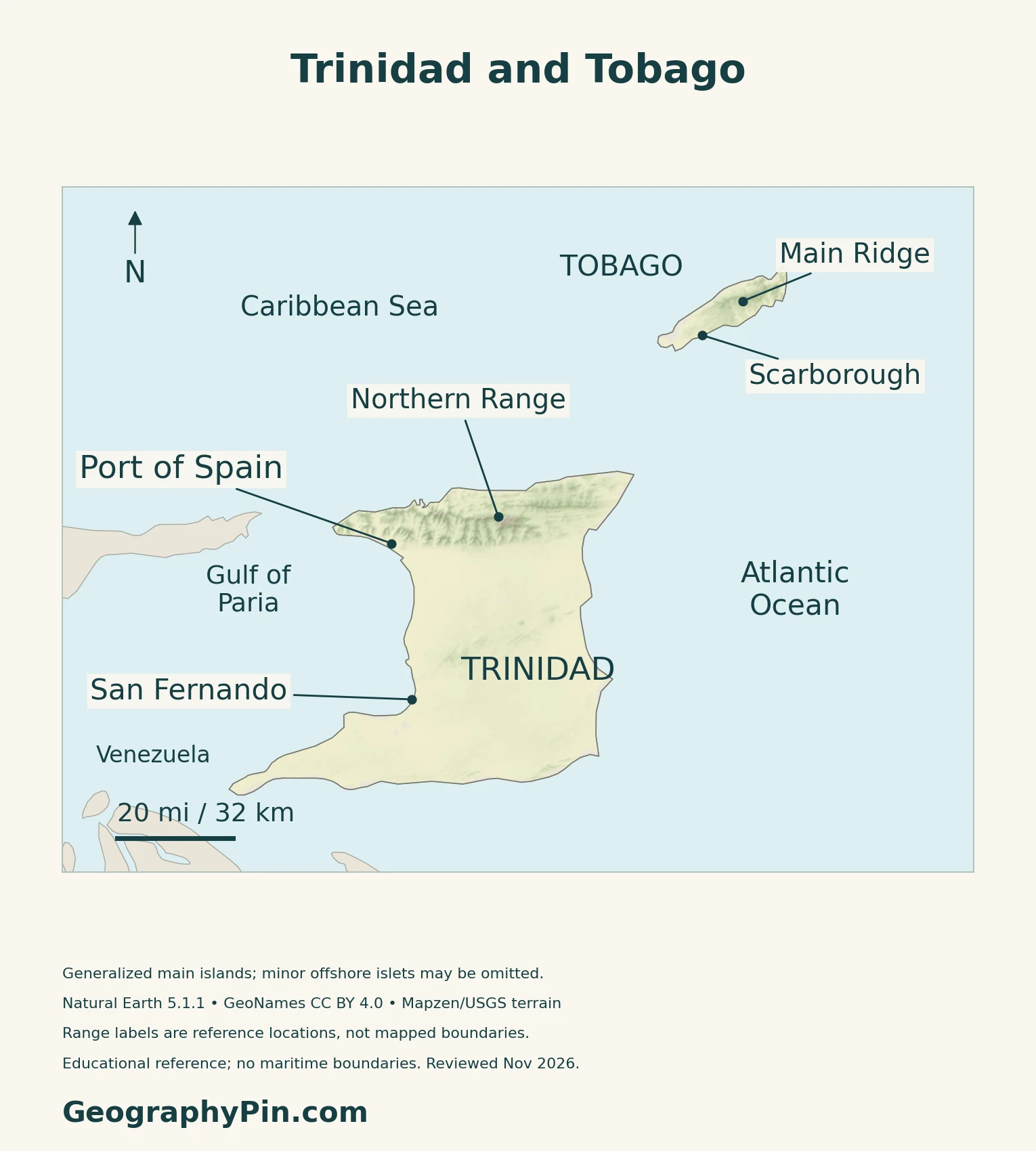
| Northern Trinidad | Northern Range | Mountainous northern belt |
| Central Trinidad | Between the Northern and Central ranges | Lower Caroni Basin |
| Tobago | Main Ridge | Elongated upland spine |
| Southwest Tobago | Southwestern end of the island | Lower coral-limestone platform |
Trinidad has more than one mountain belt
The UWI Seismic Research Centre distinguishes the Northern, Central and Southern ranges, with lower basins between them. The Northern Range contains older metamorphosed rocks related to formations in northern Venezuela; much of the rest of Trinidad is built from sedimentary successions.
Tobago’s Main Ridge contrasts with its southwest
UWI describes Tobago as a mix of metamorphic, igneous and sedimentary rocks. Its Main Ridge is flanked by deep valleys, while the southwestern end has a coral platform.
Regional identity is not a tectonic boundary
Trinidad occupies a complex, actively deforming margin between the Caribbean and South American plates. That geological setting does not determine its political identity or make it part of Venezuela. These maps show geographic reference features, not active-fault traces or earthquake-hazard zones.
3. Seasonal Rainfall and Water Supplies
A wet season and a dry season, not rain versus no rain
The Trinidad and Tobago Meteorological Service describes a dry season generally from January to May and a wet season from June to December, with transitional periods. Showers still occur in the dry season. Terrain, elevation, island size and exposure to the trade winds produce differences between and within the islands.
The service describes Trinidad as wetter than Tobago overall. Daily temperature changes are more pronounced than the seasonal temperature cycle, so rainfall is the clearer seasonal distinction.
Southern location does not eliminate storm effects
Trinidad lies on the southern periphery of the North Atlantic hurricane basin and is directly affected less often than Tobago, according to the national meteorological service. Both islands can still receive peripheral weather from passing tropical systems. The separate Caribbean hurricane-risk guide explains the wider regional pattern.
Reservoirs, groundwater and desalination play different roles
A 2022 water-sector assessment published by the Ministry of Public Utilities describes a national supply mix of surface water, groundwater and desalination. It identifies Arena, Hollis and Navet among Trinidad’s important reservoirs, and Hillsborough in Tobago.
Several Tobago rivers begin in the Main Ridge. The southwest’s permeable limestone allows more infiltration and less surface drainage than the ridge country. Catchment condition and geology therefore matter alongside rainfall. The assessment is a dated structural reference, not a statement of today’s reservoir levels or uninterrupted household supply.
4. Wetlands, Forests and Industrial Coasts
Caroni and Nariva are different wetland systems
Caroni Swamp occupies Trinidad’s west coast beside the Gulf of Paria. Its Ramsar information sheet describes mangroves, marshes, tidal mudflats and brackish or saline lagoons. River inflows and tidal exchange connect the wetland with both inland catchments and coastal waters.
Nariva, on the east coast, is predominantly freshwater but includes several habitats: swamp forest, palm swamp, marshes, open water and mangrove areas. Treating all coastal wetlands as interchangeable would miss that contrast.
Main Ridge belongs to a broader land-and-sea reserve
UNESCO’s North-East Tobago Biosphere Reserve encompasses terrestrial and marine environments and includes the Main Ridge Forest Reserve, protected since 1776. Its designation dates to 2020. This is a biosphere-reserve designation, not the same as inscription on the World Heritage List.
The reserve connects forest conservation with fishing, tourism and village livelihoods.
Point Lisas and Point Fortin have distinct industrial roles
National Energy describes industrial estates and ports arranged around deep-water harbors. Point Lisas serves gas-based petrochemical industries, including the movement of products such as ammonia and methanol. Galeota, on Trinidad’s southeastern peninsula, supports offshore exploration and production activity.
At Point Fortin on the southwest coast, Atlantic processes natural gas into liquefied natural gas, or LNG, for shipment by tanker. These facilities explain why Trinidad’s coast is not only a recreational landscape: offshore resources, processing sites and specialized terminals are closely connected.
5. Country Facts, Population and Institutions
| Item | Reference | Date or scope |
|---|---|---|
| Capital | Port of Spain | National capital, on Trinidad |
| Population | 1,367,764 | Provisional national mid-year estimate, 30 June 2025 |
| Surface area | About 1,980 sq mi (5,127 km²) | UN reference, 2023; not maritime jurisdiction |
| Official language | English | Identified in the OECD’s 2025 country overview |
| Currency | Trinidad and Tobago dollar (TTD) | Distinct national currency |
| Government | Republic | President as head of state; prime minister and Cabinet |
| Island administration | Municipal corporations in Trinidad; Tobago House of Assembly | Different arrangements within one state |
A population estimate, not a new census
The Central Statistical Office gives 1,367,764 people at 30 June 2025. The Ministry of Finance identifies this series as provisional and based on the 2011 census. It covers usual residents, including resident non-nationals, rather than citizens alone.
The underlying population framework includes people in households, institutions and workers’ camps, street dwellers and Trinidad and Tobago students abroad. The figure should not be relabeled as a 2025 census count or a 2026 population total.
National government and Tobago’s Assembly
Trinidad and Tobago has been a republic since 1976. Its president is head of state, and national institutions include the prime minister, Cabinet, House of Representatives and Senate.
The Tobago House of Assembly manages defined island affairs, including planning, public works and aspects of environmental management. It operates within the national constitutional framework. Foreign affairs and national security remain outside its assigned responsibilities, so Tobago’s separate administration does not amount to independence.
What Did We Learn Today?
Trinidad and Tobago is one Caribbean country, not two sovereign states. Trinidad’s ranges, basins and industrial coasts contrast with Tobago’s ridge and southwestern lowland. Wetlands, catchments and marine environments connect land use with water supply and livelihoods. National population estimates, historical environmental assessments and protected-area designations each need their own dates and scope.
Sources & Data Notes
Population is the provisional national estimate for 30 June 2025, not a new census count. Area follows the UN’s 2023 surface-area reference. The 2022 water-sector assessment describes a historical supply framework, not current reservoir levels or household service. Caroni’s Ramsar sheet is dated May 2005. North-East Tobago is a UNESCO biosphere reserve; this designation is not World Heritage inscription. Industrial locations do not establish current plant utilization.
- Central Statistical Office: population estimates and census scope
- Ministry of Finance: 2025 Review of the Economy, population notes
- UNData: dated surface-area and currency reference
- Foreign Ministry: island-country location and capital
- OECD 2025 review: language and institutional overview
- Office of the President: republican institutions
- Tobago House of Assembly: current functions and legislature
- Tobago House of Assembly Act: assigned and reserved responsibilities
- Local Government Ministry: municipal framework
- UWI Seismic Research Centre: Trinidad geology
- UWI Seismic Research Centre: Tobago landforms
- Meteorological Service: seasons and island contrasts
- Ministry of Public Utilities: October 2022 water-sector assessment
- Ramsar: Caroni Swamp information sheet, May 2005
- National biodiversity portal: Nariva Swamp
- UNESCO: North-East Tobago Biosphere Reserve
- National Energy: industrial ports and piers
- Atlantic: Point Fortin LNG processing
Map method: Original GeographyPin maps use Natural Earth 1:10m countries version 5.1.1, public domain. Both supplied island polygons are retained; minor offshore islands are omitted at this scale. Place, range and delta reference locations use GeoNames under CC BY 4.0. No range, delta, maritime or tectonic boundary is inferred. Relief uses actual Mapzen Terrain Tiles with Mapzen/USGS and upstream attribution. Negative samples and a small buffer are omitted to suppress coastal artifacts, not replaced with invented heights. Raster values are not summit measurements. WGS84 geodesic scales apply at the displayed latitude. November 2026 is the review date, not a terrain or coastline survey date. The cover uses the Commons flag rendition, marked public domain as simple geometry, clipped to the two islands with a separate complete flag for editorial identification.