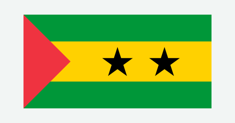
São Tomé and Príncipe is a small island country with substantial differences over short distances. Mountainous interiors, wetter forested slopes, cultivated land and coastal settlements all fit within its two main islands. Reading the relief alongside the island names helps explain both the landscape and why a national map needs to show more than São Tomé alone.
São Tomé and Príncipe is an African island country in the Gulf of Guinea. Its two main islands are volcanic, and São Tomé city is the national capital. The equator crosses the small Ilhéu das Rolas, south of São Tomé island. Mountainous terrain creates strong rainfall contrasts, while Príncipe combines a gentler north with a rugged southern interior.
How to use this article: Locate the country on the map, read the physical map, explore rainfall contrasts, or check the population reference.
1. Locate the Islands and the National Capital
Two main islands in the Gulf of Guinea
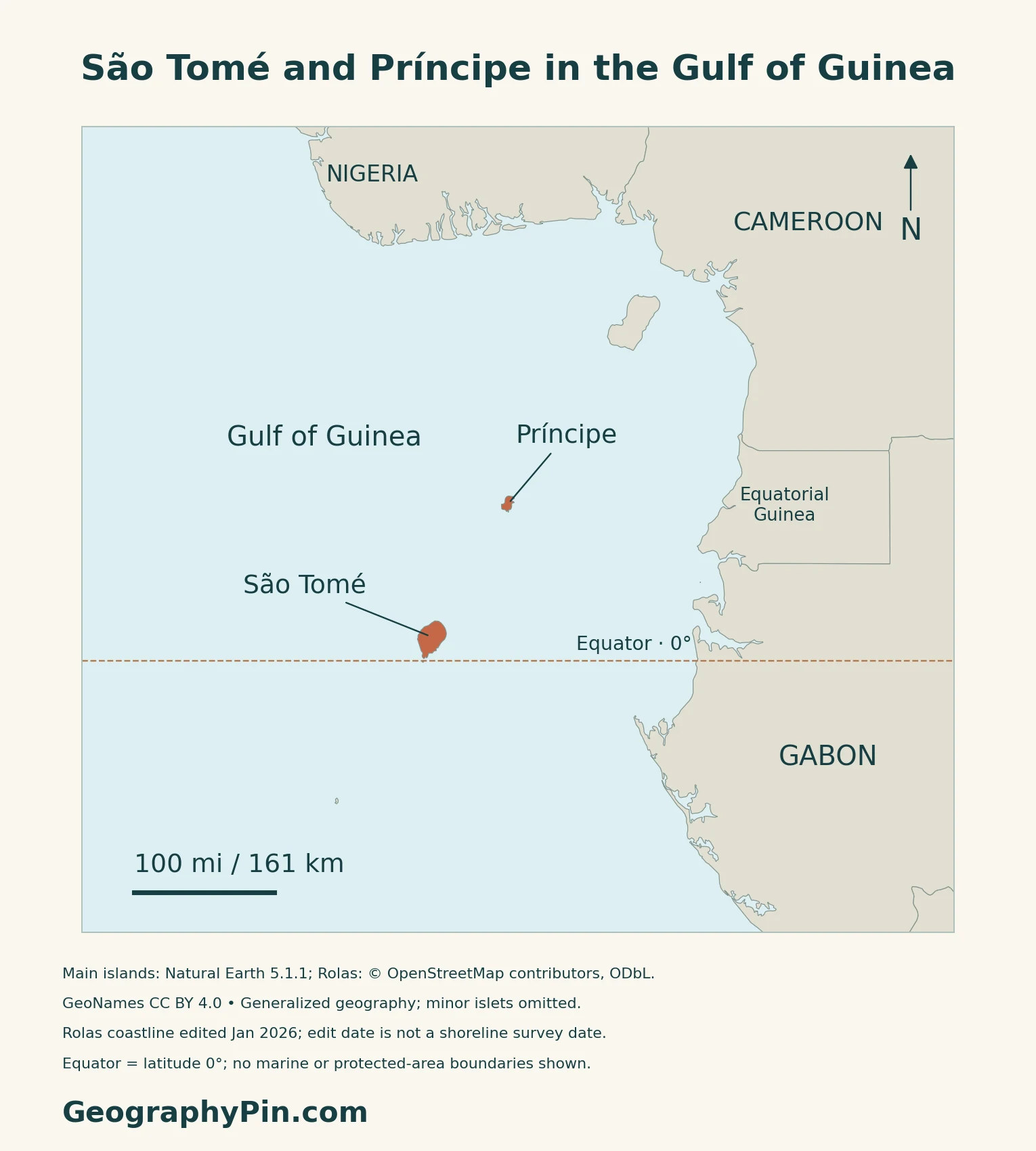
São Tomé and Príncipe is an island state in the Gulf of Guinea, off Africa’s Atlantic coast and grouped with Central Africa. The national territory includes the two main islands and smaller islets. São Tomé is the larger main island; Príncipe lies to its northeast. The country has no land border with mainland Africa.
São Tomé is both an island name and a city name
The city of São Tomé, on São Tomé island, is the national capital. Article 5 of the Constitution names the city explicitly. The island, the capital city and the country are therefore three different geographic units, even though they share part of their name.
Where does the equator cross the country?
Ilhéu das Rolas lies off São Tomé’s southern tip and straddles latitude 0°. Both main islands lie north of the equator. The country therefore belongs on a map of countries crossed by the equator, even though the line does not cross its largest island.
2. Compare the Two Volcanic Islands
The larger island is not the whole country
| Place | Landscape | How to read it |
|---|---|---|
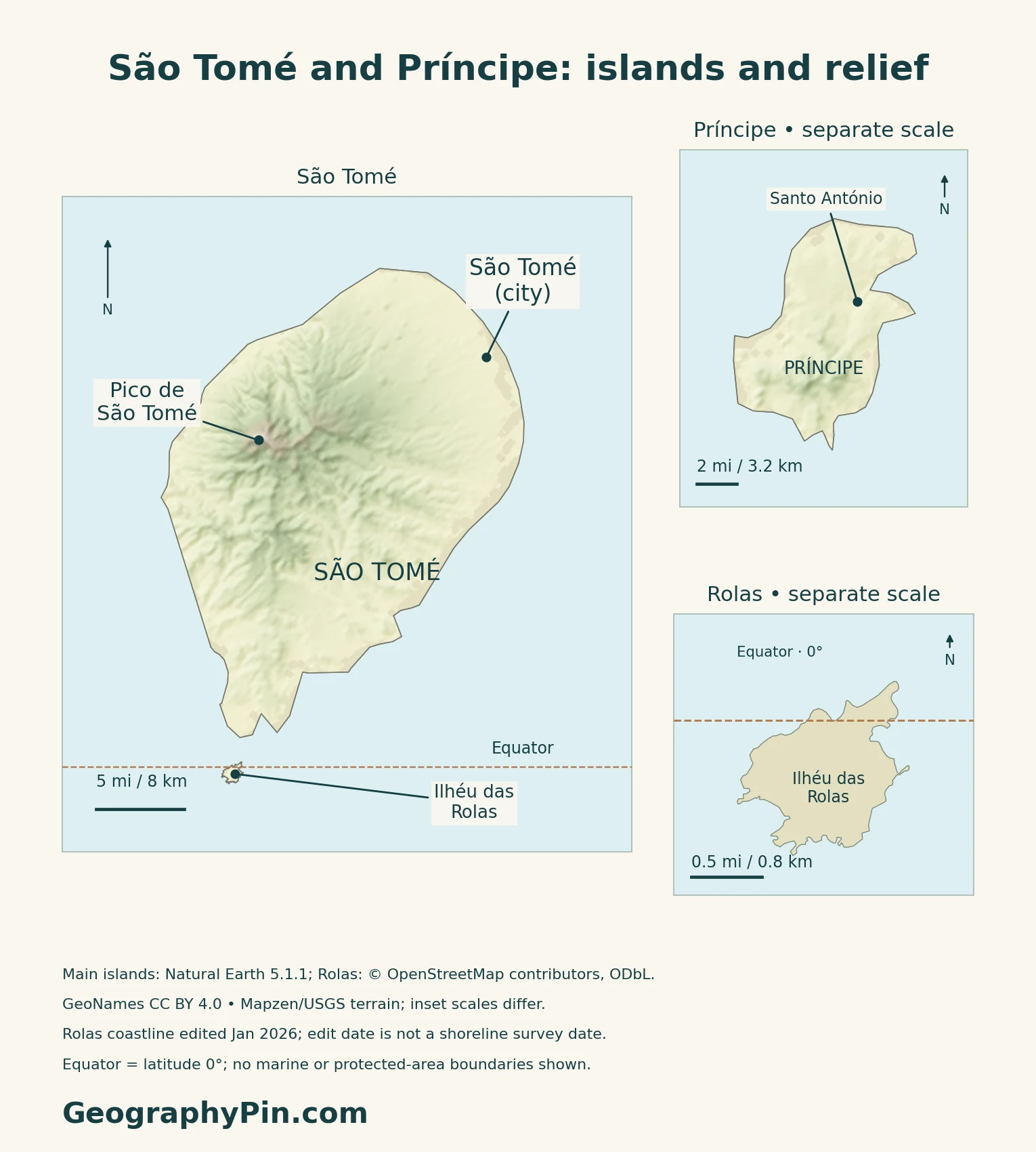
| São Tomé interior | High ridges, steep slopes and deep valleys | Relief divides wetter and drier settings |
| São Tomé coastal areas | Lower ground, settlements and cultivated landscapes | Not every green area is native forest |
| Príncipe | Gentler northern terrain and southern volcanic peaks | A separate island with its own internal contrasts |
| Ilhéu das Rolas | Small island beside the equator | Distinct from the main island of São Tomé |
São Tomé rises sharply above the Atlantic
Pico de São Tomé reaches about 6,640 ft (2,024 m). A 2022 scientific synthesis describes a ridge extending southward through the island, with a generally wetter western side and drier eastern side. Gentler ground occurs in the northeast and parts of the southern coast.
Príncipe has a different north–south contrast
UNESCO describes Príncipe’s northern half as comparatively gentle, while its southern half contains a mountain range with distinctive volcanic peaks and primary rainforest. The relief changes local climates and habitats across an island that can look very small on a continental locator map.
3. Rainfall, Rivers and Water Supply
Equatorial location does not mean uniform rainfall
São Tomé’s higher terrain intercepts moist air, producing strong rainfall contrasts. The western and southwestern mountain areas are much wetter than the northern and northeastern lowlands.
The longer relatively dry season, gravana, falls around the middle of the year. A shorter dry interruption is called gravanito. Timing varies by location and source.
Short island drainage links mountains with communities
The national biodiversity portal describes rivers rising in São Tomé’s central massif and descending through valleys toward the coast. Forests, rainfall and steep relief together shape these water resources, which support domestic supply, irrigation and hydropower.
A wet climate does not guarantee reliable treated water. UNDP’s flood-and-water-security project identifies intense runoff, sediment entering water systems and inadequate urban drainage as connected problems in São Tomé and Santo António. Heavy rain can interrupt treatment just when water is most abundant in the rivers.
The project therefore links upstream catchment management with drainage, waste management and water-quality monitoring.
4. Forests, Working Landscapes and Coastal Connections
Biosphere reserves include inhabited landscapes
Príncipe entered UNESCO’s biosphere-reserve network in 2012, and Ilha de São Tomé followed in 2025. These designations are not World Heritage inscriptions. São Tomé’s reserve combines the Obô Natural Park core with surrounding agricultural, community, coastal and marine areas.
The Obô park is itself a varied landscape. The national biodiversity portal distinguishes the central forested massif, northern savannas and southern Malanza mangrove. A biosphere reserve, a national park and an island coastline are different kinds of boundary.
Cocoa landscapes are not all untouched forest
UNESCO’s São Tomé profile connects local livelihoods with fishing, cocoa and coffee cultivation, coconut processing and the historic plantation estates known as roças. Príncipe’s reserve profile also describes agriculture and fishing alongside tourism.
Native forest and tree-covered agriculture can look similar from a distance. The national biodiversity portal separates native forest, regrowth after earlier disturbance and shade plantations.
Coastal roads connect livelihoods and services
A May 2026 World Bank project account identifies the EN1 and Lagarto Bay roads as important links between settlements, markets, schools, fishing areas and tourism. Flooding and coastal erosion can therefore disrupt much more than a journey along the shore.
The account describes a transport-resilience project combining road rehabilitation with vegetation, slope stabilization and runoff management. This connects the upland landscape with coastal infrastructure: the effects of water do not stop at a catchment’s lower edge.
Energy is another constraint. The World Bank’s August 2025 economic update linked unreliable, expensive diesel-based electricity with wider economic difficulties. Tourism and agricultural activity depend on those services as well as on the islands’ natural attractions.
5. Dated Country Facts and Island Administration
| Item | Reference | Date or scope |
|---|---|---|
| Capital | São Tomé | City on São Tomé island; Constitution, Article 5 |
| Population | 209,607 residents | 2024 census; July 2025 report retains provisional wording |
| Surface area | About 372 sq mi (964 km²) | UN reference, 2023; not presented as land-only |
| Official language | Portuguese | CPLP country reference; local languages are also spoken |
| Currency | Dobra (STN) | 100 cêntimos; current currency code introduced in 2018 |
| Government | Unitary republic | President as head of state; prime minister as head of government |
| Administration | Six districts on São Tomé and the Autonomous Region of Príncipe | Príncipe has its own regional assembly and government |
What the 2024 census total counts
The census reference was the night of November 14–15, 2024. Its resident total combines residents present and temporarily absent, excluding visitors. INE’s July 2025 report still describes its results as provisional; the figure is not a 2026 population estimate.
The same census places 95.3% of residents on São Tomé and 4.7% on Príncipe. That island comparison is not a capital-city population count.
A national republic with regional autonomy
Portuguese is the official language. Forro, Angolar and Lunguye are among the local languages identified by Portugal’s Camões institute; official-language status does not make the population linguistically uniform.
The Constitution separates the president’s role as head of state from the prime minister’s leadership of government. Article 137 gives Príncipe and its surrounding islets autonomous regional status, with a regional assembly and regional government, within the same republic.
The area table follows the UN’s dated surface-area series. National information pages also use about 386 sq mi (1,001 km²); the difference is not identified here as inland water or territorial sea.
What Did We Learn Today?
São Tomé and Príncipe is one country, but its two main islands have different terrain and administrative roles. The equator crosses Ilhéu das Rolas rather than either main island. Volcanic relief, uneven rainfall and short drainage routes help connect upland forests with agriculture, towns and coastal infrastructure. A useful map keeps these island-scale contrasts visible.
Sources & Data Notes
Census figures retain their original reference date and coverage. Biosphere reserves are distinct from World Heritage properties and national parks. The 2022 ecosystem synthesis warns that detailed rainfall patterns still depend on older observations; no new rainfall survey or forecast is presented here. UNDP project descriptions identify intended interventions, not completed results. The World Bank accounts refer to their stated 2025 and 2026 publication contexts.
- INE: 2024 census results report, July 2025; reference night and resident coverage
- UNData: 2023 surface area
- National Assembly: Constitution, capital, government and Príncipe autonomy
- CPLP: Portuguese official-language status
- Camões institute: six São Tomé districts, Príncipe and local languages
- Central Bank: dobra and 100-cêntimo subdivision
- Central Bank notice: STN currency code from January 2018
- Government of São Tomé and Príncipe: island geography and alternative national area convention
- Dauby and colleagues (2022): Classification, Distribution, and Biodiversity of Terrestrial Ecosystems in the Gulf of Guinea Oceanic Islands
- UNESCO: Ilha de São Tomé Biosphere Reserve (2025 designation)
- UNESCO: Island of Príncipe Biosphere Reserve (2012 designation)
- National biodiversity clearing-house: Obô Natural Park of São Tomé, May 2026
- UNDP: Flood resilience and water-security project description
- World Bank: Coastal roads and nature-based resilience, May 2026
- World Bank: São Tomé and Príncipe Economic Update, August 2025
- National tourism portal: Rolas Islet and its equator location
Map method: Original GeographyPin maps use public-domain Natural Earth countries 5.1.1 for the two main islands. Rolas uses actual OpenStreetMap coastline geometry, credited to © OpenStreetMap contributors under ODbL, including in the cover. The January 2026 edit date is not a shoreline survey date. Other minor islets are omitted. The equator is latitude zero; its intersection with the supplied Rolas polygon was checked rather than drawn by eye. GeoNames location data are credited under CC BY 4.0. Main-island relief uses real Mapzen Terrain Tiles with Mapzen/USGS and upstream credits; coastal raster artifacts are transparent, not replaced with invented heights. Rolas’s separate-scale detail has no elevation shading. WGS84 scales apply at each panel’s displayed latitude. No marine or protected-area boundaries are shown. The cover uses the public-domain Commons flag rendition, with a separate complete flag for editorial identification.