Saint Vincent and the Grenadines combines a mountainous main island with a chain of smaller islands extending south. That arrangement creates contrasting water supplies, transport needs and exposure to disruption. The country is best understood as an interconnected archipelago, not as Saint Vincent alone or as the whole Grenadines island chain.
Saint Vincent and the Grenadines is an independent eastern Caribbean country comprising Saint Vincent and the northern part of the Grenadines. Kingstown is its capital. Saint Vincent has volcanic mountains, including La Soufrière, while smaller islands such as Bequia and Union Island have distinct settlements, water systems and sea connections. The southern Grenadines also include islands belonging to Grenada.
How to use this article: Clarify the country location, read the physical map, explore water supplies, or check the population reference.
1. Locate the Country and Distinguish the Grenadines
One country within a wider island chain
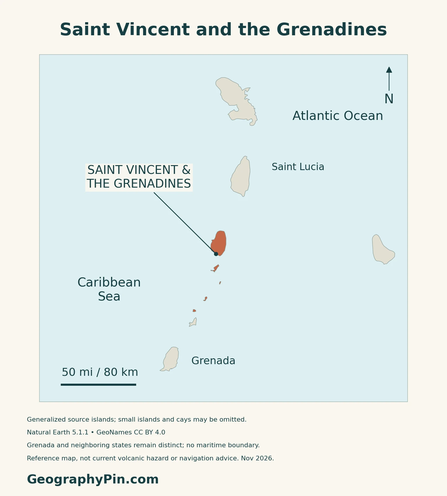
Saint Vincent and the Grenadines lies in the Windward Islands of the eastern Caribbean. Saint Vincent is the main island; the country also includes Bequia, Mustique, Canouan, Mayreau, Union Island, Palm Island, Petit Saint Vincent and smaller islets.
The Grenadines extend beyond this country
The geographic Grenadines chain is shared with Grenada. Carriacou and Petite Martinique belong to Grenada, not to Saint Vincent and the Grenadines. An island-chain label therefore does not by itself identify national territory.
Kingstown, on Saint Vincent, is the national capital. The Caribbean countries and territories map places the country in its regional setting.
2. Saint Vincent, the Island Chain and the Physical Map
Compare the main island with the Grenadines
| Setting | Map reference | Geographic distinction |
|---|---|---|
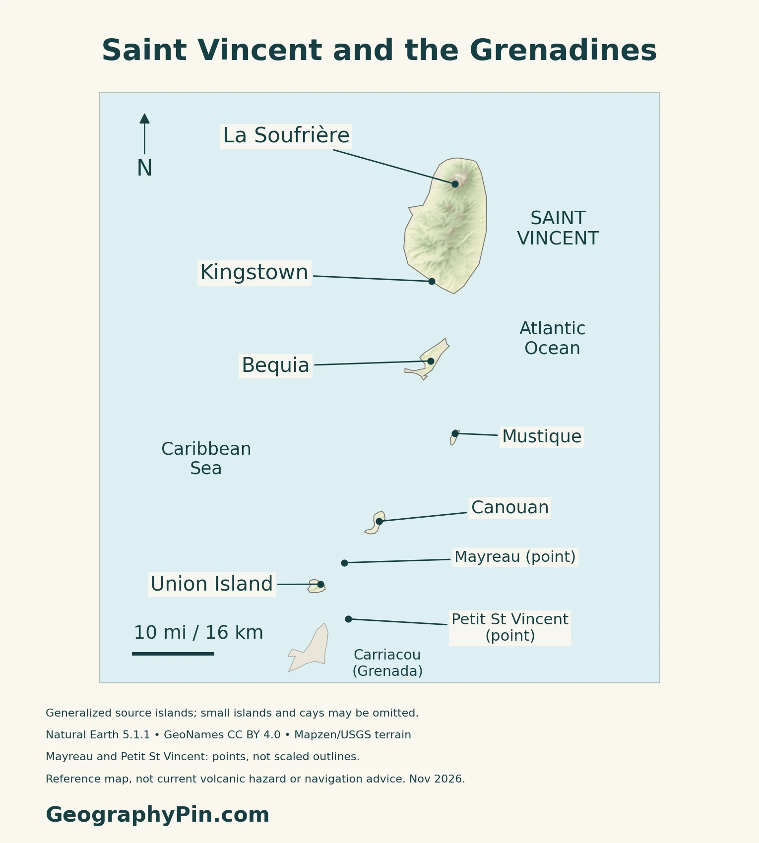
| Saint Vincent | Kingstown and La Soufrière | Large mountainous main island |
| Bequia | South of Saint Vincent | Separate island and port connections |
| Canouan and Union Island | Farther south in the chain | Smaller islands with their own communities |
| Tobago Cays area | Near Mayreau | Small cays and marine habitats, not mainland terrain |
A mountainous spine shapes Saint Vincent
The UWI Seismic Research Centre describes a north–south chain of volcanic mountains. La Soufrière stands in the north, while older volcanic centers form much of the interior. Erosion has cut deeply into these older landscapes.
The 2020–2021 eruption is a dated event
According to UWI’s eruption fact sheet, lava extrusion began in December 2020 and the first explosive eruption followed on April 9, 2021. The last recorded explosion in that episode occurred on April 22. Heavy rainfall subsequently generated mudflows in affected communities.
These dates describe an eruption episode, not a current alert level. The map locates La Soufrière but does not show evacuation zones or establish whether a particular trail is open.
Grenadines does not mean one sovereign jurisdiction
Union Island is toward the southern end of this country, even though the country occupies the northern part of the wider Grenadines chain. Descriptions of the “Southern Grenadines” in national reports can refer to the country’s own southern islands, not automatically to the separate state of Grenada.
3. Rainfall, Catchments and Island Water Supplies
The mountain island is wetter than the smaller islands
The Caribbean Institute for Meteorology and Hydrology describes a tropical marine climate, with wetter conditions generally from June to November. Rainfall is substantially lower in the Grenadines than in the high terrain of Saint Vincent, where rising air over the mountains contributes to wetter conditions.
Its historical profile reports an annual average of about 84 inches (2,145 mm) at E. T. Joshua Airport for 1979–2015. That is a station record, not a national average or a measurement for every Grenadine island. Temperature varies less through the year than rainfall does.
Catchments, tanks and sea deliveries serve different places
The Central Water and Sewerage Authority describes a mainland network supplied from multiple catchments, including the Dalaway and Jennings systems.
The August 2021 post-disaster sector assessment describes Grenadine water sources including rooftop tanks, public rainwater catchments, seasonal ponds and wells, desalination and transfers by sea. Their mix differs from the river-fed systems of Saint Vincent. Storage and dependable delivery matter alongside the amount of rain.
This is a dated baseline, not an inventory of every plant operating today. A January 2026 World Bank recovery update reported water shipments after Hurricane Beryl and plans for additional desalination capacity. Planned plants should not be read as already commissioned.
4. Marine Habitats, Transport and Recovery
Tobago Cays connects islands with surrounding waters
The Tobago Cays Marine Park’s description includes five uninhabited cays, Mayreau and surrounding marine environments. Coral reefs, seagrass beds and small mangrove systems support different habitats within the same island setting.
Horseshoe Reef encloses four of the principal cays, while Petit Tabac lies outside it to the east. These relationships explain why a map of land outlines alone cannot represent the whole protected marine landscape. The reference map does not attempt to draw reef navigation channels or the park’s regulatory zones.
Kingstown links the main island to smaller ports
The national port operator identifies facilities at Kingstown and Port Elizabeth on Bequia, alongside other cargo and specialized berths on Saint Vincent. Its marine responsibilities extend across the island group toward Union Island.
For an archipelago, the movement of passengers, supplies and materials across water is part of domestic connectivity, not just international trade.
Hurricane Beryl affected the islands unevenly
Hurricane Beryl struck the country in July 2024. The World Bank’s January 2026 recovery account identifies Union Island among the hardest-hit places and describes damage to housing, electricity, water and transport infrastructure in the country’s southern Grenadines.
The same account reports livelihood support and reconstruction activity. The separate Caribbean hurricane-risk guide provides the broader regional context.
Construction and energy costs connect geography with the economy
The IMF’s June 2026 consultation emphasized the effects of repeated external shocks, reconstruction-related activity and exposure to imported energy costs. Its recommendations included strengthening resilience and advancing the energy transition.
Those concerns connect the country’s scattered settlements with the cost of maintaining ports, utilities and public services.
5. Country Facts, Census Coverage and Institutions
| Item | Reference | Date or scope |
|---|---|---|
| Capital | Kingstown | On the main island of Saint Vincent |
| Population | 109,296 | 2023 census total population; 15 June 2023 |
| Surface area | About 150 sq mi (389 km²) | UN reference, 2023; not maritime jurisdiction |
| Language | English | Official language identified by the national government |
| Currency | East Caribbean dollar (XCD) | National currency |
| Government | Parliamentary constitutional monarchy | Sovereign represented by a governor-general |
| Territorial divisions | Six parishes | Not the same as the census divisions |
Total population is not household population
The Statistical Office’s 2023 census report records a total population of 109,296. This includes 108,764 people in households, together with institutional residents and people without a fixed abode. Many detailed tables cover only the household population, so their totals should not replace the national figure.
The report defines its total as the de jure population, including usual residents temporarily abroad under its coverage rules. It is a census reference for 15 June 2023, not a current headcount or a 2026 projection.
Language and national institutions
The government identifies English as the official language.
The sovereign is represented by a governor-general, while the prime minister and Cabinet exercise executive authority. The country has a single parliamentary chamber, the House of Assembly. Its six parishes should not be confused with separately elected regional governments or with statistical census divisions.
What Did We Learn Today?
Saint Vincent and the Grenadines is one country spanning a mountainous main island and smaller islands to its south, but it does not include the whole Grenadines chain. Kingstown anchors the national network; rainfall, water sources and transport connections differ across the islands. Eruption history and hurricane recovery are important context, but their dates should not be mistaken for current alerts or completed projects.
Sources & Data Notes
Population follows the national 2023 census report’s total, including institutional residents and people without a fixed abode, rather than its household-only tables. Area follows the UN’s 2023 surface-area reference. Rainfall statistics use the E. T. Joshua station’s 1979–2015 record and are not national means. The August 2021 water-sector assessment is a historical baseline, supplemented by a January 2026 recovery account. Eruption dates concern 2020–2021, not a live alert. UNESCO’s Grenadines entry is a tentative submission, not an inscribed World Heritage property.
- Statistical Office: 2023 Population and Housing Census report
- UNData: dated area, capital and currency reference
- Government: country geography and official language
- Grenada National Commission: Grenadines island-group submission, 2013
- WTO: national government and parish framework, 2023 review
- UWI Seismic Research Centre: island geology
- UWI: 2020–2021 eruption fact sheet
- Caribbean Institute for Meteorology and Hydrology: historical climate profile
- Central Water and Sewerage Authority: mainland catchment systems
- August 2021 eruption sector assessment: water and sanitation
- World Bank: January 2026 Beryl recovery account
- Tobago Cays Marine Park: habitats and island setting
- National port operator: Kingstown and island port facilities
- Government BERRy project: hurricane date and recovery scope
- IMF: June 2026 consultation
Map method: Original GeographyPin maps use Natural Earth 1:10m countries version 5.1.1, public domain. All five source islands are retained: Saint Vincent, Bequia, Mustique, Canouan and Union Island. Mayreau and Petit Saint Vincent use GeoNames location points under CC BY 4.0, not scaled outlines; Palm Island, Tobago Cays and other small islands may be absent. Grenada remains distinct, without maritime boundaries. Actual Mapzen Terrain Tiles supply qualitative relief with Mapzen/USGS and upstream attribution. Negative coastal samples and a small buffer are omitted, not replaced with invented heights. The terrain is not a current crater survey or hazard map. WGS84 geodesic scales apply at their displayed latitudes. November 2026 is the review date, not a coastline or terrain survey date. The cover shows the same five source islands, not every island in the state, with a separate intact flag for editorial identification. The Commons flag rendition is marked public domain as simple geometry.