Saint Lucia’s famous Pitons are one part of a larger mountainous island. Its capital and ports, forested interior, Atlantic-facing coast and southern airport occupy different settings. Reading those places together explains how relief, water catchments and transport connections shape life beyond the familiar southwestern landmark.
Saint Lucia is an independent island country in the eastern Caribbean’s Lesser Antilles, with Castries as its capital. Its landscape combines a mountainous interior, the Pitons near Soufrière and contrasting Atlantic and Caribbean coasts. Rainfall, catchment conditions and coastal transport hubs help explain where communities, tourism and essential infrastructure are concentrated.
How to use this article: Clarify the country location, read the physical map, explore water supplies, or check the population reference.
1. Locate Saint Lucia and Its Coastal Centers
Saint Lucia in the Windward Islands
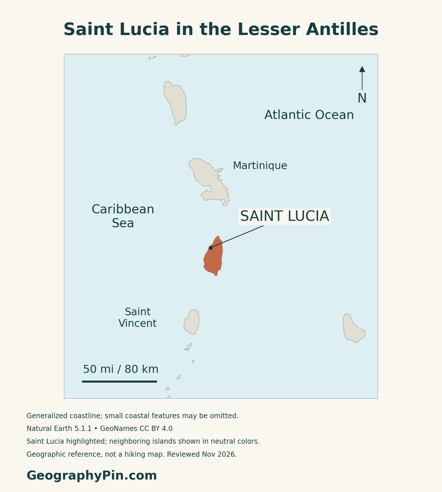
Saint Lucia is an independent island country in the Windward Islands of the Lesser Antilles. It lies south of Martinique and north of Saint Vincent, with Barbados farther to the southeast. The Atlantic Ocean borders its eastern coast and the Caribbean Sea its western coast.
Castries is both a city name and a district name
Castries, on the northwest coast, is the national capital. Its name also appears in census tables as a district, covering a wider area than the city itself. District population figures should therefore not be presented as the capital city’s population.
The Caribbean countries and territories map shows Saint Lucia’s position among neighboring islands.
2. Volcanic Relief, the Pitons and the Physical Map
Read the island from interior to coast
| Setting | Map reference | Why it matters |
|---|---|---|
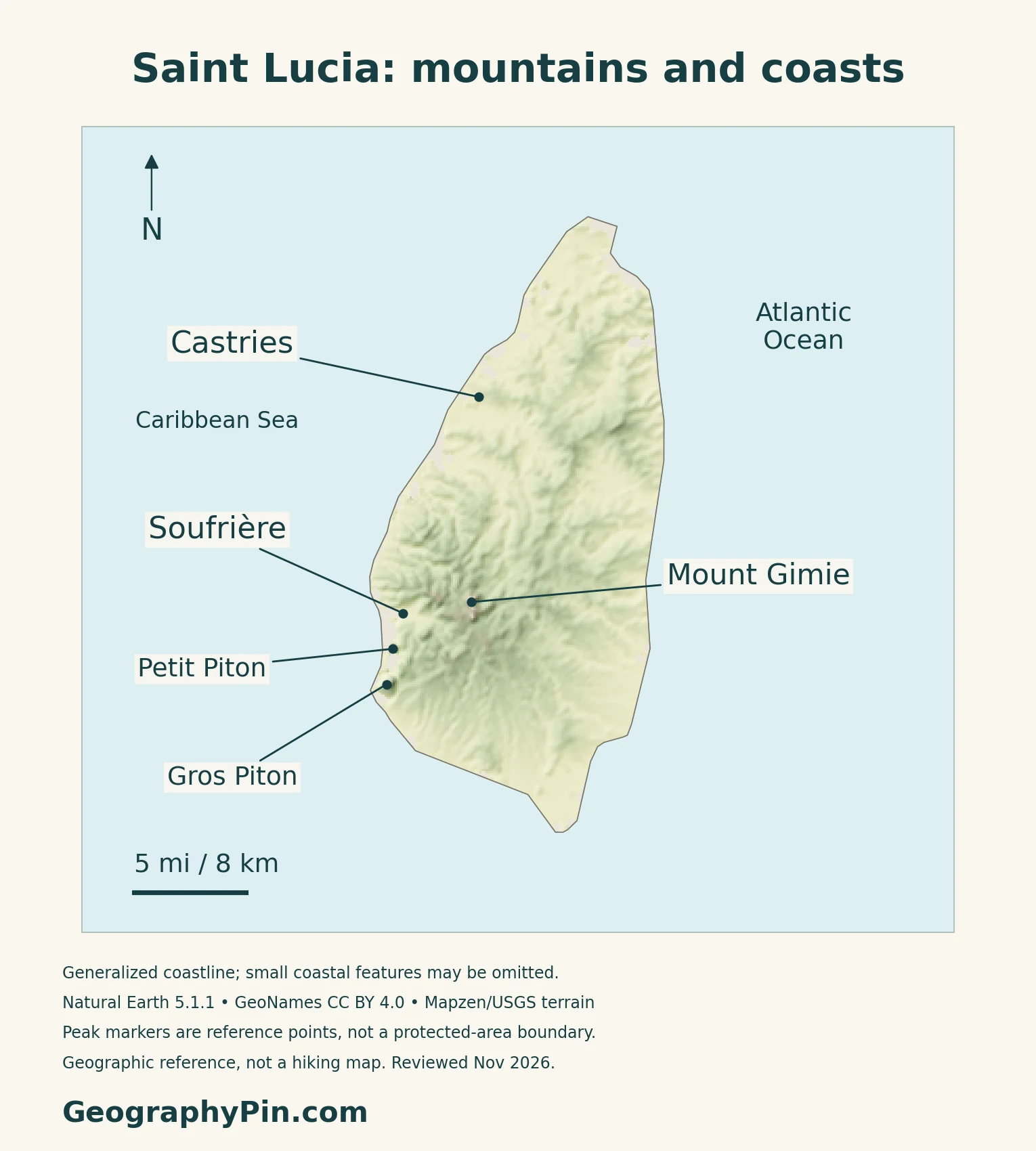
| Interior highlands | Mount Gimie and surrounding mountains | Forested relief separates coastal communities |
| Southwest | Soufrière, Gros Piton and Petit Piton | Distinctive volcanic landforms and protected landscapes |
| Eastern shore | Atlantic coast | A more exposed coastal setting |
| Northwest and south | Castries and Vieux Fort | Separate port and airport connections |
The Pitons are remnants of lava domes
The UWI Seismic Research Centre identifies Gros Piton and Petit Piton as remnants of old lava domes. Erosion removed much of their surrounding material, exposing the steep forms visible today. They are not the rims of two matching open craters.
The wider Soufrière Volcanic Centre includes domes, lava flows, explosive deposits and the Sulphur Springs geothermal area. Mount Gimie belongs to the central mountain landscape, rather than to the pair of coastal Pitons. The map marks these features as locations, not as surveyed geological boundaries.
A World Heritage landscape extends beyond two peaks
UNESCO inscribed the Pitons Management Area in 2004. The property includes terrestrial and marine environments, with forested slopes, coastal habitats, reefs and geothermal features. Protecting it therefore involves more than preserving the outline of the two peaks.
In its 2025 review, the World Heritage Committee welcomed legally binding development controls but also requested clarification of discrepancies between boundary maps and stated property sizes. The country map here does not draw a purportedly definitive World Heritage boundary.
3. Rainfall, Catchments and Water Supply
Seasonal averages are station-specific
Saint Lucia Meteorological Services describes a drier season from December to May and a wetter season from June to November. Its published climatology presents Hewanorra in the south and George F. L. Charles at Castries separately, rather than treating the island as one rainfall station.
At Hewanorra, the listed monthly averages range from about 2–4 inches (50–99 mm) in the drier season to about 5–8 inches (136–191 mm) in the wetter season. These are ranges among monthly averages at one station, not totals for the entire season or predictions for a particular month. The page does not state a climatological baseline period.
Mountain catchments connect land use with water security
The national Water Sector Adaptation Strategy and Action Plan 2018–2028 emphasizes reliance on surface-water sources. It connects erosion and landslides with sediment entering rivers and reservoirs, reducing storage and affecting water quality. Protecting a catchment is therefore also part of protecting the supply available downstream.
The John Compton Dam, built along the Roseau River near Millet in the 1990s, provides a concrete example. A 2016 government rehabilitation notice identified sedimentation as a constraint on reservoir storage. A May 2021 update reported completion of an initial desilting phase, not removal of the entire sediment problem.
In January 2026, the agriculture ministry again emphasized storage, distribution and water conservation during the dry season. A wet tropical setting does not remove the need to manage seasonal shortages and infrastructure limits.
4. Coastal Connections, Habitats and Economic Geography
Atlantic frontage and northern tourism centers
The tourism authority describes the eastern shore as Atlantic-facing and more exposed to powerful waves. Its regional overview contrasts that coast with the central rainforest landscape and the northern concentration of resorts, marinas and services around Gros Islet and Rodney Bay.
Castries and Vieux Fort are different gateways
The Saint Lucia Air and Sea Ports Authority identifies Castries and Vieux Fort as the two principal seaports. It also operates George F. L. Charles Airport and Hewanorra International Airport. Hewanorra is near Vieux Fort in the south, not in the capital.
This arrangement gives the country more than one major entry point. Port facilities, air connections and the roads between them link coastal settlements with tourism and trade.
Forests, wetlands and reefs support different activities
Saint Lucia’s Convention on Biological Diversity profile describes habitats ranging from dry scrub to rainforest, mangroves and coral reefs. It also identifies the Saint Lucia parrot as an endemic species. The country’s environmental geography is consequently broader than its beaches and celebrated mountain views.
That profile connects tourism and agriculture with natural resources while recognizing that land conversion and pollution can damage the same systems.
Tourism links local landscapes with external demand
The IMF’s January 2026 review highlighted tourism and construction in recent economic performance and identified external demand, import costs and natural disasters as risks. This helps explain why coastal infrastructure and visitor connections matter to the broader economy, beyond the boundaries of individual resort areas.
The separate Caribbean hurricane-risk guide provides regional context. Neither seasonal climatology nor this physical map is a current storm forecast.
5. Country Facts, Population Scope and Government
| Item | Reference | Date or scope |
|---|---|---|
| Capital | Castries | Northwest coast; distinguish the city from its census district |
| Population | 172,948 | Provisional 2022 census resident population; night of 12/13 March 2022 |
| Surface area | About 238 sq mi (616 km²) | UN reference, 2023; not maritime jurisdiction |
| Languages | English; Kwéyòl widely spoken | English described as official by the Tourism Authority |
| Currency | East Caribbean dollar (XCD) | National currency |
| Government | Parliamentary constitutional monarchy | Governor-general represents the sovereign |
| Census geography | Ten districts | Geography used in the 2022 census report |
A provisional census total with defined coverage
The Central Statistical Office’s provisional 2022 report gives 172,948 usual residents, including people in institutions and excluding temporary visitors. Its household population figures were adjusted for undercount using geographically varying weights informed by mapping and listing work. This is a dated census result, not a 2026 population estimate.
The report remains labeled provisional in the CSO’s publication list. Its ten census districts are statistical areas; civil-registration and electoral units serve different purposes and should not be substituted for them.
Language and institutions
English is the official language identified by the Saint Lucia Tourism Authority, while Kwéyòl, a French-based Creole, is widely spoken.
The governor-general performs constitutional duties on the sovereign’s behalf. National institutions include the prime minister and Cabinet, the House of Assembly and the Senate.
What Did We Learn Today?
Saint Lucia is one independent country with Castries as its capital. The Pitons, interior highlands and Atlantic-facing coast form different geographic settings, while Castries and Vieux Fort provide separate transport connections. Catchment condition, seasonal rainfall and infrastructure help explain water supply; dated population and planning sources should be read with their stated coverage.
Sources & Data Notes
Population follows the national 2022 provisional census report and its stated usual-residence scope. Rainfall figures are ranges of monthly averages at Hewanorra station, not season totals; the meteorological page does not supply baseline years. The water-sector plan covers 2018–2028, and the dam notices describe 2016 and 2021 conditions. UNESCO’s 2025 review identifies unresolved property-boundary discrepancies; no protected-area boundary is drawn here. IMF forecasts are not presented as completed economic outcomes.
- Central Statistical Office: provisional 2022 census report
- CSO: publication list and report status
- UNData: Saint Lucia reference profile
- Saint Lucia Tourism Authority: location and language
- Governor-General: constitutional roles
- Civil Status Act: registration districts
- UWI Seismic Research Centre: Saint Lucia geology
- UNESCO: Pitons Management Area
- UNESCO: 2025 Pitons conservation decision
- Meteorological Services: station climatology
- Water Sector Adaptation Strategy and Action Plan 2018–2028
- Government: John Compton Dam rehabilitation notice, 2016
- Government: initial desilting phase, May 2021
- Agriculture Ministry: January 2026 water conservation notice
- Tourism Authority: regional geography
- SLASPA: seaports and airports
- SLASPA: Hewanorra location
- Convention on Biological Diversity: Saint Lucia habitats
- IMF: January 2026 consultation report
Map method: Original GeographyPin maps use Natural Earth 1:10m countries version 5.1.1, public domain. The complete generalized mainland polygon is retained; minor coastal features and islets may be absent at this scale, and no separate Pigeon Island outline is invented. Place and peak markers use GeoNames under CC BY 4.0. Petit Piton and Gros Piton are shown as two verified locations, not as a protected-property boundary. Relief uses actual Mapzen Terrain Tiles with USGS and upstream attribution. Negative samples and a small buffer are omitted to avoid coastal artifacts, not replaced with invented heights. Raster values are not summit measurements. WGS84 geodesic scales are calculated at their displayed latitude. Review date: November 2026, not a coastline or terrain survey date. The cover combines the geographic outline with an intact national flag for editorial identification; the Wikimedia Commons flag rendition is marked public domain as simple geometry.