Papua New Guinea is not another name for the whole island of New Guinea. Its territory combines the island’s eastern part with offshore archipelagos. A mountain belt, broad river lowlands and widely separated islands create very different settings for farming, towns and transport. The contrast between a highland valley and an island harbor is central to understanding the country.
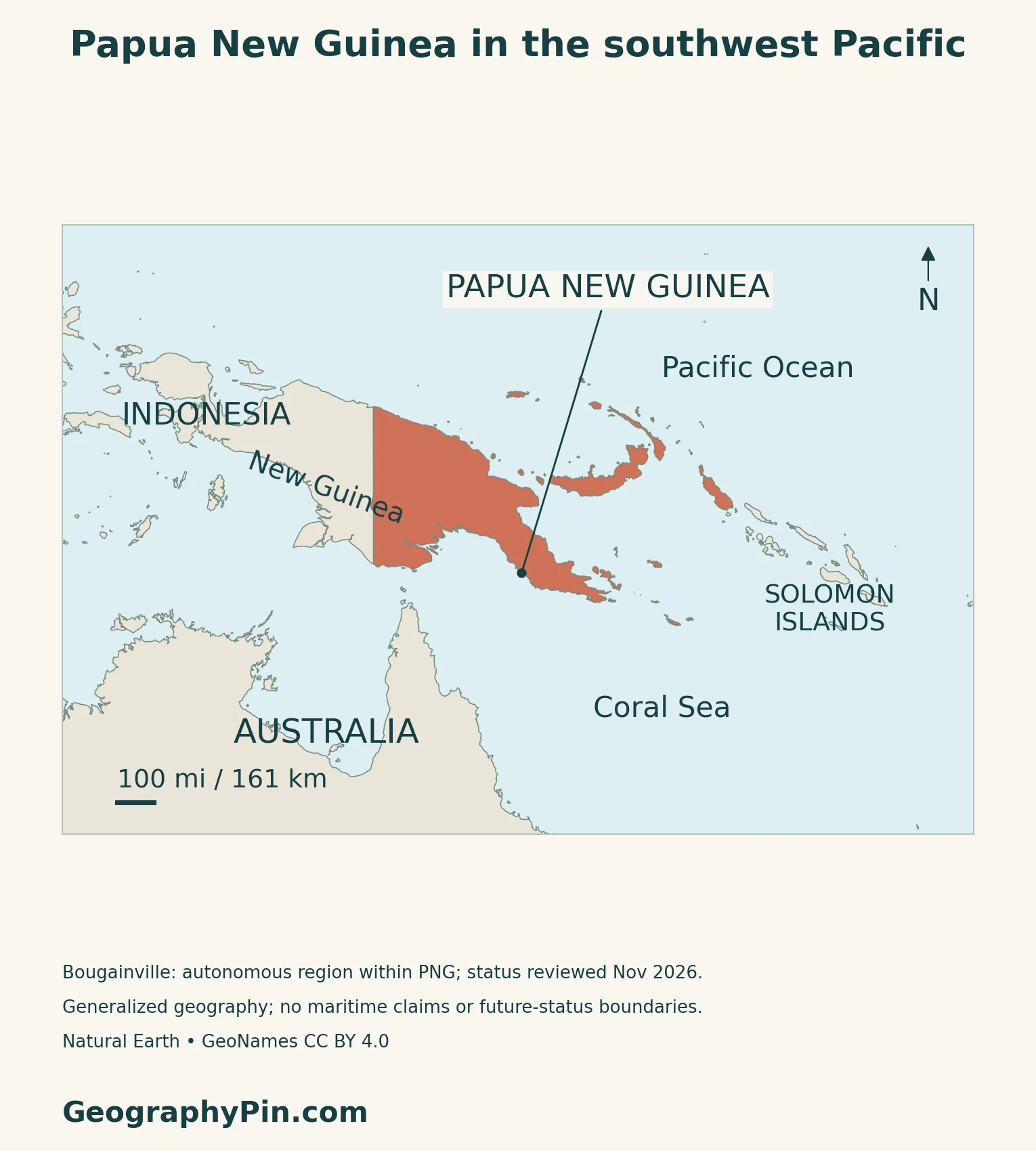
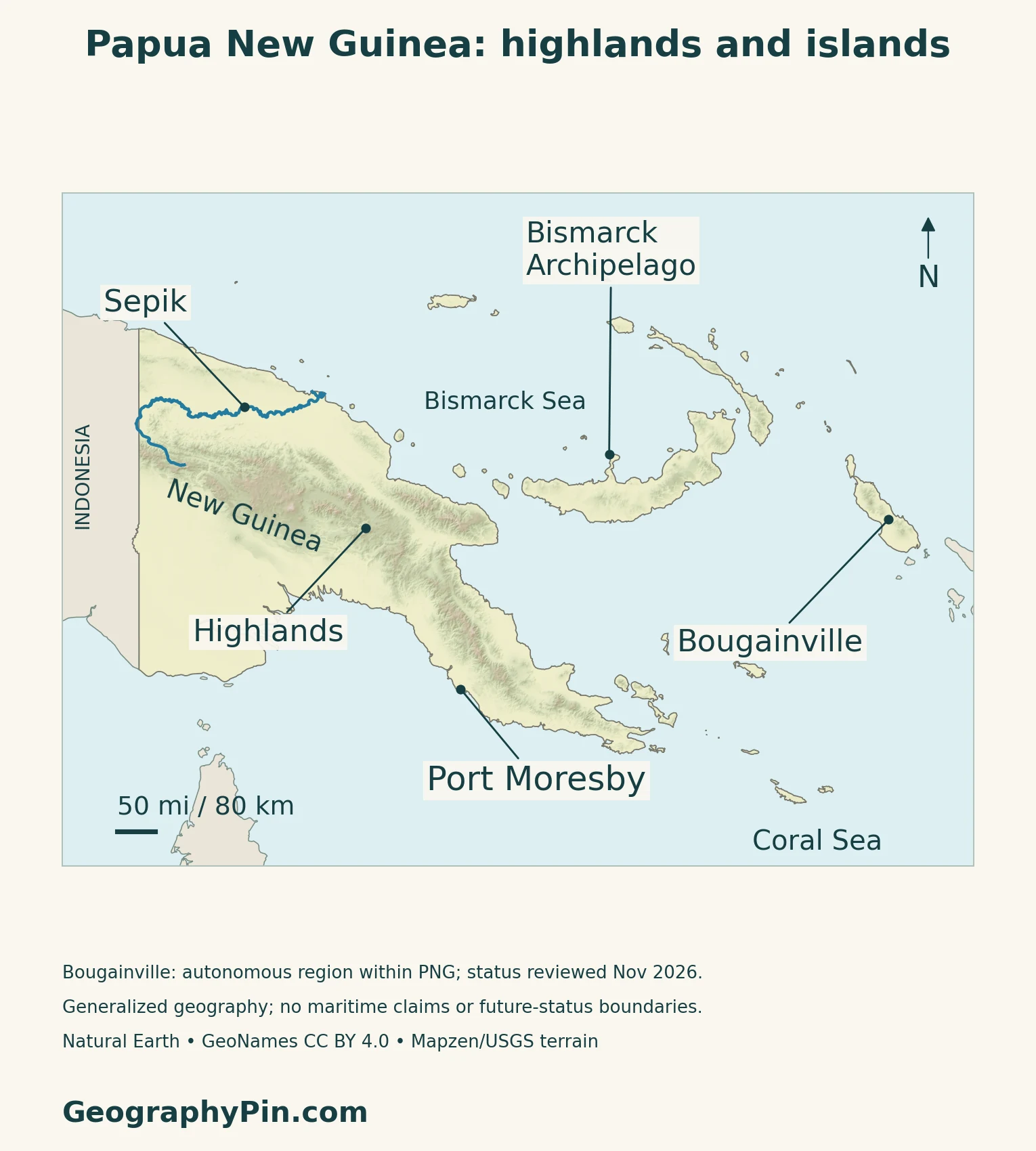
Papua New Guinea occupies eastern New Guinea and offshore islands in the southwestern Pacific; Indonesia occupies the island’s western part. Port Moresby is the capital. The Highlands contrast with the Sepik and Fly lowlands, while the Bismarck Archipelago and Bougainville extend the country beyond the main island. Bougainville remains autonomous within PNG during an ongoing political process.
How to use this article: Compare physical regions, understand rainfall contrasts, follow highland farming, or check population coverage.
1. The Country, the Island and the Offshore Groups
Papua New Guinea and New Guinea are not identical
New Guinea is the large island north of Australia. Papua New Guinea occupies its eastern part; the western part belongs to Indonesia. PNG also includes islands beyond the mainland, so neither “the whole island” nor “only the eastern mainland” describes the country correctly.
The Bismarck Archipelago lies to the north and northeast, with New Britain, New Ireland and Manus among its major islands. Other groups extend southeast from the mainland. For the wider regional setting, compare the Oceania countries and capitals guide.
Bougainville has autonomy within an ongoing political process
Bougainville is an autonomous region of Papua New Guinea. Its 2019 referendum favored independence, but the constitutional process remained under parliamentary consideration in November 2026. The referendum result did not itself create an independent country.
Geographic names also cross political categories: Bougainville belongs to the Solomon Islands archipelago geographically, but not to the neighboring sovereign state named Solomon Islands.
2. Highlands, River Plains and Volcanic Islands
Compare the main landscape settings
The Highlands run through the interior of New Guinea. In Papua New Guinea they include high ridges and enclosed upland basins, rather than a single continuous mountain wall. Farther south, broad lowlands contrast with the rugged interior.
| Region | Main setting | What to distinguish |
|---|---|---|
| Highlands | Interior mountain belt and basins | Valley floors differ from steep ridges |
| Sepik lowlands | Northern mainland river corridor | A drainage landscape, not an administrative region |
| Fly lowlands | Southwestern mainland | Low-lying river and wetland country |
| Bismarck Archipelago | Islands north and northeast of the mainland | Includes New Britain and New Ireland |
| Bougainville | Eastern island group | Geographic location and autonomous political status are different questions |
New Britain shows another kind of relief
Rabaul, at the northeastern end of New Britain, illustrates how volcanic landforms and coastal settlement can occupy the same place. Its caldera is a broad volcanic depression partly flooded by Blanche Bay; smaller cones occur around its margins.
NASA’s June 2010 satellite view shows settlements, vegetation and exposed volcanic ground around that bay. The major 1994 eruption forced Rabaul’s evacuation. This example explains a landscape shaped by both a useful harbor and volcanic hazards, rather than treating every offshore island as a low coral atoll.
3. Large Rivers and Contrasting Rainfall
From mountain catchments to sediment plains
The Sepik, Ramu, Fly and Purari carry sediment from mountain catchments into lowland plains and wetlands.
The Sepik basin also reaches across the international boundary into Indonesia. The Global Rivers Observatory began monthly sampling there in May 2019, studying a watershed that cannot be understood from a national outline alone. Its work provides a useful reminder that a drainage basin and a country are different geographic units.
Port Moresby is not a climate summary for the country
The PNG National Weather Service, Australian Bureau of Meteorology and CSIRO describe a pronounced wet–dry contrast at Port Moresby, but more consistent rainfall through the year at Kavieng in the northern islands. The West Pacific Monsoon supplies much of Port Moresby’s rain; convergence zones also influence the north.
The Highlands are cooler than coastal lowlands, while exposure to moist airflow affects rainfall.
A wet climate can still experience drought
The same climate research identifies El Niño years as generally drier and La Niña years as generally wetter in PNG. Drought, flooding and landslides are therefore not contradictory features of the country’s climate. Seasonal averages describe a pattern, not the weather that every village will experience in a particular year.
4. Farming, Settlement and Connections
Highlands are working landscapes, not empty barriers
At Kuk in the Western Highlands, archaeological evidence records long-term cultivation of a wetland landscape. Mounds and later drainage ditches show how people changed waterlogged ground for farming. UNESCO identifies the site as evidence of independent agricultural development over thousands of years.
This history matters when reading a relief map. A mountainous region can contain intensively used valley floors; the color marking high elevation does not mean that all the land is too steep to cultivate.
Different environments support different food systems
An Australian Centre for International Agricultural Research assessment distinguishes small islands, larger islands, lowlands and several highland zones. Altitude, seasonal water shortage and prolonged inundation all help define those environments.
Food production includes sweet potato, banana, taro, yam, cassava, coconut and sago, alongside locally marketed produce and export crops such as coffee and cocoa. No single crop or farming landscape represents the entire country. A coastal wetland, a highland garden and an island plantation face different combinations of soil, water and access.
Terrain and maintenance both shape connections
The World Bank’s evaluation of its 2008–23 work in PNG describes a fragmented road system and difficult access to markets and services. Rugged terrain and high construction costs are important, but the evaluation also stresses insufficient maintenance and institutional problems.
Those findings caution against explaining transport gaps only by mountains. Building a road is different from keeping it usable. The national map combines mainland routes with island and coastal connections, so a journey between two places can depend on several modes rather than a direct overland link.
Port Moresby lies on the southern coast, while Lae faces the Huon Gulf to the northeast. Their locations help explain why a map of the capital alone cannot show how the country’s settlements connect.
5. Dated Country Facts and Administrative Scope
| Item | Reference | Date or scope |
|---|---|---|
| Capital | Port Moresby | National government seat |
| Population | 10,185,363 | Final 2024 census; includes Bougainville |
| Surface area | 178,704 sq mi (462,840 km²) | UNData, 2023; not land-only area |
| Languages | English, Tok Pisin, Hiri Motu; PNG Sign Language also officially recognized | Hundreds of Indigenous languages are also spoken |
| Currency | Kina (PGK) | 100 toea per kina |
| Government | Constitutional monarchy with parliamentary government | National political system |
| Province-level divisions | 20 provinces, Bougainville autonomous region and National Capital District | 22 divisions, not 22 ordinary provinces |
What the 2024 census number counts
The final national census total is 10,185,363. Its reference date was June 16, 2024, but enumeration continued from June 17 to October 31 because of logistical difficulties. The census used a de facto approach, counting visitors where they were present rather than assigning everyone to their usual residence.
The National Statistical Office’s November 2026 launch of provincial final reports is a later publication of the 2024 census, not a new count for 2026.
Language recognition and everyday use are different
English is important in government and commerce, while Tok Pisin is widely used as a shared language and Hiri Motu has a trading-language history. These roles coexist with extensive Indigenous linguistic diversity.
PNG’s national report to the UN recorded sign language’s introduction as a fourth official language for government business programs in 2015.
Count administrative categories carefully
The National Capital District and Bougainville have distinct roles in the province-level total. Treating all 22 divisions as ordinary provinces hides that difference. Likewise, the country’s surface-area figure should not be relabeled as land area or confused with the area of the whole island of New Guinea.
PNG also illustrates why an island-country classification does not necessarily mean one country occupies one entire island: a state can share a large island and include many others.
What Did We Learn Today?
Papua New Guinea combines eastern New Guinea with offshore island groups, rather than covering the whole island. Highlands, sediment-rich river plains and volcanic islands provide contrasting settings for farming and settlement. Rainfall varies by location and year, while transport depends on terrain and maintenance. Bougainville’s autonomy and political process must be distinguished from independent statehood.
Sources & Data Notes
Population is the final 2024 census count, not a current projection. The census used a de facto approach and counting extended beyond the June reference date. Area is labeled according to the cited statistical series. Bougainville’s political process was reviewed November 2026. Climate information describes long-term regional patterns, not a forecast; the PACCSAP brochure predates its later online reposting. The Rabaul satellite example is from 2010. Transport analysis refers to the World Bank’s 2008–23 evaluation.
- PNG Department of Foreign Affairs: relief
- PNG Department of Foreign Affairs: drainage and soils
- PNG Department of Foreign Affairs: elevation and exposure
- PNG National Weather Service, Bureau of Meteorology and CSIRO: regional climate
- Global Rivers Observatory: Sepik basin and sampling
- NASA Earth Observatory: Rabaul Caldera, June 2010 imagery
- UNESCO: Kuk Early Agricultural Site
- ACIAR: agroecological zones and food systems, 2020 assessment
- World Bank Independent Evaluation Group: connectivity and maintenance, 2008–23
- PNG National Statistical Office: 2024 census final figures, October 2025
- NSO: provincial final-report release, November 2026
- UNData: Papua New Guinea surface area, 2023
- Australian DFAT: government and country context
- PNG Department of Foreign Affairs: languages and their uses
- PNG national report to the UN: sign-language recognition, paragraph 61
- PNG Department of Finance: province-level divisions
- Bank of Papua New Guinea: kina and toea
- Autonomous Bougainville Government: parliamentary process, November 13, 2026
- PNG national government: Bougainville debate, October 22, 2026
- PNG Department of Finance: Bougainville’s geographic island group
Map method: Original GeographyPin maps use public-domain Natural Earth country geometry v5.1.1 and rivers v5.0.0, real Mapzen/USGS elevation data and GeoNames reference points under CC BY 4.0. All 58 polygon components in the selected country record are retained; smaller islands can be generalized out of the source. The Sepik follows actual source geometry, including its cross-border course. Landform labels mark reference locations, not administrative boundaries. Bougainville is shown within PNG; status was reviewed November 2026. No maritime boundaries or future political borders are drawn. The cover is a decorative flag-series composition, not a separate territorial dataset.
