Libya’s geography connects a Mediterranean urban margin with a much larger desert interior. Northern uplands, inland oases and water transferred through pipelines make that relationship more complicated than a simple coast-versus-desert divide.
Libya is a North African country on the Mediterranean Sea, with Tripoli as its capital. Its physical geography includes coastal plains, separated northern uplands and a vast Saharan interior. Water availability helps shape settlement, but cities also depend on infrastructure connecting the coast with desert groundwater. The national outline does not show current political or military control.
How to use this article: Compare the physical settings, distinguish the pipeline system from a river, or check the population estimate’s date.
1. Locate Libya and Its Mediterranean Cities
Libya on the Mediterranean
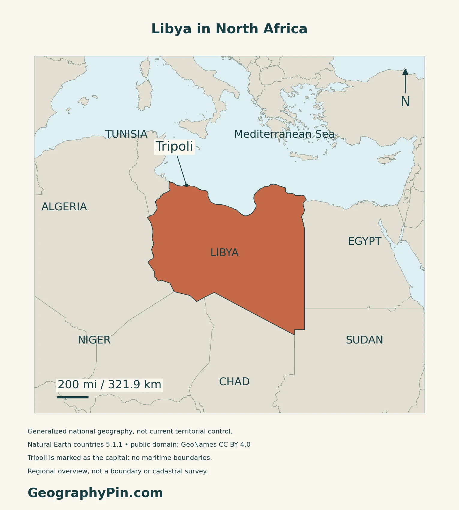
Libya lies on North Africa’s Mediterranean coast. Tripoli is its capital. The country’s outline locates the state, not the reach of any present political or military authority.
Tripoli and divided institutions
The 2011 Constitutional Declaration identifies Tripoli as the capital. That legal designation does not mean Libya has a single, fully unified institutional system: UNDP’s ongoing governance project describes political fragmentation and institutional duplication.
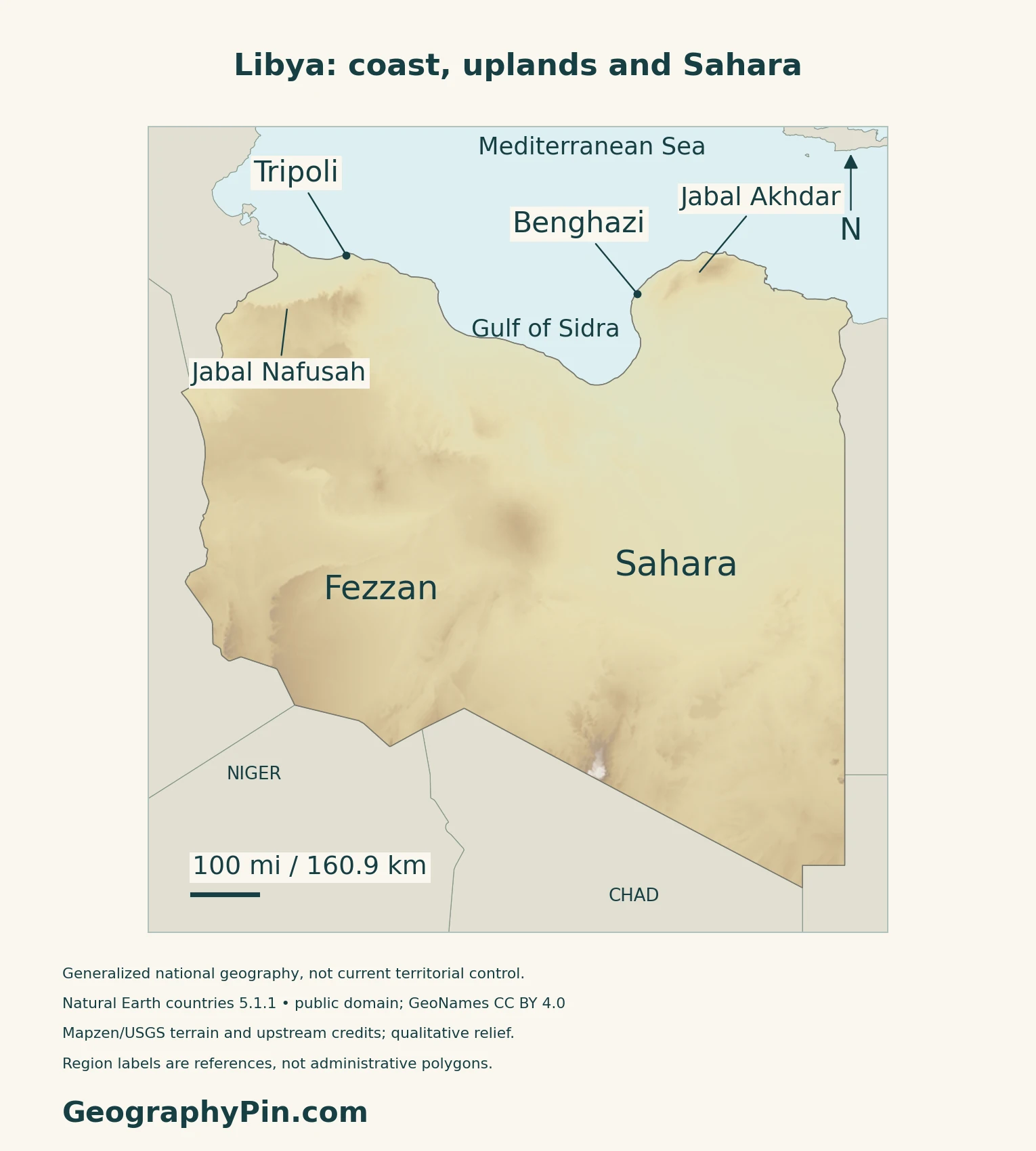
Read the maps from the coast inward: Tripoli marks the northwest, while Benghazi marks the northeast. The Gulf of Sidra forms the broad coastal indentation between the two sides.
2. Compare the Coastal Belt and Desert Interior
A landscape comparison
| Setting | What distinguishes it |
|---|---|
| Coastal plains | Lowland belts of varying width |
| Northern uplands | Jabal Nafusah in the west; Jabal Akhdar in the east |
| Interior depressions | Lower basins with oases in some locations |
| Southern and western mountains | Rocky uplands within the desert country |
These are FAO’s broad physical divisions, not administrative units.
Rock, dunes and traces of a wetter past
NASA’s Kufrah observations show sand dunes alongside rugged plateaus. Beneath that dry landscape lie traces of ancient drainage: a paleoriver is a former river system, not evidence of a flowing river today.
In the southwest, UNESCO describes Tadrart Acacus as a rocky massif adjoining Algeria’s Tassili landscape. Its rock art records changing animals, vegetation and human activities over long periods.
3. Understand Rainfall and Water Beneath the Desert
A wetter northern margin, not a rainy country
FAO describes dry summers and relatively wetter winters along the Mediterranean strip. The northern uplands receive more rain than the much drier interior.
The Great Man-Made River is infrastructure
Despite its name, the Great Man-Made River is a network of buried pipes, not a natural river crossing Libya. The project authority describes transfers from desert groundwater basins toward coastal areas. Its general description is not evidence that every component currently operates at its planned capacity.
NASA’s January 2024 account explains the connection between fossil groundwater, irrigated fields around Al Jawf and water transferred toward cities including Tripoli and Benghazi. Fossil water accumulated under older climatic conditions. Green agricultural circles in satellite images therefore do not, by themselves, show abundant modern rainfall.
Dry channels can still carry floodwater
IGRAC’s groundwater profile distinguishes the absence of permanent rivers from temporary flow in wadis, normally dry drainage channels. Intense rainfall can fill these channels rapidly. A dry-looking landscape and a lack of year-round rivers do not mean that surface-water hazards are absent.
4. Connect Settlement, Water and Economic Geography
Coastal cities and inland oases
Water infrastructure links the populated coast with desert resources, so the contrast is not simply “people in the north, nothing in the south.” Inland settlements and cultivated areas depend on particular water sources and connections rather than continuous humid conditions.
Ghadamès offers a different settlement example from the large coastal cities. UNESCO identifies its old town as an oasis settlement, with houses arranged vertically by function and covered passageways between them.
Oil dependence is not the same as broad prosperity
The World Bank’s country overview describes an economy strongly dependent on oil and gas, exposed to changes in production and international prices. It also identifies a large public sector and limited private-sector job creation. Resource production, the reliability of public services and the distribution of economic opportunities are separate questions.
For the wider regional setting, use the North Africa countries map. The Africa capitals reference provides the continent-wide lookup without extending this profile into a complete regional directory.
5. Check Dated Country Facts
| Item | Reference | Date or scope |
|---|---|---|
| Capital | Tripoli | 2011 Constitutional Declaration, article 1; also listed by UNData |
| Population | About 7.46 million | UNData 2025 projected estimate, medium-fertility variant |
| Surface area | 647,184 square miles (1,676,198 km²) | UNData figure for 2023; attributed surface-area convention |
| Language | Arabic is official | Article 1 also protects the languages of Libya’s cultural components as national languages |
| Currency | Libyan dinar (LYD) | UNData; current use corroborated by the Central Bank |
A projection, not a census count
The population figure is a modeled 2025 reference, not a 2026 census or a live count. UNData’s surface-area figure is reported on its own terms rather than silently substituted for other published area conventions.
Language and legal scope
Arabic’s official status does not make Libya linguistically uniform. Article 1 also recognizes the national-language status and cultural rights of its other communities. Legal status and the languages people use in particular places are different kinds of information.
What Did We Learn Today?
Libya combines a Mediterranean margin with desert landforms. Groundwater and pipelines connect inland resources with coastal cities; the population figure remains a dated projection.
Sources & Data Notes
Sources, dates and map methods
Population is UNData’s 2025 medium-fertility projection, while its surface-area figure is dated 2023. The Constitutional Declaration was read through the Libyan Law Society’s legal-text reproduction, not a newly verified consolidated constitution. UNDP supports the broad institutional-fragmentation description; the maps do not depict current control. Sources were checked in November 2026. Older FAO material supports stable terrain and broad seasonality, not present population, water withdrawals or infrastructure capacity. NASA’s article uses earlier satellite observations; it is not a live irrigation map. The project authority’s undated description supports the purpose of the pipeline system, not a current service guarantee.
- United Nations Statistics Division: Libya profile
- 2011 Constitutional Declaration, legal-text reproduction
- Central Bank of Libya: dinar-denominated exchange-rate page
- UNDP: Transformative Governance in Libya, ongoing 2025–2028 project
- FAO: Libya, older AQUASTAT physical-geography and climate reference
- NASA: Water Beneath the Sand, January 2024
- Man-Made River authority: project description
- IGRAC: Libya groundwater profile
- UNESCO: Old Town of Ghadamès
- UNESCO: Rock-Art Sites of Tadrart Acacus
- World Bank: Libya economic overview
Map method: Original maps use public-domain Natural Earth countries 5.1.1 and GeoNames reference coordinates (CC BY 4.0). Minor coastal details are generalized. Labels mark geographic references, not surveyed regions or territorial control. Qualitative Mapzen terrain retains Mapzen/USGS and upstream credits. Uncertain negative coastal-rim samples are withheld; inland negative terrain is retained, without replacement elevations. No rivers, pipelines or maritime claims are inferred. Scales use local WGS84 distances. The cover uses the same national outline and a complete separate public-domain Commons flag rendition; design and proportions are corroborated by Article 3 of the 2011 Constitutional Declaration.