On a Channel Islands day trip, picking Santa Cruz Island is only half the decision. Scorpion Anchorage and Prisoners Harbor put you on different parts of Santa Cruz, while the boat to East Anacapa lands beneath a cliff. Choose where you want to walk before you choose your sailing.
For a first Channel Islands day trip, choose Scorpion Anchorage on Santa Cruz Island for beach access and the Cavern Point loop. Choose Prisoners Harbor for the harbor overlook or a longer hike from that landing. Choose East Anacapa for a shorter network of bluff trails, if you can manage the boat ladder and steep stairs. Book both boat legs for the named landing; do not expect to switch islands on the day.
1. Choose Your Landing Before You Book
The quickest way to narrow the choices is to decide what you want to do after stepping off the boat. The first three landings below are the practical starting points for an ordinary day trip. Departure times and landings still depend on the date and sea conditions.
| Landing | Best fit | What changes the decision |
|---|---|---|
| Scorpion Anchorage, Santa Cruz | First visit, beach and bluff loop | Ventura; usually a little over an hour by boat one way. Cavern Point loop is 2 mi round trip from Scorpion Beach. |
| Prisoners Harbor, Santa Cruz | A quieter harbor and an inland viewpoint | Ventura; about 1½ hours direct, or 2 hours or more with a stop. The short harbor overlook walk is 0.5 mi round trip. |
| Landing Cove, East Anacapa | Compact open-bluff trails and island views | Ventura or Oxnard, depending on sailing; about an hour one way. A ladder transfer and more than 150 stairs come before the clifftop trails. |
| Santa Barbara Island | Not a substitute for a standard mainland day trip | As checked November 21, 2026, the operator listed no trips because of landing damage. |
If someone in your group wants a short easy walk once ashore, the half-mile harbor walk is useful only if they can manage Prisoners Harbor’s boat-to-pier transfer. If the transfer is the deciding factor, compare that ladder with Scorpion’s adjustable pier platform and ramp before booking rather than choosing by mileage alone.
2. East Anacapa: The Stairs Come First
Regular landing visits go to East Anacapa, at Landing Cove on the easternmost islet. A vessel crew helps passengers transfer to a ladder at the dock; the climb varies with the tide. More than 150 stairs then lead up from the dock. Think about coming back down to the boat as well as going up. There is no lift, and the crew can decide conditions are unsuitable for landing.
Once on top, the park lists Inspiration Point as a 1.5 mi (2.4 km) round trip from the visitor center. That trail distance starts after the stair climb. It looks west along the string of islets, but it is not a route to Middle or West Anacapa. Pack water: the island does not have a drinking-water supply for visitors.
3. Santa Cruz: Two Landings, Two Different Days
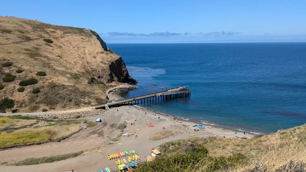
Scorpion Anchorage is near the eastern end of Santa Cruz Island. From its pier, the ranch area, beach and Cavern Point loop are in the same part of the island. The park measures the loop at 2 mi (3.2 km) round trip from Scorpion Beach. The modern landing uses a step from the boat to an adjustable platform, then a ramp onto the pier. Check with the park or operator if someone needs transfer assistance or a beach wheelchair. Drinking water is at the campground, not the pier or visitor center.
Prisoners Harbor is farther west on the north coast, near land managed by The Nature Conservancy. Its normal transfer is from the boat to a ladder. The park’s short harbor-overlook walk is 0.5 mi (0.8 km) round trip; there is no potable water at this landing. The park lists Pelican Bay as 4 mi (6.4 km) round trip, but ordinary concessionaire passengers may use that trail only with operator staff. The operator also warns that a guided outing can turn back before reaching the bay.
The two landings are not connected by a public road shuttle. The park’s backcountry guide gives 13.2 mi (21.2 km) one way via the Del Norte Trail and 14.2 mi (22.9 km) one way via Navy Road. The park describes this as a point-to-point backpacking option; treat it separately from a short visit that returns to the same pier.
4. Which Mainland Harbor Should You Drive To?
Ventura Harbor: Island Packers check-in is at 1691 Spinnaker Drive, Suite 105B, Ventura. This is the usual departure for Scorpion Anchorage and Prisoners Harbor.
Channel Islands Harbor, Oxnard: Island Packers check-in is at Marine Emporium Landing, 3550 Harbor Boulevard, Oxnard. East Anacapa can leave from either harbor; use the exact mainland harbor shown on your ticket.
Return boarding: Check the island landing and pickup time on the return reservation before choosing your walk. On a normal day trip, return to the pier you booked; a boat that calls at two landings does not give you a flexible return.
The operator locates Anacapa roughly 12–14 mi (19–23 km) offshore and Santa Cruz about 20 mi (32 km) from Ventura Harbor. Those are orientation distances, not measured length for every sailing. On the water, a Prisoners Harbor boat can stop at Scorpion first. The time of your return pickup matters more for choosing a walk than the direct distance to the island.
You drive to a mainland harbor, then board a passenger boat and continue on foot. The island maps may show old ranch or service roads. They are not driving routes for day visitors. Use the published start point and the wording one way or round trip when setting a turnaround time.
5. Island Transfers, Weather and Seasonal Access
For a normal day ticket, do not plan to hop between Anacapa and Santa Cruz. Island Packers does show some scheduled transfers for campers on select dates, including Santa Cruz to Santa Rosa and some transfers between the two Santa Cruz landings. Those are booked separately; they are not a walk-up day ferry. A boat that stops at Scorpion on the way to Prisoners Harbor is not permission to get off and catch a later boat.
Access checked November 21, 2026: Island Packers describes Anacapa and Santa Cruz as generally available year-round, with schedules and landings subject to sea conditions. Its Santa Barbara Island booking page lists trips as unavailable because of damage at the landing. The park alert distinguishes a closed dock from restricted landing at the adjacent rocky ledge. That is not a normal concessionaire landing option. Do not confuse Santa Barbara Island with the mainland city or visitor center. Santa Rosa and San Miguel are farther out and have more limited, seasonal concessionaire service.
Before leaving, check both the operator’s sailing status and the park’s current conditions. On your ticket, confirm the mainland harbor, exact island landing and return pickup. Then choose a walk that leaves time to get back to that pier. If a landing is what you want, check that the trip is not a non-landing wildlife cruise.
Frequently Asked Questions
Can I change islands without returning to the mainland?
Not as an ordinary hop-on day trip. Some prearranged camper shuttle legs connect selected islands on selected dates. Do not assume your return ticket can be moved to a different island or pier.
Which Santa Cruz Island landing should I choose?
Choose Scorpion Anchorage for the beach, ranch area and Cavern Point. Choose Prisoners Harbor for the harbor-overlook walk, access toward Del Norte or a confirmed guided outing on the Pelican Bay Trail.
Do the map distances include the return?
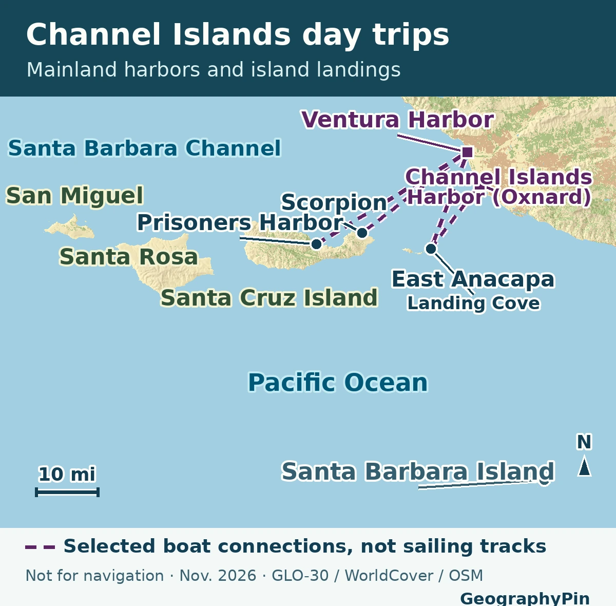
The short walks listed here are round trip from their named starts. The 13.2- and 14.2-mile routes between the two Santa Cruz landings are one way. The dashed map lines are boat connections, not driving routes or distances.
What Did We Learn Today?
Scorpion and Prisoners Harbor lead to different parts of Santa Cruz Island. East Anacapa adds a ladder and stair climb before the trail even begins. The harbor, landing and return time on the ticket determine which walk makes sense.
Sources & Data Notes
- National Park Service: Directions & Transportation, official park maps, mobility and landing details (updated September 16, 2026), current conditions, and active park alerts. The current mobility page and the operator count the Anacapa stairs slightly differently; both describe more than 150.
- Island Packers: Anacapa landing and island conditions, Santa Cruz landings, one-way boat times and hikes, check-in addresses, camper shuttle routes, and Santa Barbara Island service notice. Check the Ventura route listings or the particular reservation for the actual trip; no seat or landing availability is implied by the map.
- NPS hiking sources: East Anacapa hiking map, eastern Santa Cruz hiking map, Pelican Bay restriction, and one-way backcountry distances. The August 2026 campground announcement describes point-to-point hiking as a backpacking opportunity. Metric distances rounded from the U.S. sources.
- Original GeographyPin map, UTM 11N. Location markers correspond to the park maps and operator’s directions, using mapped harbor/landing points from © OpenStreetMap contributors, ODbL; the California Ocean Protection Council intertidal report confirms the Santa Barbara landing. Coast, water and land cover were styled from ESA WorldCover 2021 v200, CC BY 4.0. Straight connectors show selected booking pairs for orientation and are not charts, vessel routes, public footpaths or evidence of departures on a given date.
- Produced using Copernicus WorldDEM-30 © DLR e.V. 2010-2014 and © Airbus Defence and Space GmbH 2014-2018 provided under COPERNICUS by the European Union and ESA; all rights reserved. Copernicus GLO-30 terms. The organisations in charge of the Copernicus programme by law or by delegation do not incur any liability for any use of the WorldDEM-30.
- Photograph: Mx. Granger, “Santa Cruz Island 6”, Scorpion Anchorage on July 1, 2024, Wikimedia Commons, CC0 1.0. Cropped, resized and converted to WebP.
