Follow Bilbao’s river downstream and the streets give way to docks and breakwaters, but the name on the port does not tell you which town you are in. The estuary links the old city to the coast across several municipalities.
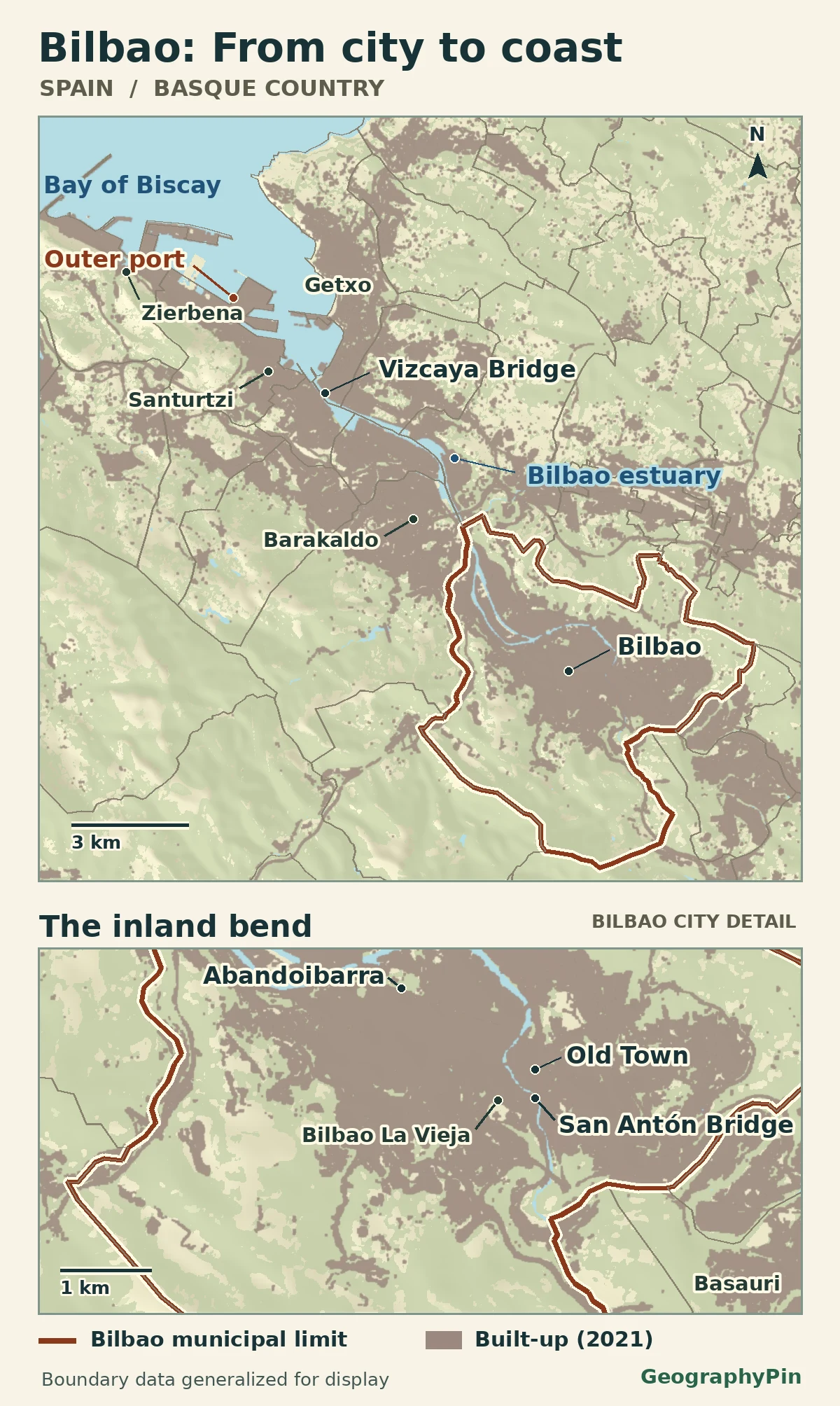
Bilbao lies in Bizkaia, in Spain’s Basque Country, on the inland reach of the Nervión–Ibaizabal estuary. The Old Town sits at a bend in the waterway, southeast of the outer harbor. The present-day Port of Bilbao is not wholly inside Bilbao municipality: major harbor works extend to the coast around Santurtzi and Zierbena.
How to use this article: Try the city boundary map, see the waterway to the outer port, or go to the two population definitions.
Where Bilbao sits on the map
Trace the water northwest to the coast
Bilbao, or Bilbo in Basque, is the capital of Bizkaia in northern Spain. The main built-up strip occupies a valley that winds between hills. Downstream, the waterway generally turns northwest toward El Abra, the coastal bay that opens to the Bay of Biscay. This is why “in Bilbao” on a transport or port label does not always mean inside the city boundary.
Start with the thick municipal outline, not the edge of the built-up color. The outline includes some hillside land away from the river, while the built-up corridor crosses it. Barakaldo downstream and Basauri upstream are separate municipalities even where the settlement pattern looks continuous at this scale.
Near Basauri, the Nervión (Nerbioi) and Ibaizabal join. Sources refer to the lower waterway as the Bilbao estuary, the Nervión estuary or the Ibaizabal estuary. This map uses “Bilbao estuary” for the tidal corridor rather than choosing one river name to cover both upstream branches.
The Old Town and the city bend
Find San Antón, then look across the water
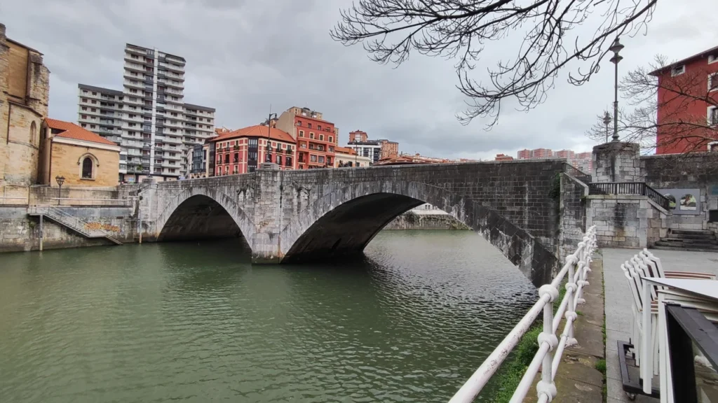
The Casco Viejo, or Old Town, is the historic core in today’s Ibaiondo district. The compact street pattern around the Siete Calles (Seven Streets) sits by the east side of the river bend. San Antón church and its bridge are good markers at the southern end of the old quarter; the Ribera market runs along the river nearby.
Across the water is Bilbao La Vieja. Despite its name, this is not the same neighborhood as the Casco Viejo. Moving downstream, the river passes the more open city-center waterfront of Abandoibarra and then bends around the Deusto area. These names describe separate places within the municipality, not a route that leaves the city as soon as it crosses a bridge.
The change along the banks is visible without treating the city as one old quarter and one new quarter. In the historic bend, buildings face the water at close quarters. Farther down, wider former dock areas offered space for redevelopment. The Guggenheim Museum Bilbao was built on a former industrial wharf at Abandoibarra between 1993 and 1997. Go farther still and the same river remains an industrial and port corridor in its own right.
Where the outer port actually sits
Separate the city waterfront from the harbor works
Follow the lower estuary past Erandio and the industrial stretch by Barakaldo and Sestao. The Vizcaya Bridge, completed in 1893, connects Portugalete and Getxo across the river near the mouth. It is a useful map marker: you have left the central city, even though you are still looking at the Bilbao estuary.
The harbor opens beyond this crossing into El Abra. Its outer works include the Zierbena breakwater and the Santurtzi counter-breakwater. The Port Authority dates the large outer expansion to 1992. Reclaimed land and new berths extended maritime operations toward the coastal bay; they did not extend the municipal limits of Bilbao.
“Port of Bilbao” refers to a port system with facilities along the estuary and in the outer harbor, not a piece of land defined by Bilbao’s municipal boundary. The map locates the outer works but does not draw the port authority’s full legal service area or imply that all working berths operate there.
How many people live in Bilbao?
Use two numbers from the same table
The Spanish transport ministry’s Áreas Urbanas en España 2024 edition gives both counts on the same 2023 population basis: 345,235 people in the municipality and 903,839 people in its 35-municipality Bilbao urban area. Bilbao itself accounts for about 38% of that total. The larger figure includes the city; do not add the two together.
| Area | Population | What is included |
|---|---|---|
| Bilbao municipality | 345,235 | One municipality |
| Bilbao urban area | 903,839 | Bilbao and 34 other municipalities |
This is the transport ministry’s wider urban-area definition, not the separate Gran Bilbao statistical comarca or INE’s functional urban area based on commuting links. Those boundaries can differ without any disagreement over where the city hall is. The gray built-up areas on the map show physical settlement and developed land, not every municipality counted in the ministry report.
Frequently Asked Questions
Is the Port of Bilbao entirely inside the city of Bilbao?
No. Its infrastructure stretches down the estuary, and the outer works around Santurtzi and Zierbena are outside Bilbao municipality.
Is Bilbao directly on the open coast?
The city center is inland on the tidal estuary. The waterway reaches the coast through El Abra, downstream of the central city.
Are Barakaldo and Getxo neighborhoods of Bilbao?
No. Both are separate municipalities, even though they are in the wider urban area and both sit along the estuary corridor.
What Did We Learn Today?
Bilbao grew around an inland bend of an estuary that links it to the Bay of Biscay. The built-up corridor and outer harbor cross municipal boundaries. For population comparisons, keep the city and the wider urban area separate and use counts from the same year and definition.
Sources & Data Notes
The population figures are for 2023 as printed in the transport ministry’s 2024 edition; the urban area is not outlined on the map. The map uses generalized municipal boundaries from ehmap contributors, based on Instituto Geográfico Nacional de España (CC BY 4.0). Built-up and water classes use © ESA WorldCover project 2021 / Contains modified Copernicus Sentinel data (2021) processed by ESA WorldCover consortium (CC BY 4.0). Terrain via Mapzen Terrain Tiles: European terrain produced using Copernicus data and information funded by the European Union, EU-DEM layers. The map is not a statistical settlement boundary or a cadastral survey. Featured photo: San Antón Bridge, Mentxuwiki, 22 February 2024, resized and converted to WebP; adaptation under CC BY-SA 4.0.
- Spanish transport ministry: Áreas Urbanas en España 2024, Bilbao municipality and urban area rows (2023)
- INE: Urban Indicators methodology and separate functional urban-area scope
- Basque Government: Nervión–Ibaizabal confluence and naming
- Bilbao municipal tourism: Casco Viejo and Ibaiondo
- Guggenheim Museum Bilbao: the old industrial wharf and waterfront construction
- ehmap contributors and IGN España: source and rights for municipality boundaries
- ESA WorldCover 10 m 2021 v200, water and built-up land
- Mapzen Terrain Tiles: relief layer, accessed November 21, 2026
- UNESCO: Vizcaya Bridge and the municipalities it connects
- Port Authority of Bilbao: stages of port expansion
- Port Authority of Bilbao: outer-port infrastructure
- Photo source and author: Mentxuwiki, San Antón Bridge