Antigua and Barbuda is often introduced as a twin-island country, but its geography extends beyond those two names. The principal islands have contrasting terrain, Redonda adds a much smaller volcanic landscape, and the sea connects places that face different water, coastal and conservation challenges.
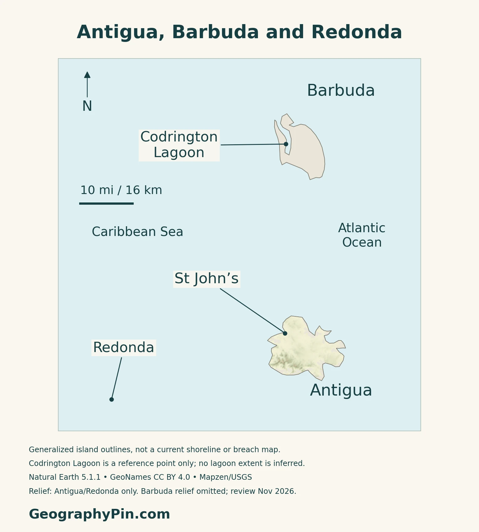
Antigua and Barbuda is one Caribbean country with two principal islands and smaller islands including Redonda. Antigua combines volcanic hills, a central plain and limestone terrain; Barbuda is a low limestone island with Codrington Lagoon on its western side. St. John’s, on Antigua, is the national capital, while Codrington is Barbuda’s administrative center.
How to use this article: Compare the islands, understand Codrington Lagoon, explore water supply, or check the population projection.
1. Locate the Islands and Define the Country
One country, several islands
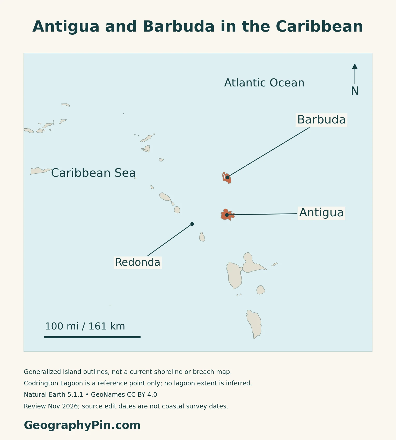
Antigua and Barbuda is one sovereign country in the Leeward Islands of the eastern Caribbean. Antigua and Barbuda are its two principal islands, but the state also includes Redonda and smaller offshore islands.
Barbuda lies north of Antigua, while Redonda is farther to the southwest. Water separates the islands, making sea and air connections important to movement between them. The wider Caribbean countries and territories map places the state within the surrounding island chain.
St. John’s is the national capital
St. John’s, on Antigua, is the capital and national seat of government. Codrington serves as Barbuda’s administrative center, including the offices of the Barbuda Council.
2. Different Islands, Rocks and Coastlines
Read the islands as different landscapes
| Island | Physical character | What to notice |
|---|---|---|
| Antigua | Volcanic hills, central plain and limestone terrain | A varied interior and deeply indented coast |
| Barbuda | Low-lying limestone landscape | Codrington Lagoon, sandy coastal features and karst cavities |
| Redonda | Small volcanic island southwest of Antigua | A distinct landscape within the wider state, not part of Antigua island |
The UWI Seismic Research Centre distinguishes three main geological units on Antigua: the older volcanic rocks in the southwest, the mixed sedimentary rocks of the Central Plain Group, and younger limestone formations in the north. This records a change from volcanism to marine deposition; it does not mean that Antigua currently has an active volcano.
Codrington Lagoon is a changing coastal system
The lagoon lies on western Barbuda, with mangroves along its eastern margin and Codrington beside it. Research published in 2023 documents how Hurricane Irma in 2017 opened inlets through the western sand barrier. Its analysis combines historical maps, satellite imagery through 2021 and post-storm field observations.
An IUCN assessment published in February 2026 reports that the breach remained open and had expanded, altering exchange with the sea and the lagoon’s ecological character. An older map showing an uninterrupted barrier should therefore not be read as a current shoreline survey.
The protected wetland is more than open water
The Ramsar site description includes mangroves, seagrass, tidal flats, beaches and reef habitats, supporting species such as juvenile lobster, fish, turtles and nesting seabirds. The designated site covers about 8,896 acres (3,600 hectares), not simply the lagoon’s water surface.
That description’s ecological information dates from 2006. It identifies the wetland’s importance, while the later research and IUCN assessment explain changes that followed Irma.
3. Rainfall, Drought and Water Supply
A seasonal climate with local differences
The Caribbean Regional Climate Centre’s historical station records for Antigua show a wetter peak from September to November and a drier peak from January to March. The periods differ by station: 1979–2013 at G. Castle and 1971–2014 at V.C. Bird.
The 2024 Country Hydromet Diagnostic describes a dry tropical maritime climate influenced by easterly trade winds, with drought and tropical cyclones among the major hazards.
Seawater, stored rain and groundwater all matter
APUA identifies three sources for water production on Antigua: seawater, rain collected in ponds and dams, and groundwater reached through wells. Reverse osmosis removes salt from seawater, but it requires substantial electricity. Drought can reduce the availability of the less energy-intensive surface and groundwater sources.
APUA also distinguishes installed plant capacity from actual output. Sea conditions, equipment and maintenance can affect production, so adding the capacities of several plants does not establish how much water reaches households on a particular day.
Producing water is only part of the system
In its September 16, 2026 report, Cabinet emphasized storage, transmission and distribution alongside expanded desalination. It described continuing work on tanks, pumps and aging pipelines to improve delivery. That makes water security an infrastructure question as well as a rainfall question: a plant, storage reservoir and household connection must function as a system.
4. Harbors, Conservation and Island Connections
English Harbour links topography and history
The Antigua Naval Dockyard occupies deep, narrow bays protected by surrounding hills and a restricted entrance. UNESCO explains how those natural features supported the construction and defense of a British naval facility in the eastern Caribbean.
The dockyard was built and operated through the labor and skills of enslaved Africans.
Redonda connects terrestrial and marine conservation
Conservation partners removed invasive rats and relocated feral goats from Redonda in 2017. Fauna & Flora reports subsequent recovery in vegetation, native reptiles and seabirds. Continuing work includes monitoring and biosecurity to prevent invasive animals from returning.
The Redonda Ecosystem Reserve, designated in 2023, encompasses both the island and surrounding marine habitats. Its roughly 116 square miles (300 km²) of protected land and sea must not be mistaken for the size of Redonda island itself.
Connections support a tourism-dependent economy
The IMF’s May 2026 assessment identifies tourism, construction and international connections as important parts of the economy. It also highlights vulnerability to external demand, commodity prices and capacity constraints, and the value of more effective port and customs processes.
The government’s September 2026 airport-planning discussion covers both V.C. Bird International Airport on Antigua and Barbuda International Airport. Separate islands need their own access infrastructure even though they form one state. The North American countries and capitals guide provides the wider regional reference.
5. Country Facts, Population and Administration
| Item | Reference | Date or scope |
|---|---|---|
| Capital | St. John’s | On Antigua; national seat of government |
| Population | 106,365 | National medium-scenario projection for 2026, based on the 2011 census |
| Surface area | About 171 sq mi (442 km²) | UN reference, 2023; national surface area, not maritime jurisdiction |
| Official language | English | Current government reference |
| Currency | Eastern Caribbean dollar (XCD) | Shared regional currency |
| Government | Constitutional monarchy with parliamentary government | Current monarchy confirmed in November 2026 |
| Administrative divisions | Six parishes and two dependencies | Parishes on Antigua; dependencies Barbuda and Redonda |
A projection, not a new census count
The National Bureau of Statistics displays the 2026 figure through its population-projection series. The underlying medium scenario was published in the 2011 census demographic report in June 2017 and starts from the resident population, rather than a count of citizens alone.
On October 15, 2026, the bureau reported that fieldwork for the 2025 Population and Housing Census was still underway.
Parishes and Barbuda’s local government
Antigua’s six parishes are Saint George, Saint John, Saint Mary, Saint Paul, Saint Peter and Saint Philip. Barbuda and Redonda are classified as dependencies within the country. Barbuda has a Council responsible for local government; the national government remains based in St. John’s.
What Did We Learn Today?
Antigua, Barbuda and Redonda belong to one country but differ in terrain and ecological character. Antigua’s mixed geology contrasts with Barbuda’s low limestone landscape, while Codrington Lagoon shows how storms can reshape a coast. Water supply depends on both natural resources and infrastructure, and Redonda illustrates the relationship between island restoration and marine protection. Population projections, census results and protected-area sizes need distinct dates and definitions.
Sources & Data Notes
The 2026 population is the national medium-scenario projection based on the 2011 census, published in the June 2017 demographic report. The October 15, 2026 bureau update states that 2025 census fieldwork was ongoing. Surface area is the UN’s 2023 reference, not maritime jurisdiction. Rainfall comparisons retain the historical station periods. Ramsar ecological information dates from 2006; the 2023 lagoon study and February 2026 IUCN assessment provide later change context. Water-source descriptions do not assert current plant output or uninterrupted supply. The September 2026 Cabinet report is accessed through an official embassy republication; proposed work is not described as completed. The 2013 administrative guide is corroborated by the government parish page, not treated as a new legal survey.
- UWI Seismic Research Centre: Antigua and Barbuda geology
- Original research, 2023: Codrington Lagoon morphology and Hurricane Irma
- IUCN: Caribbean wetlands assessment, February 2026
- Ramsar: Codrington Lagoon designated site; ecological information dated 2006
- Caribbean Regional Climate Centre: Antigua historical station rainfall
- Country Hydromet Diagnostic: Antigua and Barbuda, 2024
- APUA: Water sources and installed capacity distinction
- Government Cabinet report, September 16, 2026; official embassy republication
- UNESCO: Antigua Naval Dockyard and Related Archaeological Sites
- Fauna & Flora: Redonda restoration and reserve management
- Environmental Awareness Group: Redonda Ecosystem Reserve
- IMF: Article IV consultation, May 2026
- National Bureau of Statistics: Population projections to 2026
- 2011 census demographic profile, June 2017; medium-scenario projection table
- NBS: Census fieldwork update, October 15, 2026
- UN Data: Surface area, capital and currency; area reference 2023
- Official CHOGM 2026 country information: Language and currency
- Government Information Service: Parishes and settlement roles
- OAS government-reviewed public-management guide, 2013: Administrative framework
- Official independence address, November 1, 2026: Constitutional monarchy
Map method: Original GeographyPin maps retain Antigua, Barbuda and Redonda from Natural Earth 1:10m countries version 5.1.1, public domain. These generalized island footprints are not current shoreline surveys. Place locations use GeoNames under CC BY 4.0. Codrington Lagoon is shown only as a reference point, not an enclosed lagoon or sand-barrier polygon. Actual elevation shading on Antigua and Redonda uses Mapzen Terrain Tiles, with USGS and upstream attribution. Invalid negative coastal cells and a small surrounding buffer are transparent, not replaced with invented elevations. Barbuda relief is omitted because the coarse raster contains implausible coastal values; its neutral outline does not depict elevation. Redonda terrain is especially coarse and supplies no summit measurement. The physical map uses one scale for all three islands. The decorative featured outline retains their relative source positions and uses FlagCDN national-symbol artwork, checked against the government’s National Symbols description. No endorsement is implied.