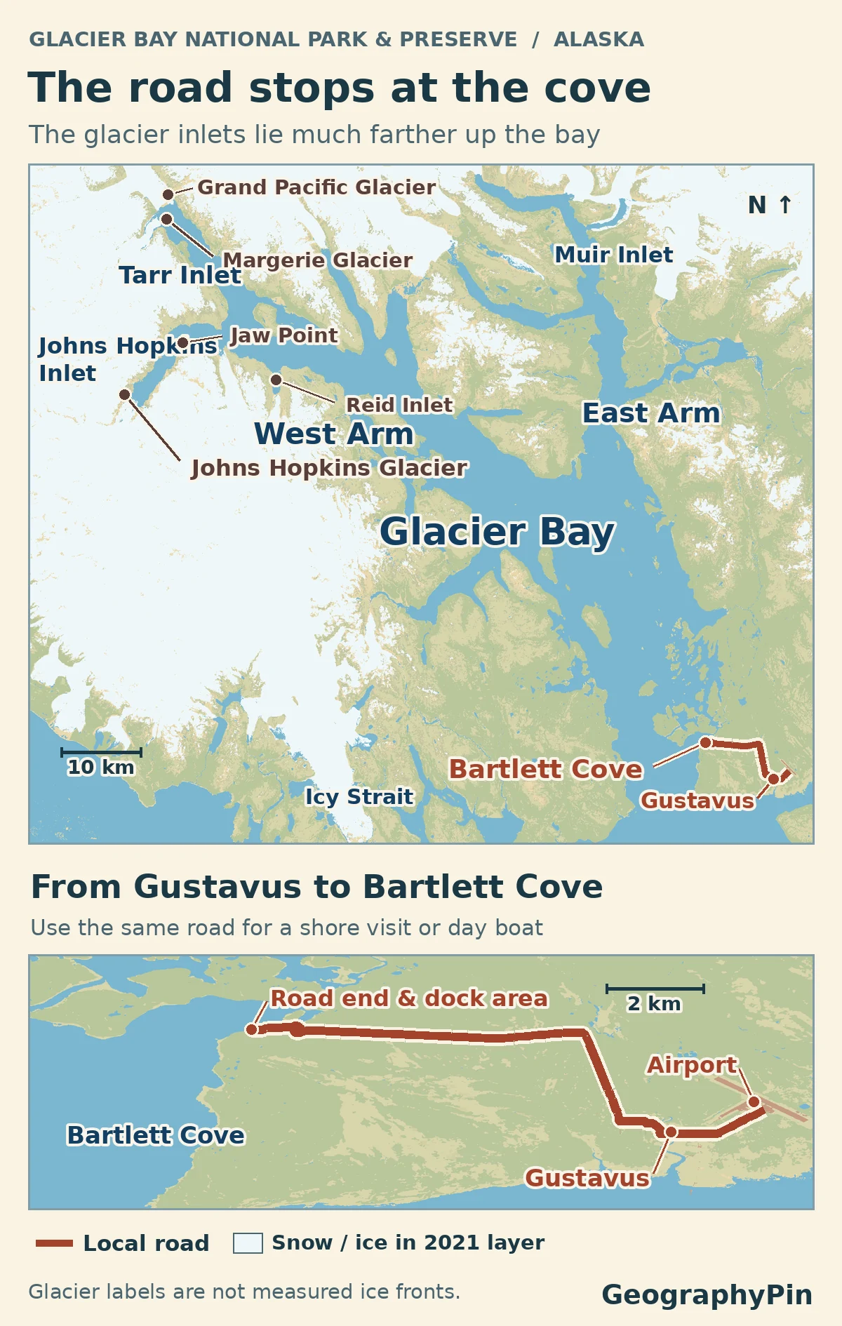
The road into Glacier Bay ends at Bartlett Cove, not at the glaciers. Use this map to find the drive from Gustavus, then follow the two arms of the bay north to see why an outing to the tidewater glaciers is a separate trip on the water.
Drive from Gustavus to Bartlett Cove for trails and the day-boat dock. No road continues to Tarr Inlet or Johns Hopkins Inlet. Choose an upper-bay boat trip to see those glacier areas; weather, ice and wildlife protections can change where a vessel goes.
Pick your starting point: Open the bay map and visit comparison, choose a walk at Bartlett Cove, or see where the West Arm divides.
Where the road ends and the glacier inlets begin
Map the road to Bartlett Cove
Gustavus is the arrival town, Bartlett Cove is the park’s shore base, and the upper bay is where walls of glacier ice meet some of the inlets. The important separation is between Bartlett Cove and that upper bay. A road reaches the former; neither the West Arm nor the East Arm has a road from Gustavus. Juneau is not connected to Gustavus by road either.
| Your plan | How you reach it | The decision that matters |
|---|---|---|
| Walk the shore at Bartlett Cove | Fly or take the ferry into Gustavus, then travel by local road | Arrange ground transport; the short trails start at the cove. |
| See the upper bay on a day trip | Board the seasonal excursion at Bartlett Cove’s public-use dock | Give the boat its own day. A particular glacier is not guaranteed. |
| See the bay on a cruise | Arrive aboard the ship as part of a Southeast Alaska itinerary | Cruise ships do not dock in the park. A shore walk requires a separate journey. |
From Gustavus to a walk at Bartlett Cove
Allow about 10 road miles for the transfer from the Gustavus area to the Bartlett Cove developed area, where the park lodge, visitor center and public-use dock sit close together. That distance is a transfer, not the distance of a hike. If arriving in Gustavus by air or ferry, arrange a ride before relying on a tight connection.
Forest Loop or the Tribal House shore path
Start the one-mile Forest Loop near the lodge or the boat ramp. The walk joins a stretch of rainforest with the shoreline; the Park Service allows roughly 30 to 90 minutes. A separate shore path, the Łingít Trail, passes Xunaa Shuká Hít, the Huna Tribal House. Choose that path if you want to spend your limited time on the shore rather than tracing the forest loop. Indoor opening hours are separate from access to the paths. The visitor center is upstairs in the lodge; the Visitor Information Station is a separate stop by the public-use dock. If a facility you want is closed, the visit may still work as a walk, but confirm weather and trail conditions before counting on that alternative.
The West Arm forks toward Tarr Inlet and Johns Hopkins Inlet
Which inlets are in the West Arm?
North of Bartlett Cove, the fjord system opens into two main arms. The East Arm turns toward Muir Inlet. The West Arm reaches the better-known glacier viewpoints around Tarr Inlet and Johns Hopkins Inlet. Those two West Arm destinations are next to one another on a broad map, but a vessel sees them along different stretches of water.
Tarr Inlet: Margerie Glacier meets the inlet near its northern reach. Grand Pacific Glacier lies farther up the same inlet. The two glaciers once touched; the National Park Service’s glacier profile records their last joining in 1992 and describes Grand Pacific’s front as grounded. Do not identify every glacier beside an inlet as a tidewater glacier.
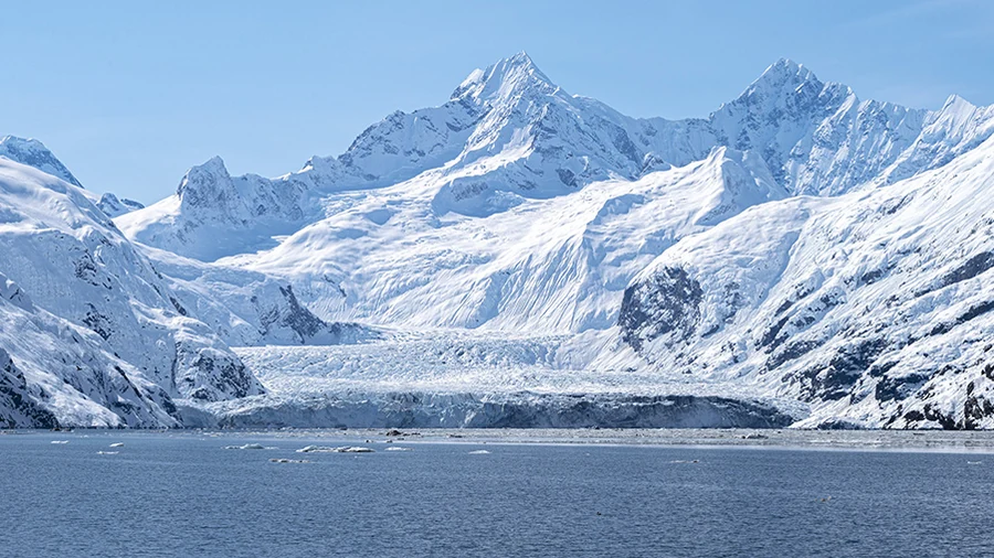
Johns Hopkins Inlet: Johns Hopkins Glacier lies far inside its namesake fjord, beyond the Jaw Point area. Icebergs here are habitat as well as scenery: harbor seals use the floating ice. National Park Service rules close the upper inlet to vessels, including kayaks, from May 1 through June 30 for seal pupping. Rules differ later in the season, and access to the glacier face is not a guaranteed part of either a day boat or a cruise. Check the official cutoff and conditions rather than using the editorial map as a chart.
Why a glacier-front map needs a date
A terminus is the glacier’s lower end. A tidewater glacier reaches seawater and can lose ice by calving, when pieces of its front break away; a glacier that ends altogether on land is different, even if it still looms over a fjord. Lamplugh illustrates the awkward edge case: the park’s selected-glaciers profile describes its front as grounded, with salt water reaching the ice at high tide. Nearby Reid is described as fully grounded. Its inlet still carries the glacier’s name.
Some changes happen across just one ice face. A National Park Service comparison of Landsat and Sentinel images through 2023 found that these two glaciers behaved differently.
| Glacier | Change in the satellite comparison through 2023 | Contact with the inlet |
|---|---|---|
| Margerie, Tarr Inlet | Retreated in recent years after decades of relative stability. | Rangers reported that part of the northern front ended on land. That did not establish that the whole front had lost contact with seawater. |
| Johns Hopkins, Johns Hopkins Inlet | Advanced over the longer term. | The study describes it as a tidewater glacier. That describes where the ice ends, not where a vessel may go. |
A 2026 airborne-survey study still described Margerie as a tidewater viewing case and reported substantial thinning. Neither study shows where every part of an ice face ends today. Use the Glacier Bay map to place the inlets and the park’s current marine information to check access.
Check the road transfer and the boat on separate clocks
The seasonal day boat departs from and returns to Bartlett Cove. The operator describes it as an eight-hour outing and says that 2027 dates are available. Check the calendar for your exact day rather than carrying the 2026 season forward. The park’s November 2026 example route explicitly says weather and ice can change the trip. A marked inlet tells you where it is, not which turns the captain will make. The Park Service describes cruise visits as onboard outings: rangers come aboard rather than passengers disembarking to reach the visitor center. If the ship’s schedule puts you near a glacier around the same time as an indoor activity, check the day’s program first.
If the local road is disrupted, a fly-in or ferry arrival in Gustavus no longer settles how you get to the dock. Conversely, an open local road does not confirm the boat is sailing or that an inlet is accessible. Check park alerts and the Gustavus forecast for the land transfer, then confirm the sailing and any same-day changes with the operator. A cruise passenger already sailing in Glacier Bay has a separate itinerary and does not depend on the Gustavus road for that visit.
Planning information checked November 21, 2026. Check alerts, service dates and marine rules again for your trip.
Frequently Asked Questions
Do I have to stay at Glacier Bay Lodge to take the day boat?
No. The Park Service notes that day-tour passengers typically spend the preceding night either in Gustavus or at the lodge. Staying in town means arranging the early ride to Bartlett Cove. If you are considering arriving by plane the same morning, ask the operator whether it works for your date and make a backup plan for weather disruption.
Can a private boat enter the bay with no permit?
Do not assume so. The park requires a free entry permit for a private motor vessel between June 1 and August 31 and has separate requirements for other kinds of access. Look at its current boating rules before a private trip; a day-boat booking is not a private-vessel permit.
Is there a shore outing if I cannot walk the whole Forest Loop?
Yes. The park describes the gravel path from the public dock parking area toward the Tribal House as a flat option, and part of the public-use dock is paved with a viewing platform. Check current conditions if uneven surfaces, weather or an accessible restroom matter to your visit.
Does the glacier marker show the ice face a boat can see today?
No. The marker names the glacier, the snow and ice layer is from 2021, and the satellite comparison cited here runs through 2023. What a vessel can see on your trip also depends on weather, ice and any access restrictions that apply to that vessel.
What Did We Learn Today?
Use Gustavus and Bartlett Cove to plan the road journey, then treat the upper bay as a separate trip on the water. Margerie and Johns Hopkins sit in different West Arm inlets, and where their ice ends can change. The shore map, a dated glacier observation and a current sailing update answer three different questions.
Sources & Data Notes
The access map uses 2021 land cover and mapped roads, not digitized ice fronts. The comparison uses a separate National Park Service study based on Landsat and Sentinel imagery through 2023, with reported on-the-water observations. Neither is a current navigation or visibility report.
- National Park Service: directions and local road access, trail lengths, Huna Tribal House and accessible paths and dock.
- National Park Service: tour services, cruise visits, private boating and permits, November 2026 example route, 2026 approved day-boat schedule, boating regulations, alerts and weather and live forecast links. The authorized concessioner confirms 2027 booking availability and describes the eight-hour outing. Exact sailings are not assured. Service and rules reviewed November 21, 2026.
- Glacier cases: NPS selected glacier profiles, Gende, Womble and Bliss (2025), terminus comparisons through 2023, and the 2026 airborne-survey study. The dates refer to the cited observations or publications, not a glacier survey on the date this guide was checked.
- Map: GeographyPin, from ESA WorldCover 2021 v200 (CC BY 4.0; © ESA WorldCover project 2021, contains modified Copernicus Sentinel data (2021) processed by the ESA WorldCover consortium), public NPS road data, U.S. Census TIGER/Line 2025 roads, Alaska DOT&PF Gustavus terminal reference, USGS GNIS and NPS maps and NOAA/NPS 2025 chart for name placement. Generalized for reading rather than navigation. The inset is at a larger scale than the bay panel. Glacier names are geographic references, not a delineation of their termini.
- Photograph: Johns Hopkins Glacier by Sean Tevebaugh / National Park Service, public-domain NPS photograph; cropped for display. The source does not give a capture date.