Denali Park Road runs west for 92 miles from Alaska’s Parks Highway. The line on the map is the whole road, not the part you can drive. When we checked on November 21, 2026, private vehicles could reach Park Headquarters at mile 3. For a summer trip, the important numbers are mile 15 for a regular drive and the turnaround mile on your bus ticket.
As checked November 21, 2026, private vehicles could drive from the Parks Highway entrance to Park Headquarters at mile 3. In summer, most drivers can go as far as Savage River at mile 15, conditions permitting. The rest of the 92-mile road is not a regular private-car drive; check which buses run on your date.
How to use this article: See the whole road and winter limit, choose an outing near the entrance, or compare the 2027 bus turnarounds.
Denali Park Road map and access by season
Road mile zero is at the Parks Highway
Take the park entrance at highway mile 237 on the George Parks Highway (Alaska Route 3). From that junction, the park’s mileposts count west toward Kantishna. They do not count from Anchorage, Fairbanks or your hotel. From the entrance, headquarters comes before Mountain Vista and Savage River; East Fork and Pretty Rocks are much farther in.
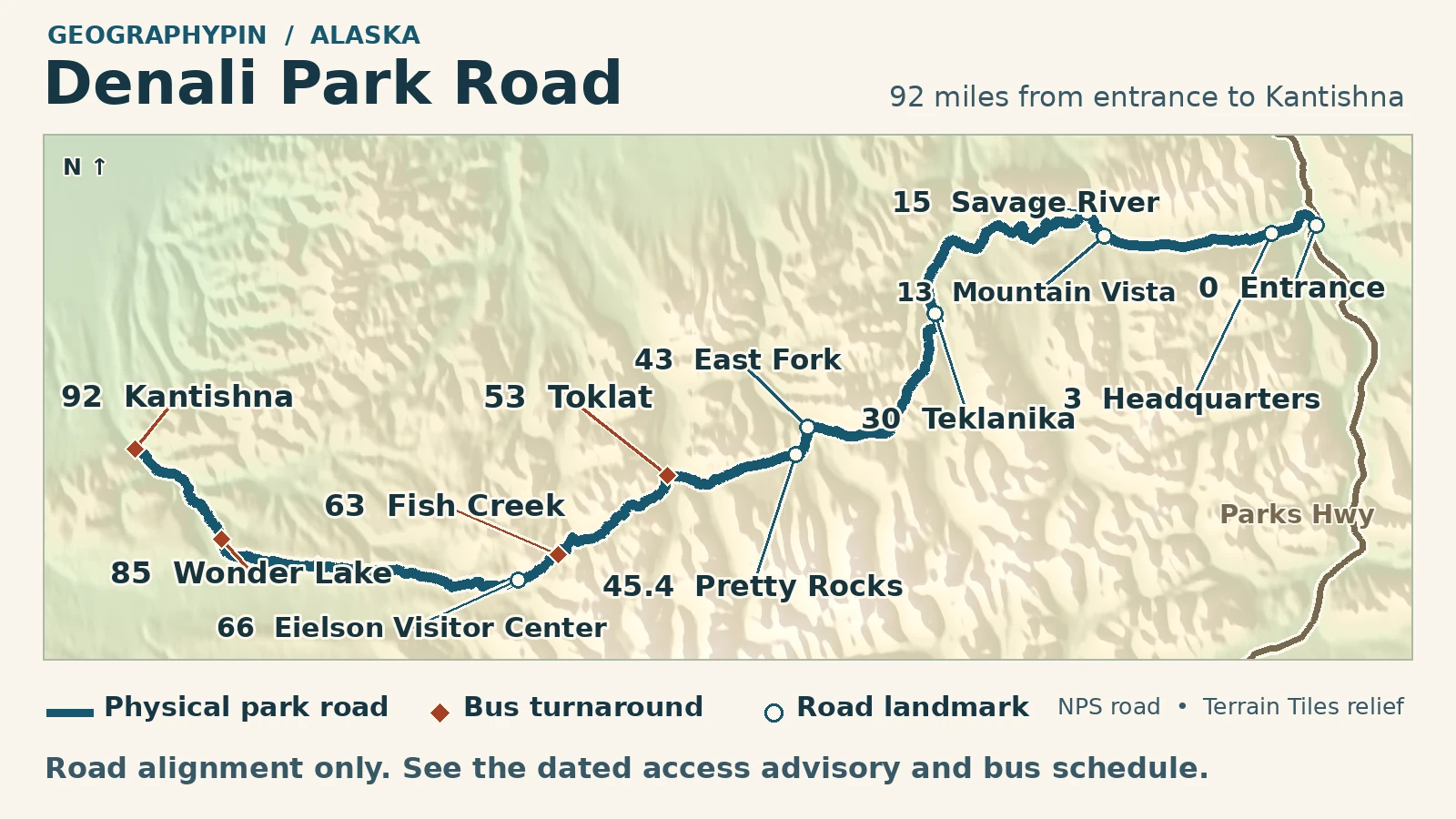
2027 scheduled starts: Toklat (mile 53) on May 20; Fish Creek (63) on June 1; Wonder Lake (85) and Kantishna (92) on June 8. All four are listed through September 16. See the turnaround table for trip lengths and booking details.
| Trip | Road limit | What to check |
|---|---|---|
| Winter drive, checked Nov. 21, 2026 | Headquarters, mile 3 | NPS road conditions and any new closure. |
| Regular summer drive | Savage River, mile 15 | Conditions and limited trailhead parking; a free summer shuttle also serves this area. |
| Summer 2027 ticketed transit | Turnarounds at miles 53, 63, 85 or 92 | Different starting dates and round-trip lengths; see the schedule below. |
Winter road check, November 21, 2026: The NPS road status showed only the entrance-to-headquarters stretch open to vehicles. Check the National Park Service’s current conditions before relying on that limit. NPS typically plows through to Mountain Vista around mid-February, but that is not a fixed date or a promise for 2027.
What to do on the eastern road
Choose Mountain Vista or Savage River
Start near the entrance in winter. The Murie Science and Learning Center serves as the winter visitor center. Check its hours and ask what is accessible that day rather than counting on reaching a trailhead west of headquarters.
When the road and trails are open, Mountain Vista at about mile 13 has a 0.6-mile loop. The shuttle stop gets you to the trailhead; the mountain view is along the walk and depends on the weather. Another two road miles take you to Savage River, where a separate two-mile walking loop follows the river. Those are walking distances, not more miles to drive. If Savage River parking is tight, consider the free summer shuttle rather than booking a bus into the interior. NPS lists the free Savage River service for May 15 through September 20, 2027, with shorter hours at either end of the season. That makes a short shuttle ride an option on some dates before the first scheduled Toklat trip.
What changed west of East Fork
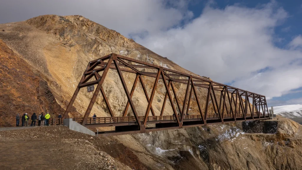
In summer 2026, buses turned at East Fork, roughly mile 43. The trouble spot was still farther west: the road crossed an active landslide near mile 45.4 at Pretty Rocks. The new bridge spans the slide rather than trying to hold the old road surface in place. NPS announced bridge completion in September 2026, but did not extend that summer’s bus service past East Fork. Hikers and cyclists had been allowed to cross the bridge from August 27; that change did not open the road to regular cars.
You may also see an older alert about driving to Teklanika River, mile 30. That fall 2026 arrangement began September 18 after bus season and depended on weather. It was neither the normal summer driving limit nor the November winter limit.
Choosing a 2027 transit bus
The farthest turnaround depends on the date
The park and Reserve Denali list December 1, 2026, as the opening date for 2027 bus and campground reservations. The operator’s published transit plan starts in stages, so a late-May trip does not have the same options as a June trip.
| Turnaround | Miles from entrance | Scheduled dates | Approx. round trip |
|---|---|---|---|
| Toklat | 53 | May 20 to September 16 | 6½ hours |
| Fish Creek | 63 | June 1 to September 16 | 8 hours |
| Wonder Lake | 85 | June 8 to September 16 | 11 hours |
| Kantishna | 92 | June 8 to September 16 | 12 hours |
Do not plan around Eielson. The visitor center at mile 66 is set to close for up to two years for roof replacement, and the operator does not offer an Eielson turnaround in 2027. If you just want to ride beyond Pretty Rocks, Toklat is the first scheduled turnaround west of the bridge. Choosing Kantishna instead turns a 6½-hour outing into a roughly 12-hour one. Toklat is scheduled to start before Fish Creek. Match your travel date to the turnaround before buying a ticket.
Transit buses board at the Denali Bus Depot near mile 0.5, not at area hotels. The operator asks passengers to arrive at least 20 minutes early. Bring food and water; the bus operator says neither is sold once the trip is underway.
If you get off a transit bus to hike, NPS says you can reboard only if there is an available seat. Leave room in your plan to wait for another bus; getting off does not reserve a seat on a later departure.
Frequently Asked Questions
Does a Denali transit ticket include entrance to the park?
No. The transit fare is separate from the NPS entrance fee. Bring your valid park pass or proof of entrance payment if you already have one, and check which pass applies to your group.
How do I book a bus that can carry my wheelchair?
Reserve Denali lists wheelchair-equipped buses at designated times, with one wheelchair space per designated transit bus. Call the operator before choosing a departure and tell the agent what you need rather than assuming any departure can accommodate it.
Is the Denali railroad station the same as the bus depot?
No. The Alaska Railroad stop is near the summer Denali Visitor Center, while interior transit buses leave from the Denali Bus Depot. See the NPS arrival guidance and leave time to reach the correct building.
Is Fish Creek the same stop as Eielson Visitor Center?
No. Fish Creek is the mile 63 turnaround for the eight-hour service in the published June 1–September 16, 2027 schedule. The visitor center is farther west at mile 66, and the operator lists no Eielson turnaround in 2027. NPS also says Fish Creek has no visitor services or facilities.
What Did We Learn Today?
Denali Park Road has a fixed mile zero, but no year-round turnaround for visitors. Check the park’s road limit for a drive; for a bus, choose by the first operating date, the turnaround and the time it takes to come back. A line through to Kantishna alone tells you none of those things.
Sources & Data Notes
Open the road status, transit schedule, map sources and photo credit
Road status and the published 2027 transit plan were checked November 21, 2026. The winter designation applies to vehicle access, not to trails or other activities. Close-to-entrance mileage uses the park’s rounded visitor mileposts; the map’s mile-85 marker indicates the park road in the vicinity of the lake.
- NPS current conditions, updated November 18, 2026; winter visitor information; park trail distances map.
- Reserve Denali reservation opening notice and 2027 transit schedule and boarding information. Dates and durations are published plans, not a seat or departure confirmation.
- NPS bridge completion, FHWA Polychrome project geography, and NPS dated fall 2026 opening.
Map artwork: GeographyPin. Both map layouts use actual NPS road segment data and the park GIS roads download. Relief: Mapzen Terrain Tiles accessed November 21, 2026. Terrain credits include U.S. Geological Survey elevation, NOAA ETOPO1 and ArcticDEM DEMs made from DigitalGlobe imagery and funded under NSF awards 1043681, 1559691 and 1542736. The bridge marker is approximate. Fish Creek is located approximately by interpolating mile 63 along the NPS measured Toklat–Eielson road segment (mile 53.4 to 65.9), not by surveying a boarding bay. Neither map is an engineering survey or a navigation map.
Photograph: the completed Pretty Rocks bridge, September 2, 2026, NPS Photo, U.S. federal public domain. Cropped, resized and converted to WebP.