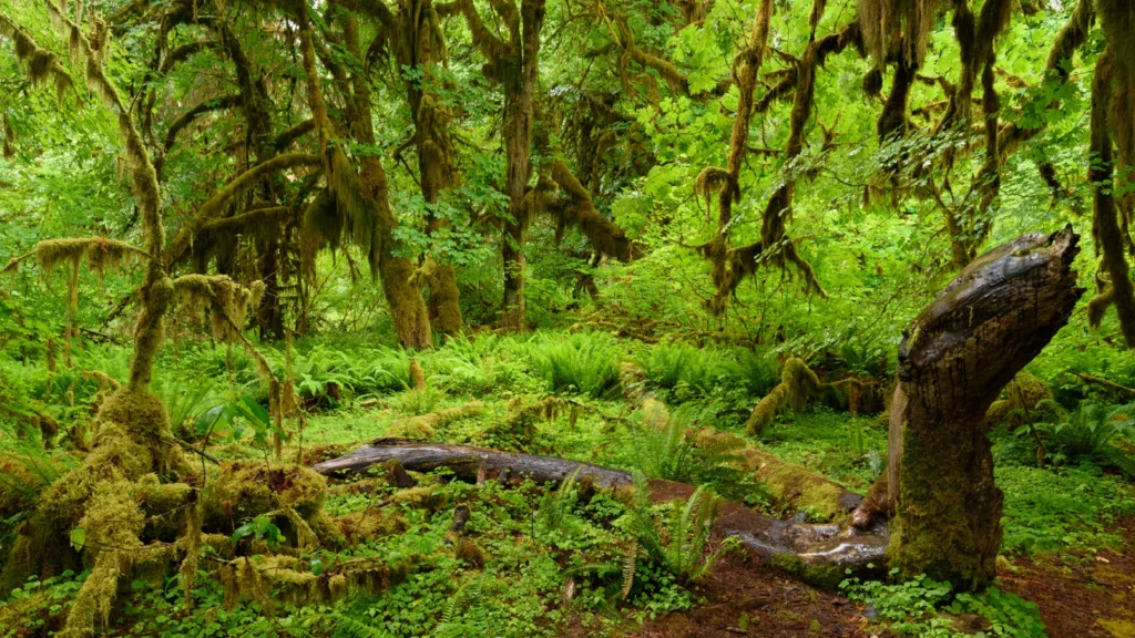
An Olympic National Park itinerary starts with the roads, not the distance between dots on a map. The mountain ridge, rain forest and Pacific beaches each have their own approach. A change at one entrance can leave the rest of your trip intact.
Plan Olympic around separate access roads
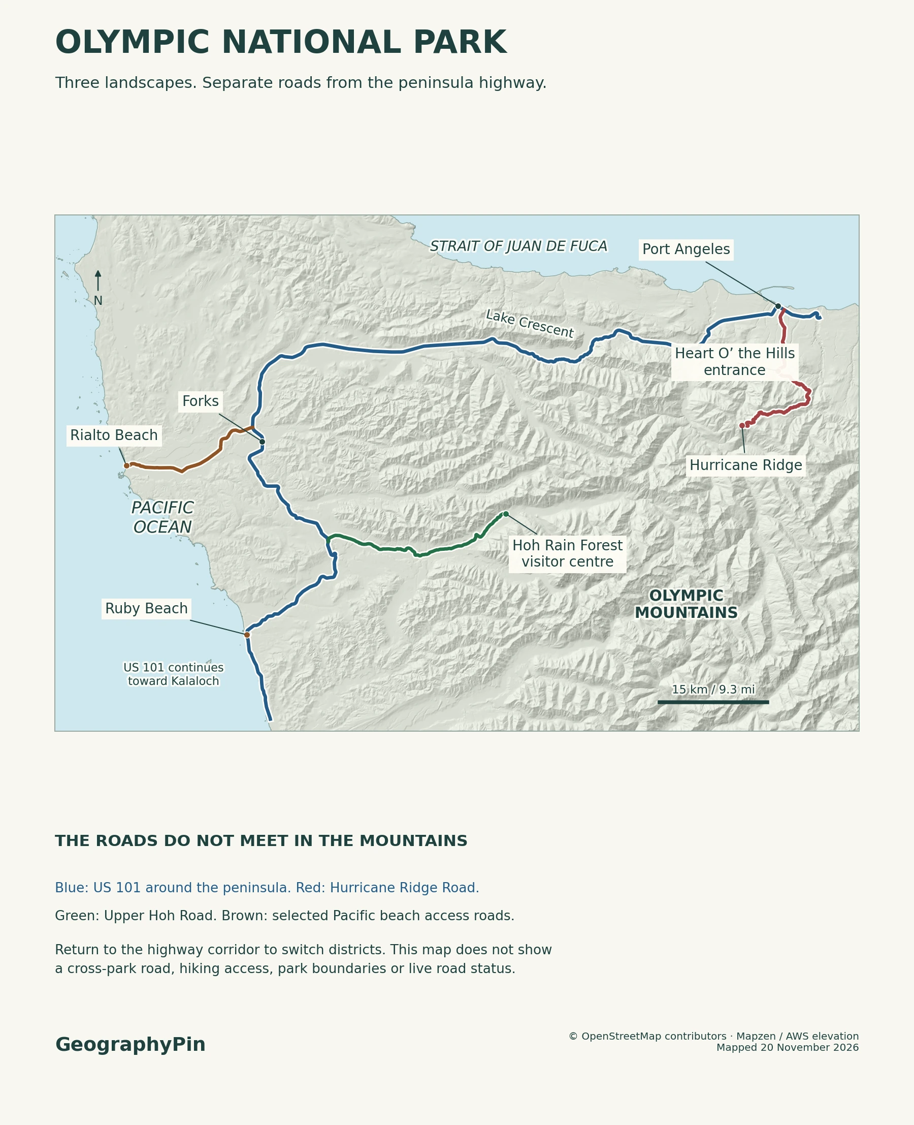
Use U.S. 101 around Washington’s Olympic Peninsula. Drive to Hurricane Ridge from Port Angeles, take Upper Hoh Road to the rain forest, and use separate roads or turnoffs for Pacific beaches. No road cuts through the park’s mountainous interior, so split the ridge and the western districts across different days when possible.
How to use this article: Choose a one-day or two-day plan, compare the two Pacific beach approaches, or check which agency to consult for a closure.
Choose a district before planning the drive
On the north side, use Port Angeles as the reference for Hurricane Ridge. On the west side, Forks is a useful base for the Hoh Rain Forest and nearby Pacific beaches. Both are on or by U.S. 101; neither is a universal entrance station for all three landscapes.
Plan one day in one area or split two days by geography
| Your time | Where to focus | What changes the plan |
|---|---|---|
| One day | From Port Angeles, pick the ridge if it is open; from Forks, pick the Hoh and one coast stop if daylight and conditions allow. | Skip the cross-peninsula dash. If the first stop slips, keep only one main destination. |
| Two days | Use one day for Hurricane Ridge and the north side, another for the Hoh and either Rialto or Ruby Beach. | Move the coast stop around the tide, then check the mountain road separately. |
The National Park Service’s driving table puts Hurricane Ridge Ranger Station to the Hoh Rain Forest Visitor Center at 106 miles (171 km). That estimate runs back down to the highway and around the mountains, not over a ridge into the next valley. Allow for that drive before trying to fit both stops into one day.
Hurricane Ridge from Port Angeles
From Port Angeles, take Hurricane Ridge Road via the Heart O’ the Hills entrance station. NPS puts the paved approach to the main ridge area at 17 miles (27 km). Much of that drive climbs, ending in the subalpine landscape above the wooded slopes. This road has no onward vehicle connection to the Hoh.
The main ridge parking area and Hurricane Hill Road beyond it are different access points. The short extension serves the Hurricane Hill trailhead and picnic areas when open. A closure on that extension does not necessarily block the drive to the main ridge lot; a closure on the main approach does. Check which segment the park names.
The former Hurricane Ridge Day Lodge burned in 2023. Do not count on an older map’s visitor center label for drinking water or indoor services. For the 2026–27 winter plan, NPS announced a November 28, 2026 start for winter operations, weather permitting, and says all vehicles must carry tire chains or approved alternatives during the winter season, including four-wheel drive. Verify the current gate and traction rules before driving up.
The Hoh Rain Forest road and trails
South of Forks, turn from U.S. 101 onto Upper Hoh Road. The paved road runs about 18 miles (29 km) from the highway to the park’s Hoh Rain Forest area. It follows the river valley inland and stops at the developed area and trailheads. Do not look for an onward drive to the north or a second road into the same parking area.
Hall of Mosses is a 0.8-mile (1.3-km) loop from near the visitor center. The Spruce Nature Trail adds a different 1.2-mile (1.9-km) loop beside the river. Those are individual walks, not a continuation of the approach drive. In busy periods, an entrance wait can matter more than the walk length.
The road, parking and trails can be open when the staffed Hoh Rain Forest Visitor Center is closed. Treat the center as a useful name for the destination, not a promise that you can get a printed map or speak to a ranger there.
Pacific beach access at Rialto and Ruby
Rialto via Mora Road, Ruby from U.S. 101
For Rialto Beach, take Washington 110 toward La Push, then turn onto Mora Road. NPS places Rialto about 5 miles (8 km) from the Washington 110 junction. The beach is north of the Quillayute River mouth. Continuing to La Push instead takes you to the other side of the river, not into the Rialto parking lot.
For Ruby Beach, stay on U.S. 101 toward the Kalaloch area and use the signed beach turnoff. The beach below the lot is a short downhill walk. Rialto’s walk to Hole-in-the-Wall, by contrast, is about 1.5 miles (2.4 km) one way north from the trailhead, much of it along the beach. That number is not a road distance or a guarantee the arch is reachable.
Check NPS tide and surf guidance and the local marine forecast before walking beyond the access area. A low-tide prediction is one input, not proof that you can pass. Rough surf and rising water can cut off the return near headlands. Turn back if the beach route is not safe.
What closures change on the itinerary
Check the spur road and the highway that connects it
Before leaving, check both the NPS road table and its district alerts. Phone the recorded road and weather line at 360-565-3131 when information differs. Use Washington State Department of Transportation for U.S. 101 itself. A closure on the highway can disrupt the link between districts even when a park spur is open.
Checked November 20, 2026: the NPS district page reported Hurricane Ridge Road closed for ice and rockfall. It listed the Hoh rain forest area open, with the visitor center closed for November. For Mora Road, an open entry dated November 16 remained in the NPS road table while the November 17 district page said storm damage had closed it. Do not count on Rialto access from those conflicting entries; check the latest recording before driving out.
If the ridge is closed, reconsider the mountain portion rather than looking for a substitute road across the park. If the Upper Hoh Road is closed, the Hoh trailheads drop off the driving plan. If Mora Road is closed, that affects Rialto; Ruby uses a different turnoff. Check the highway and tides before substituting it.
Frequently Asked Questions
Can I bring a dog from the Rialto parking lot all the way to Hole-in-the-Wall?
No. NPS limits leashed dogs on Rialto to the stretch from the parking lot north to Ellen Creek, during daylight. That does not extend to Hole-in-the-Wall. The park lists different pet rules for its Kalaloch beaches; check the rules for the exact beach you choose.
Does a day visit need the same permit as camping on the wilderness coast?
No. NPS requires a wilderness permit obtained in advance for an overnight wilderness stay. Choosing a day-use beach stop is a different plan, and a campground reservation does not replace a wilderness permit for a backcountry overnight.
Can I use the official park map without a signal?
Yes. Download Olympic in the official NPS app before losing service. For a beach hike, also carry the detailed topographic information and current tide table NPS recommends. An offline road map is not a tide table or a current closure notice.
What Did We Learn Today?
U.S. 101 connects separate trips into Olympic National Park, not a drive across its center. Start the ridge trip from Port Angeles, use Upper Hoh Road for the forest, and choose the coast stop by its own road and tide conditions. A closure changes the leg it affects, not automatically every district.
Sources & Data Notes
The official park brochure and map and NPS point-to-point driving table distinguish the access roads. Use the NPS road table, park district alerts and WSDOT highway reports for changing conditions. Hurricane Ridge approach, winter operations and traction requirements and post-fire ridge services document the mountain approach and its facilities; see the Hoh Rain Forest trail brochure, NPS day-hike approaches and NPS tide and surf guidance for walk distances and coast planning. The NPS pet rules, NPS wilderness coast guidance and permits, NPS app offline map instructions and Rialto Beach site rules cover the follow-up questions. Distances are rounded in metric units; the atlas is a road locator, not a tidal or wilderness trail map. Hall of Mosses photograph: King of Hearts (CC BY-SA 4.0), cropped and converted to WebP under the same license. Editorial responsibility: Zurab Koniashvili (Z.K. Atlas); AI tools assisted in preparation.

Map: GeographyPin; coast and road geometry from OpenStreetMap contributors (ODbL) and relief from Mapzen/AWS. The map does not show current road access, tide conditions or a park boundary.