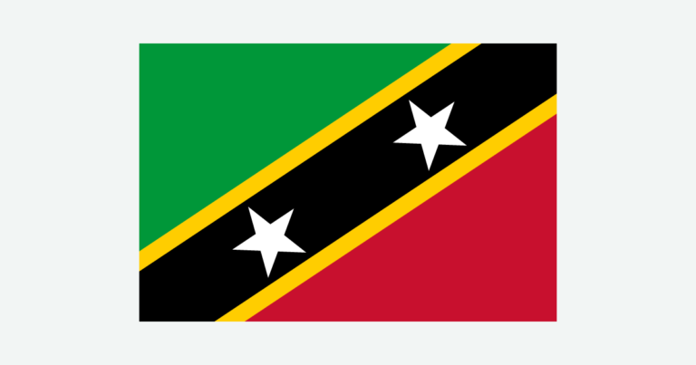
Saint Kitts and Nevis is one federation with two distinct island landscapes. Saint Kitts stretches from volcanic highlands to a narrow southeastern peninsula, while smaller Nevis rises around its central peak. The short sea crossing between them connects communities with different administrative centers, water systems and development priorities.
Saint Kitts and Nevis is a Caribbean federation formed by two main islands in the Lesser Antilles. Basseterre, on Saint Kitts, is the national capital; Charlestown is the administrative center of Nevis. The islands are separated by the Narrows. Volcanic highlands, coastal settlement and differences in rainfall shape their geography, but Nevis is not a separate sovereign country.
How to use this article: Clarify the federation’s island geography, read the physical map, explore water supplies, or check the population reference.
1. Locate the Two Islands and Define the Federation
Two islands within one federation
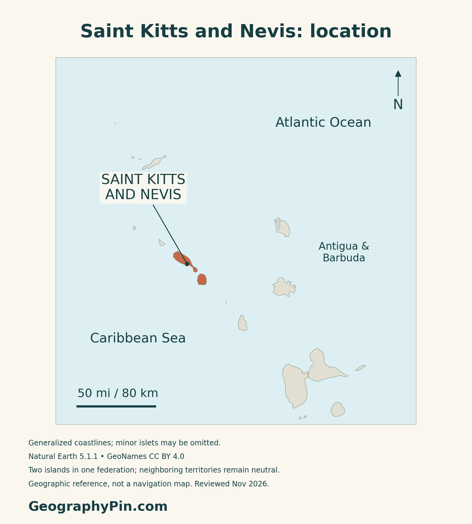
Saint Kitts and Nevis is one sovereign country in the eastern Caribbean, not two independent states. Its two main islands are Saint Kitts, also called Saint Christopher, and Nevis. They belong to the Lesser Antilles, with Nevis lying southeast of Saint Kitts.
Basseterre and Charlestown have different roles
Basseterre, on Saint Kitts, is the federal capital and the location of the national government headquarters. Charlestown is Nevis’s administrative centre. The two towns help explain the federation’s organization: national institutions serve both islands, while Nevis also has its own island administration.
The Caribbean countries and territories map places the federation among its island neighbors.
2. Volcanic Landscapes and the Physical Map
Compare Saint Kitts with Nevis
| Place | Physical setting | Main distinction |
|---|---|---|
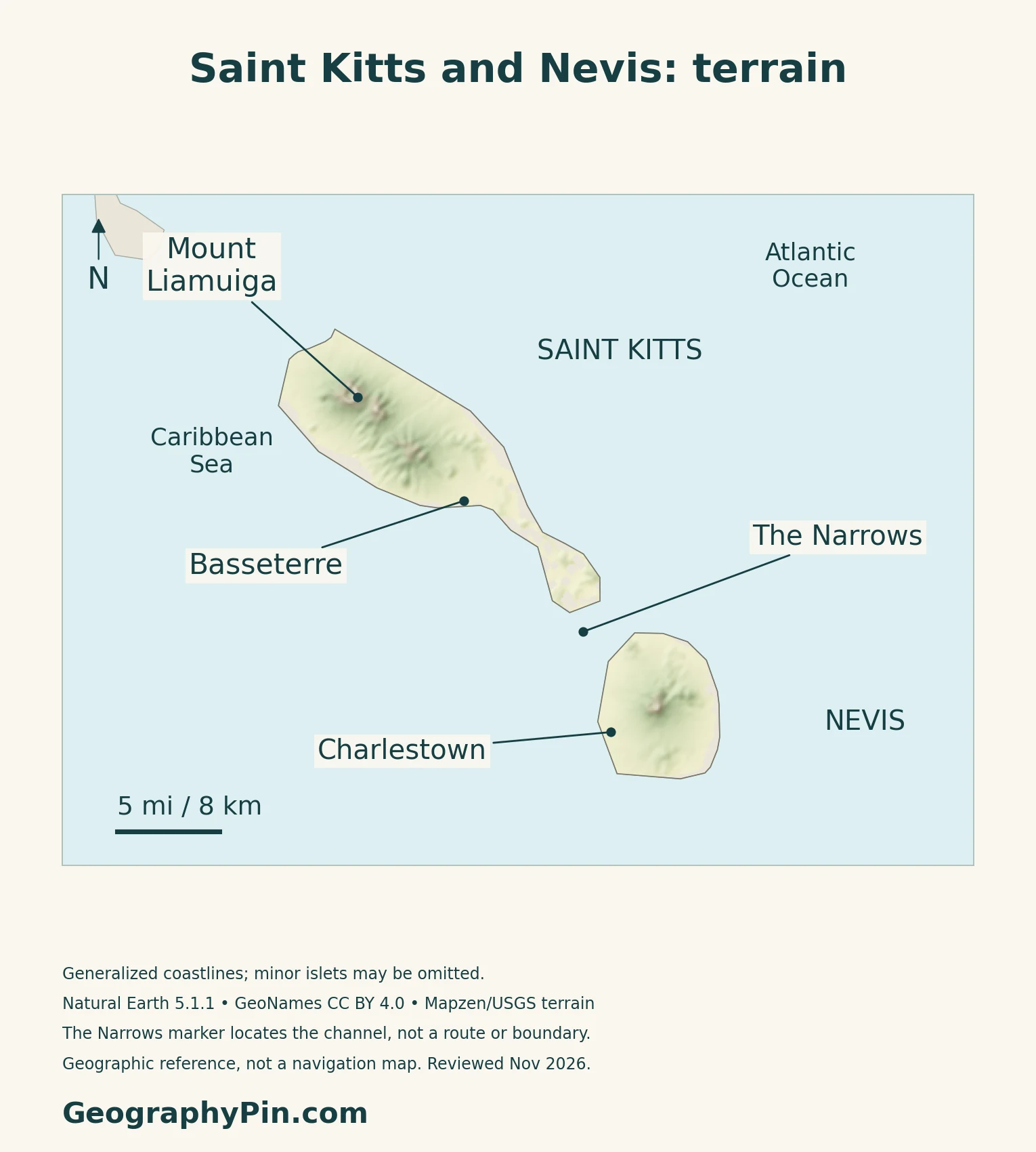
| Saint Kitts | Elongated island with several volcanic centers and a southeastern peninsula | Basseterre is the federal capital |
| Nevis | Smaller island dominated by Nevis Peak and associated volcanic landforms | Charlestown serves the island administration |
| The Narrows | Sea channel between the two islands | Separates islands, not independent states |
The islands are not just two identical cones
The UWI Seismic Research Centre identifies several volcanic centers on Saint Kitts, including Mount Liamuiga, the Middle Range, the South East Range and the Salt Pond Peninsula. Their differing histories help explain why the island combines high mountains with lower, narrower land to the southeast.
Nevis Peak dominates the smaller island, but its landscape also includes older volcanic centers and lava-dome remnants. UWI describes flank deposits extending outward from the main center toward the sea.
A narrow peninsula faces Nevis
Saint Kitts narrows toward its southeastern end, where the Great Salt Pond lies. Beyond the peninsula, the Narrows separates it from Nevis. UNCTAD’s geographic profile describes the channel as about 2 miles (3 kilometers) wide; that is an orientation figure, not a ferry-route distance.
3. Rainfall, Catchments and Changing Water Supplies
Coasts and mountain interiors receive different rainfall
The national Agricultural Transformation and Growth Strategy 2022–2031 describes a tropical marine climate influenced by the northeast trade winds. Rainfall on Saint Kitts increases strongly with altitude, while Nevis is generally drier in the strategy’s climatic overview.
The Department of Statistics also publishes separate annual rainfall series for the two islands. Those annual totals vary from year to year, and the published table does not identify the station coverage needed to treat them as full-island spatial averages. A single year’s ranking should therefore not replace the longer-term description of mountain and coastal contrasts.
Rain-fed sources and desalination play different roles
The government’s 2023 Voluntary National Review described Saint Kitts as drawing water from streams, springs and wells, while Nevis relied largely on groundwater wells. The same review identified storage limitations, aging distribution infrastructure and leakage as challenges alongside the amount of rainfall available.
That baseline has since changed. The Basseterre Desalination Plant was commissioned in February 2026, adding seawater desalination to the public supply. An infrastructure-ministry update dated October 15, 2026 confirmed that it was back in operation after pipeline repairs.
Desalination diversifies the source of supply, while the dated repair notice illustrates that treatment equipment, storage and distribution still matter.
4. Coastal Settlement, Land Use and Energy
Sugar shaped an industrial landscape, not just a crop
Saint Kitts’ National Archives records the development of a central sugar factory, railway and associated infrastructure in the early twentieth century. The factory officially opened in 1912, concentrating processing that had previously been spread across estates.
The industry closed in July 2005. Its former infrastructure is evidence of an earlier economic system, not proof that sugar remains the country’s dominant export today. The history helps explain why land use and transport networks cannot be read from the present tourism economy alone.
Brimstone Hill links topography and built heritage
Brimstone Hill Fortress occupies a steep, double-peaked volcanic hill on Saint Kitts. Its British military designers used the elevation to defend the coastline, and enslaved Africans built the fortress. UNESCO describes basalt masonry and locally obtained limestone among its construction materials.
The property was inscribed on the World Heritage List in 1999. Here, relief and local rock were directly incorporated into a human-built landscape rather than merely forming its backdrop.
Geothermal potential is not the same as electricity production
Nevis’ volcanic setting has prompted geothermal-energy development, but project stages need dates. In its November 10, 2026 update, the Nevis Island Administration reported civil works at Hamilton ahead of the drilling rig’s arrival. A production plant and inter-island electricity connection remained matters for subsequent development and financing.
That account does not establish that geothermal electricity was already being generated for the federation. The distinction is important when reading older announcements or proposed capacity figures.
Water, transport and tourism connect the islands to wider markets
The IMF’s May 2026 consultation identified tourism, construction, agriculture and renewable-energy projects among the economy’s important activities, while noting exposure to external energy costs. Those connections make transport and utility infrastructure central to economic geography.
The 2023 national review also identifies low-lying coastal development as exposed to sea-level rise and storm-related damage. This does not make every part of either island equally exposed. The separate Caribbean hurricane-risk guide provides the wider regional context.
5. Country Facts, Census Scope and Nevis Administration
| Item | Reference | Date or scope |
|---|---|---|
| Federal capital | Basseterre | On Saint Kitts; Charlestown is Nevis’s administrative centre |
| Population reference | 51,320 | 2022 census usual residents in private households; 18 April 2022 |
| Surface area | About 101 sq mi (261 km²) | UN reference, 2023; not maritime jurisdiction |
| Language | English | Designated official on the government country profile |
| Currency | East Caribbean dollar (XCD) | Shared regional currency |
| Government | Federal constitutional monarchy | One sovereign state with a separate Nevis Island Administration |
| Parishes | Fourteen | Nine on Saint Kitts and five on Nevis in the census geography |
What the census population covers
The Department of Statistics’ 2022 census highlights report counts usual residents in private households. It includes household members temporarily away but excludes institutional and collective accommodation, short-stay establishments and temporary visitors. The figure is therefore a specifically defined census population, not a current headcount of everyone present in the federation.
Within that same census scope, Saint Kitts had 38,138 residents and Nevis had 13,182. These island totals should not be mistaken for the populations of Basseterre and Charlestown.
Nevis’s constitutional administration
The Constitution provides Nevis with an Island Assembly and an Island Administration headed by a premier. Its defined responsibilities include education, health, fisheries and ports, within constitutional limits and the wider federal framework. This arrangement gives Nevis a distinct governmental role without making it a separate sovereign country.
What Did We Learn Today?
Saint Kitts and Nevis is one federation, with Basseterre as its national capital and a distinct island administration on Nevis. Its two volcanic landscapes differ in shape and water resources. Historic sugar infrastructure, coastal settlement and new utility projects show how the physical setting interacts with changing economic uses; census and project figures need their dates and scope.
Sources & Data Notes
The population reference counts usual residents in private households in the April 18, 2022 census, not everyone present or a current estimate. Surface area follows the UN’s 2023 reference. The 2023 water-supply baseline is supplemented by an October 2026 desalination update. The November 2026 geothermal report describes preparatory works, not an operating power plant. Annual rainfall series are not treated as complete spatial averages.
- Department of Statistics: 2022 census highlights and technical notes
- UNData: Saint Kitts and Nevis reference profile
- Government: country profile
- Constitution: federal state and Nevis administration
- Nevis Island Administration: island government
- UWI Seismic Research Centre: Saint Kitts volcanic centers
- UWI Seismic Research Centre: Nevis volcanic centers
- UNCTAD 2021: island geography
- Agricultural Transformation and Growth Strategy 2022–2031
- Department of Statistics: annual rainfall series
- Government: Voluntary National Review 2023
- Infrastructure Ministry: desalination update, October 15, 2026
- National Archives: the sugar factory
- UNESCO: Brimstone Hill Fortress National Park
- Nevis Island Administration: geothermal project update, November 10, 2026
- IMF: 2026 Article IV consultation
Map method: Original GeographyPin maps use Natural Earth 1:10m countries version 5.1.1, public domain. Both principal islands are retained in their geographic positions; small islets may be omitted at this scale. Neighboring territories remain distinct, and no maritime boundary is inferred. Reference locations use GeoNames under CC BY 4.0. The Narrows marker locates the channel, not a navigation route or an internal boundary; mountain markers do not define landform extents. Shaded relief uses actual Mapzen Terrain Tiles with USGS and upstream attribution. Negative elevation samples and a small buffer are omitted to avoid coastal artifacts, not replaced with invented heights. Raster values are not summit measurements. WGS84 geodesic scale bars are calculated at their displayed latitude. Review date: November 2026, not a coastline or terrain survey date. The cover combines the geographic outline with an intact national flag for editorial identification; the Wikimedia Commons flag rendition is marked public domain as simple geometry.