Cuba’s long main island is familiar on a Caribbean map, but it is only part of the country. Limestone valleys, broad plains and eastern mountains share that island, while Isla de la Juventud and numerous smaller islands extend the national geography offshore. Understanding those different landscapes explains why Cuba cannot be reduced to beaches, Havana or a single mountain range.
Cuba is an archipelago, not just one island. The country includes the large island of Cuba, Isla de la Juventud and thousands of smaller islands and cays. The main island contains most of the country’s land and its capital, Havana; the surrounding islands belong to the same country but have distinct landscapes and settlement patterns.
How to use this article: Distinguish the island from the country, explore Viñales karst, or compare the Cauto plain and wetlands.
1. Where Is Cuba?
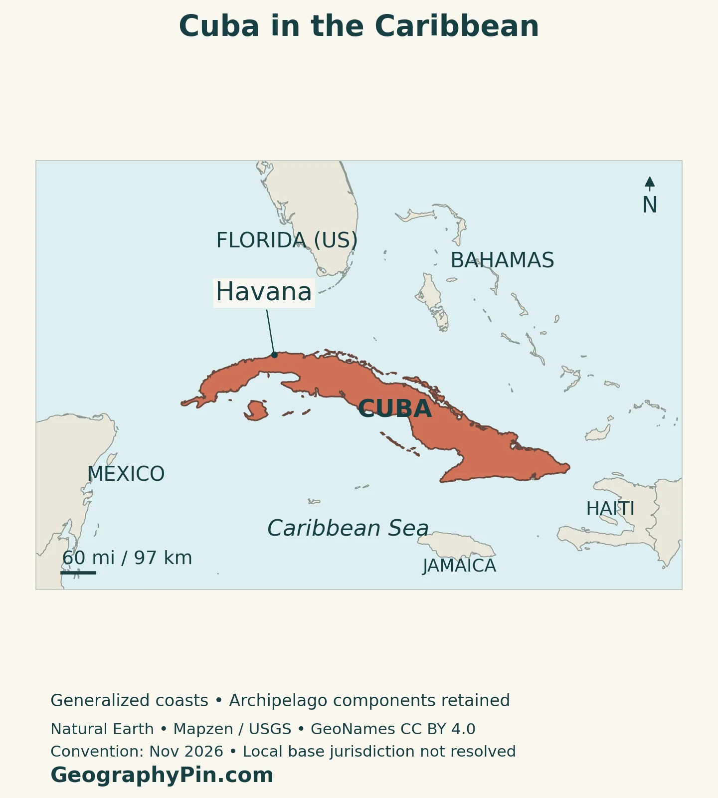
Cuba lies in the northern Caribbean, within the Greater Antilles. Florida is across the Florida Straits to the north, the Yucatán Peninsula lies to the west, and Hispaniola is to the east across the Windward Passage. Jamaica is south of the main island. These are regional neighbors across water, not countries joined to Cuba by an ordinary mainland land border.
The northwestern position of the archipelago places it near the meeting of the Gulf of Mexico, Atlantic waters and the Caribbean Sea. A regional map therefore explains more than an isolated country outline: it shows the sea passages that separate Cuba from nearby land and connect the surrounding basin.
At Guantánamo Bay in southeastern Cuba, the United States operates a naval base under a lease arrangement. The U.S. Army Corps of Engineers describes U.S. jurisdiction there alongside continuing Cuban sovereignty. The regional maps do not delineate that local base-control boundary.
The Main Island and the Country Are Not Identical
The name Cuba can mean either the main island or the Republic of Cuba. Isla de la Juventud, southwest of the main island, is the archipelago’s second-largest island. It belongs to the Canarreos island group and has special-municipality status. Smaller cays also form part of the country; they are not automatically separate territories merely because water separates them from the main island.
Our Caribbean countries and territories map distinguishes independent states from dependencies across the region. Cuba belongs in the independent-country category, while the islands within its archipelago are components of that state.
2. Country Facts with Dates and Scope
| Fact | Detail |
|---|---|
| Capital | Havana (La Habana) |
| Population | 9,434,593 at the end of 2025; ONEI effective-population estimate, not a new census |
| Surface area | About 42,426 square miles (109,884 km²); UNData reference year 2023, not land-only |
| Official language | Spanish, under Article 2 of the 2019 Constitution |
| Currency | Cuban peso (CUP) |
| Government | Socialist republic; president as head of state and prime minister as head of government |
| Administration | 15 provinces and the special municipality of Isla de la Juventud |
| Highest point | Pico Real del Turquino, about 6,476 feet (1,974 meters) |
ONEI’s effective-population measure includes births and accounts for deaths and migration. Its published explanation applies a residence test of at least 180 days in the preceding 365 days, with provision for births during the calendar year. It is not a count of everyone who holds Cuban nationality wherever they live.
This distinction matters when comparing figures. UNData also publishes a separate 2025 medium-variant projection of approximately 10.937 million. That model-based series and ONEI’s end-of-year effective-population estimate use different methods and reference points; they should not be combined into a single population trend without reconciling those differences.
3. Plains, Karst and Mountain Ranges
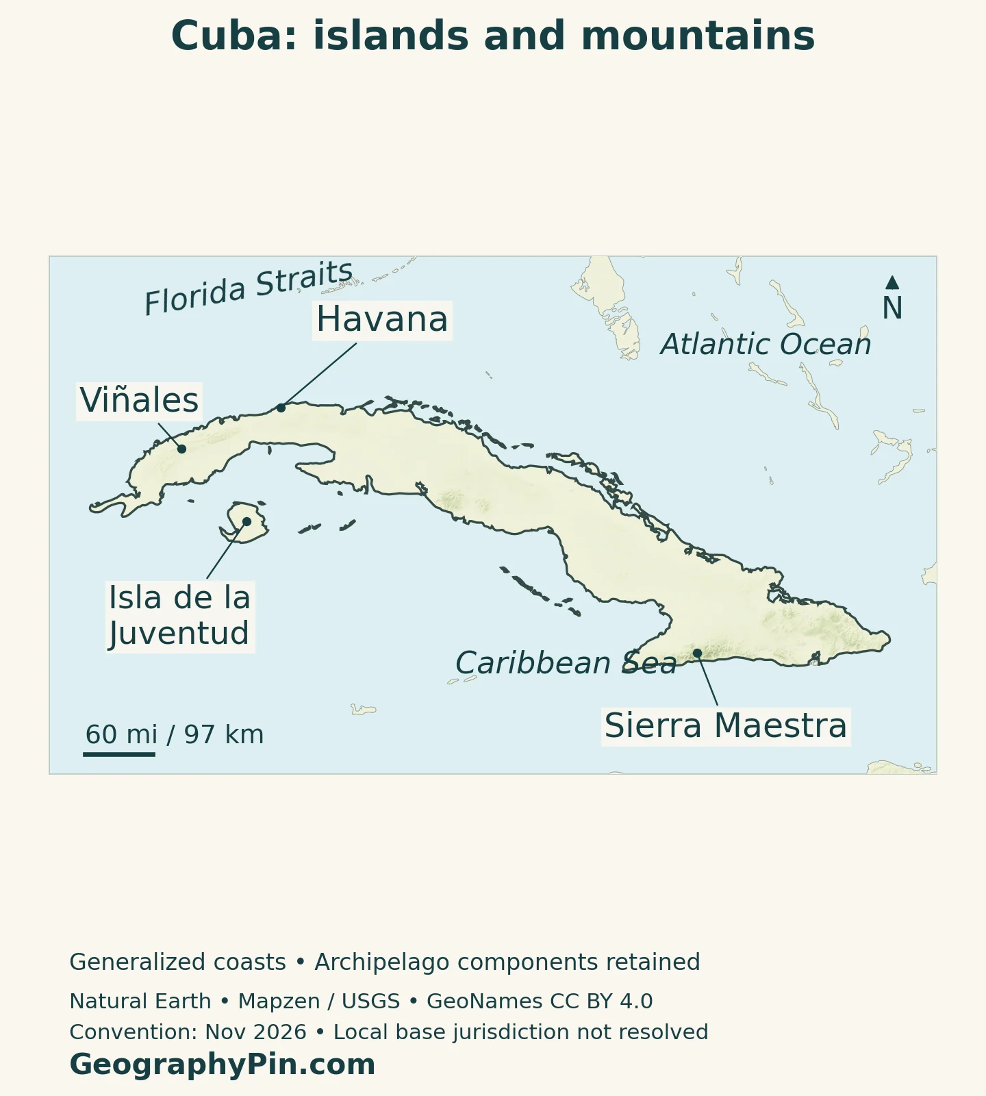
Plains dominate much of Cuba, but several separated mountain systems give the main island a varied relief. Guaniguanico lies in the west, Guamuhaya or Escambray in the central part, and the Sierra Maestra rises in the southeast. The Nipe–Sagua–Baracoa mountains form another important eastern setting. These ranges do not create one uninterrupted spine along the entire island.
| Setting | What distinguishes it | Geographic connection |
|---|---|---|
| Western karst around Viñales | Limestone hills and valley floors | Rock structure, underground drainage and farming |
| Central plains and Guamuhaya | Lowlands interrupted by a mountain massif | Contrasting slopes and agricultural landscapes |
| Sierra Maestra and southeastern Cuba | The country’s highest mountain terrain | Headwaters and the neighboring Cauto plain |
| Northeastern mountains | Varied rocks and forested uplands | Distinctive habitats in the Nipe–Sagua–Baracoa area |
| Isla de la Juventud and offshore cays | Separate islands with varied relief and shorelines | Sea crossings and local coastal environments |
Why Viñales Has Rounded Limestone Hills
Viñales Valley, within the Sierra de los Órganos in western Cuba, is a karst landscape: water has shaped soluble limestone over long periods. Its steep-sided, rounded hills are known as mogotes. They rise abruptly above the valley floor, so the landscape combines relatively level cultivated ground with striking rocky relief.
UNESCO recognizes Viñales as a cultural landscape, not simply a collection of unusual hills. Tobacco cultivation, traditional agricultural practices, farms and village architecture are part of its significance. The relationship between the valley floor and the surrounding limestone is visible in both land use and scenery.
That western landscape should not be used as a model for all Cuban mountains. The forested northeastern ranges have different rocks, soils and ecological histories, while the Sierra Maestra contains the country’s highest ground. Naming the range is more informative than treating every elevated area as the same environment.
4. Water, Wetlands and the Wider Archipelago
The elongated main island gives many rivers relatively short routes to the sea. FAO’s physical-geography account also identifies groundwater in karst areas as important for domestic and agricultural supply. A map showing only surface rivers therefore leaves out part of the freshwater system.
The Cauto Plain and Coastal Wetlands
In eastern Cuba, the Cauto is the country’s longest river. The landscape of Granma places the broad Cauto plain beside the Sierra Maestra, making the contrast between mountain catchments and lower ground especially clear. Rivers descending from the range connect these environments rather than leaving the mountains as isolated blocks.
On the southern coast of Matanzas, the Ciénaga de Zapata is a major wetland landscape. Its biosphere reserve includes mangroves, swamp forest, grasslands, coastal forest, lagoons and coral-reef environments. The reserve supports Cuban and American crocodiles as well as wetland birds. Its conservation importance comes from this connected mosaic, not from a single uniform swamp habitat.
Isla de la Juventud has its own internal contrasts. The north includes rolling plains and low hills, while the south is much flatter and strongly influenced by limestone terrain. The Ciénaga de Lanier separates these broad landscape settings. Coastal mangroves, lagoons, rocky shores and beaches further diversify the island.
A small cay, a large island and a wetland peninsula can all appear as low coastal land on a regional map, yet they differ in freshwater availability, access and habitat. Treating every offshore location as an interchangeable beach misses much of the archipelago’s geography.
5. Seasonal Rainfall and Mountain Habitats
Cuba has a predominantly tropical, seasonally wet climate. Across much of the country, the wetter period runs roughly from May through October and the less-rainy period from November through April. These are climatic seasons rather than fixed promises of rain or sunshine on a particular date.
Elevation and coastal exposure modify that broad pattern. Higher mountain terrain is cooler than nearby lowlands, while rainfall differs between exposed and sheltered slopes. Cold fronts can also affect the cooler part of the year. An island surrounded by warm seas can still have meaningful local temperature and rainfall contrasts.
Eastern Mountains Support Distinctive Ecosystems
Alejandro de Humboldt National Park lies in the Nipe–Sagua–Baracoa mountains of northeastern Cuba. UNESCO describes a combination of varied geology, topography and soils that supports unusually high biological diversity. Some underlying rocks create chemically difficult conditions for plants, contributing to specialized adaptations and many species with restricted distributions.
The park includes terrestrial and marine environments, so conservation extends from upland forests to the coast. Its endemic species are not simply products of being on an island: differences within the island, including rock type and habitat, also matter. A national outline alone cannot show those ecological boundaries.
Tropical cyclones are another part of Cuba’s climatic setting. Their effects can include destructive winds, heavy rainfall and coastal flooding, but impact varies with the track and the exposed landscape. Long-term wet-season patterns help explain the setting; they do not replace current weather warnings.
6. Havana and Settlement across Cuba
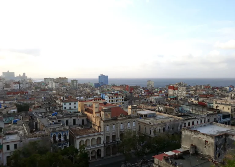
Havana occupies the northwestern coast of the main island. Its historic harbor and position in Spanish Atlantic shipping helped it develop into an important port and shipbuilding center. UNESCO’s description of Old Havana connects its fortifications to the protection of that maritime role.
The historic center retains a network of plazas, narrow streets and buildings with courtyards, balconies and arcades. Its urban form records trade, administration and everyday life as well as military defense. Modern Havana is larger than the World Heritage property, so the protected historic center should not be mistaken for the full city.
Cuba’s settlement geography extends well beyond the capital. Provincial centers and rural communities occupy different parts of the main island, while Isla de la Juventud has a separate island setting. In ONEI’s end-2025 effective-population release, Havana province had 1,673,208 people and the special municipality of Isla de la Juventud had 71,132. These are administrative-area figures, not directly comparable measurements of two urban footprints.
Sea separation also changes the meaning of distance. An offshore island may be near the main island on a map but require a different transport connection from a town reached overland. Looking at water crossings, terrain and the location of services gives a more useful picture than distance alone.
7. Government and Economic Geography
The 2019 Constitution names Havana as the capital and Spanish as the official language. It defines Cuba as a socialist republic and assigns the Communist Party the leading political role. The president is head of state, while the prime minister is head of government. Our explanation of Cuba’s political system examines that narrower subject in more detail.
Economic activity also reflects differences between landscapes. Tobacco farming is closely associated with western agricultural areas, while tourism draws on coastal resorts, historic cities and natural landscapes. Nickel, agriculture and specialized services are additional parts of the national economy. These activities have different spatial requirements: a port, a farm and a protected mountain landscape cannot be understood through the same map layer.
The archipelago’s external connections depend heavily on maritime and air links. Its position near major Caribbean passages is a geographic advantage, but location alone does not determine trade volumes or household living standards. Transport capacity, economic policy and international relationships also shape what those connections deliver.
What Did We Learn Today?
Cuba is an archipelago whose main island contains contrasting plains, limestone valleys and mountain systems. Isla de la Juventud and the smaller cays extend the country beyond that familiar outline. Water links uplands, aquifers and coastal wetlands, while Havana’s harbor history shows how location influences settlement. Dated population definitions and clearly scoped maps keep the physical island, national territory and administrative areas distinct.
Sources & Data Notes
The main population figure is ONEI’s effective-population estimate at the end of 2025, published through its official channel; it is not a census or the same series as the UN’s 2025 projection. Area follows the UNData surface-area series for 2023. Older FAO material is used only for stable physical geography and broad climatic seasonality, not historical administrative or demographic figures. Statistical and map conventions were checked November 16, 2026.
- ONEI: end-2025 effective population and provincial figures
- ONEI: explanation of the effective-population method, post 1456
- UNData: 2023 surface area and separate 2025 population projection
- Cuba’s 2019 Constitution, reproduced by Chile’s Library of Congress: Articles 1, 2, 5, 125 and 140
- Cuba’s official tourism portal: archipelago and major landforms
- Cuba’s official tourism portal: administrative divisions and economic sectors
- Cuba’s official tourism portal: Isla de la Juventud landscapes
- Cuba’s official tourism portal: the Cauto plain and Sierra Maestra
- UNESCO: Viñales Valley, karst and agricultural landscape
- UNESCO: Alejandro de Humboldt National Park, geology and ecosystems
- FAO: physical geography, groundwater and broad seasonal climate
- UNESCO: Ciénaga de Zapata Biosphere Reserve habitats
- UNESCO: Old Havana, its harbor history and urban form
- U.S. Army Corps of Engineers, May 2025: Guantánamo base jurisdiction and Cuban sovereignty
Map method: Original GeographyPin cartography uses public-domain Natural Earth coastlines, country components, lakes and Havana point. The generalized map includes the main island and surrounding islands, but not every tiny cay. Sierra Maestra and Isla de la Juventud reference points come from GeoNames under CC BY 4.0; their coordinates were reprojected and rendered as labeled markers, not regional boundaries. Viñales uses UNESCO’s site-reference coordinate, not a new protected-area outline. Relief uses Mapzen Terrain Tiles with USGS SRTM/GMTED2010 elevation and is qualitative. Elevation colors are not vegetation classes. Local Guantánamo base jurisdiction and maritime limits are not delineated. The featured image is a decorative flag-filled outline, not a jurisdictional survey.