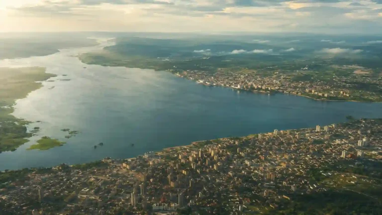
The Democratic Republic of the Congo is often associated with an immense rainforest and a powerful river. Both are central to its geography, but neither tells the whole story. Eastern mountains, southeastern mineral-producing uplands and a narrow Atlantic outlet create a country whose landscapes and connections vary enormously.
The Democratic Republic of the Congo, or DRC, is a Central African country with Kinshasa as its capital. Much of its interior belongs to the Congo River basin, while higher terrain rises toward the east and southeast. A narrow western outlet reaches the Atlantic Ocean. It is a separate country from the Republic of the Congo, whose capital is Brazzaville.
How to use this article: Distinguish the two countries, compare the major landscapes, or follow the Congo River’s connections and obstacles.
1. Locate the DRC and distinguish the two Congos
The DRC straddles the equator in Central Africa. Its neighbors are the Republic of the Congo, Central African Republic, South Sudan, Uganda, Rwanda, Burundi, Tanzania, Zambia and Angola. Tanzania faces the DRC across Lake Tanganyika, while Angola’s Cabinda exclave is part of the western border setting.
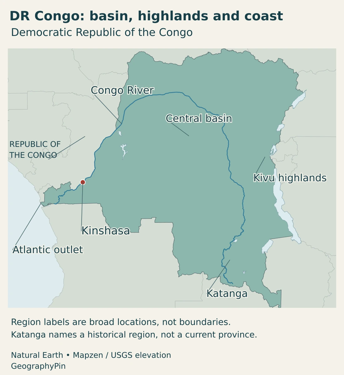
The country is not landlocked. Its western territory reaches the Atlantic near the lower Congo River, although that coastal frontage is small compared with the enormous inland territory. Kinshasa itself is inland, so capital-city location and national access to the ocean should not be confused.
DR Congo is not the Republic of the Congo
The Democratic Republic of the Congo and the Republic of the Congo are separate sovereign states. Their capitals, Kinshasa and Brazzaville, face one another across the Congo River. “Congo-Kinshasa” and “Congo-Brazzaville” are useful informal distinctions, but the formal country names remain different.
The name Congo also refers to the river and its international drainage basin. The basin extends beyond either country’s borders. Our explanation of why there are two Congos covers the naming and historical distinction in more detail.
2. Country facts and Kinshasa
| Item | Detail |
|---|---|
| Capital | Kinshasa |
| Population | About 112.8 million: UN medium-fertility projection for 2025, not a census count. |
| Published surface area | About 905,568 sq mi (2,345,410 km²), UN profile figure with a 2023 reference. |
| Official language | French |
| National languages | Kikongo, Lingala, Swahili and Tshiluba, as named in the Constitution. |
| Currency | Congolese franc (CDF) |
| Provincial-level organization | Kinshasa and 25 provinces; Kinshasa has provincial status. |
| Ocean access | Atlantic Ocean through the narrow western outlet. |
The UN population table reports 112,832 thousand for 2025; the rounded figure here avoids implying a new enumeration. Area is the published UN surface-area figure, not a calculation from this article’s map. Reference dates differ, and square miles are rounded.
The population figure is a dated demographic projection, not a recent nationwide enumeration. The national census organizer identifies 1984 as the last scientific census. This long interval makes it especially important to keep a projected population separate from a counted one and to avoid treating extra decimal places as certainty.
Kinshasa is the capital and seat of national institutions, with the status of a province. A population reported for Kinshasa’s administrative territory is not automatically equivalent to a built-up-city or metropolitan estimate. The national total and city figures also require matching reference dates before comparison.
3. Congo basin, eastern highlands and Katanga
Four settings within a continental-scale country
| Setting | Landscape | Geographic significance |
|---|---|---|
| Central Congo basin | Extensive lower-lying country, rivers, wetlands and tropical forest. | Forms the core of a large drainage network and many inland water connections. |
| Eastern Rift highlands | Mountain ranges, escarpments, volcanic landscapes and border lakes. | Creates sharp elevation contrasts and environments unlike the central lowlands. |
| Southeastern uplands and Katanga region | Higher interior country, including the copper-producing southeast. | Connects mineral geography with settlements and routes toward Zambia. |
| Lower Congo and Atlantic outlet | Western river corridor and a narrow ocean frontage. | Gives the country maritime access, while rapids complicate the connection with the interior. |
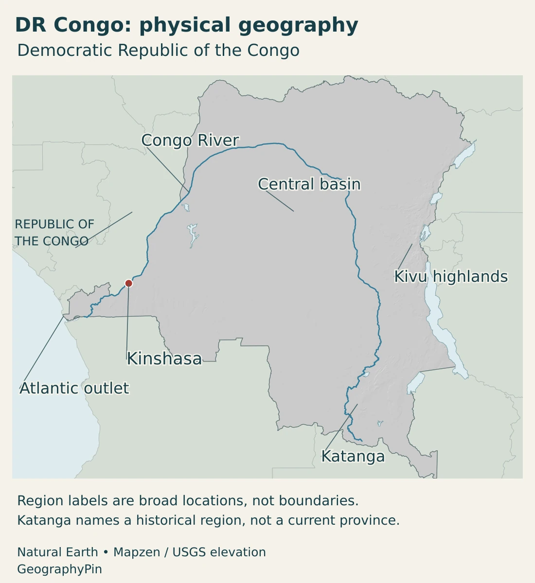
The central basin is not the entire country, and the entire basin is not one uninterrupted forest. Rivers, wetlands, settlements and different land uses occupy the lowlands. Around the basin, higher terrain creates other environmental settings.
In the east, the Virunga and Rwenzori landscapes show how dramatically relief can rise. UNESCO’s description of Virunga National Park includes lava plains, savannas, wetlands and high mountain environments. This variety is very different from the image of a uniformly flat equatorial country.
Kivu identifies an eastern lake and a wider geographic area. North Kivu and South Kivu are administrative names within that broader setting; the physical landscape does not follow every provincial boundary. Lake Kivu is shared with Rwanda rather than lying wholly inside the DRC.
Katanga is useful as a historical and broad southeastern regional name, but it should not be read as one present-day province. Mineral-producing areas in today’s Haut-Katanga and Lualaba provinces form part of this wider southeastern setting. A physical map can retain the familiar regional label without restoring an obsolete administrative unit.
4. Climate, forests and the Congo River
Equatorial lowlands generally have warm conditions and frequent rainfall, while more distinct wet and dry seasons occur farther north and south. Higher eastern terrain can be considerably cooler than the central basin. Latitude, elevation and regional circulation all contribute to these contrasts.
Rainfall seasonality is not identical on both sides of the equator, and a national average can hide important regional differences. A description of the central rainforest therefore cannot be used as a weather guide for every part of the southeastern uplands or the eastern mountains.
The country’s forests and wetlands are closely connected with water, but forest extent and drainage-basin extent measure different things. The Congo basin includes landscapes beyond the DRC, and a river catchment does not consist only of forest. This distinction matters when comparing environmental maps and country statistics.
A river network, not an uninterrupted shipping canal
The Congo River and its tributaries form the principal drainage network across much of the country. The river follows a great arc through the interior before turning toward the Atlantic. Tributaries connect distant parts of the basin rather than running only within one province or one country.
Long river reaches provide important inland transport connections, but the route is not continuously navigable from the interior to the ocean. Below the Kinshasa area, powerful rapids and changes in elevation interrupt the lower river. Their presence explains why a major river on a national map is not automatically a continuous sea-going shipping route.
Matadi, Boma and the Atlantic outlet occupy a different transport setting from the upper inland river network. Moving goods between inland waters, roads, railways and maritime facilities requires connections between transport modes. The geography of a route includes its obstacles and transfer points, not just its length.
Lake Tanganyika adds another part of the international water system on the eastern border. Its Lukuga outlet connects westward with the Congo basin. Large lakes and river tributaries therefore link the country to neighboring catchments, while changes in water levels or land use can have effects beyond one jurisdiction.
5. Cities, provinces and languages
Kinshasa’s river position gives it a different setting from Lubumbashi and Kolwezi in the mineral-producing southeast. Kisangani belongs to the inland Congo River network. These urban locations reflect administration, transport and economic connections rather than a uniform distribution across the national territory.
The Constitution organizes the country into Kinshasa and 25 provinces, with Kinshasa itself having provincial status. This is often summarized as 26 provincial-level units. Older references to larger former provinces can remain useful geographically, but they should not be substituted for the current legal list.
Official and national languages have different roles
French is the official language. The Constitution identifies Kikongo, Lingala, Swahili and Tshiluba as national languages. These are distinct legal categories, not a claim that only five languages are spoken or that all communities use them in the same way.
The political structure also needs to be distinguished from conditions on the ground. Constitutional provincial boundaries do not describe every area’s actual security situation or the control of particular routes.
UNHCR’s August 2026 regional update reported that violence in the east continued to drive displacement and protection risks despite mediation efforts. This profile describes national geography, not current front lines or safe travel routes. A generalized country map should not be interpreted as a live security assessment.
6. Minerals, energy and transport connections
The DRC has a constitutional republic framework with a president and a prime minister. The Constitution provides for the prime minister’s appointment from the parliamentary majority. These institutional descriptions should not be confused with an assessment of political conditions or effective control in every part of the country.
Copper and cobalt provide a clear example of economic geography. USGS reporting identifies major production in the southeast, including Lualaba and Haut-Katanga. Mines, processing facilities and cities such as Kolwezi and Lubumbashi form a regional concentration; mineral activity is not spread evenly across the national territory.
That southeastern concentration is different from the forested central basin and from the eastern Kivu setting. Describing every part of the DRC as one interchangeable “mining region” obscures the differences between deposits, landscapes and transport connections.
The lower Congo offers a second example. At Inga, large river flows and a natural drop associated with rapids create hydropower opportunities. Potential generating capacity is not the same as electricity currently delivered to households or businesses, and proposed development should not be presented as completed infrastructure.
The Atlantic outlet adds a third connection. The country has direct access to the sea, yet much of its territory lies far inland, separated from coastal facilities by long distances and difficult transport links. A coastline alone does not eliminate the challenges of moving goods through a very large country.
Understanding the DRC therefore requires more than a list of resources. The basin, mountains, mineral-bearing southeast and lower river corridor occupy different positions in the national system. Their connections, and the constraints on those connections, explain why geography matters for daily life and economic activity.
Frequently Asked Questions
Is the Democratic Republic of the Congo landlocked?
No. It has a narrow Atlantic coastline near the lower Congo River. Kinshasa is inland, and the country’s large interior still depends on connections between river, land and maritime transport.
Are the DRC and the Republic of the Congo the same country?
No. The DRC has Kinshasa as its capital; the Republic of the Congo has Brazzaville. The two capitals face each other across the Congo River.
Is the Congo River basin entirely inside the DRC?
No. The basin extends across several countries. Its boundary follows drainage, not the DRC’s national border, and it is not identical to the extent of rainforest.
What Did We Learn Today?
The DRC combines the central Congo basin with eastern highlands, southeastern uplands and a narrow Atlantic outlet. Kinshasa is its capital, distinct from Brazzaville in the neighboring Republic of the Congo. The river connects much of the interior, but rapids complicate the route to the ocean. Country borders, drainage basins, forests and current security conditions are different layers of geography.
Sources & Data Notes
Statistical reference dates and definitions are stated beside the figures. Physical regions are broad geographic descriptions, not additional administrative units. Reviewed in November 2026.
- UNData, DRC country profile: 2025 medium-fertility population projection, surface area with a 2023 reference, capital and currency.
- UNFPA, DRC population dashboard: 2025 midyear demographic projection, using World Population Prospects 2024.
- INS/BCR, census questions and answers: National census organizer’s explanation of the 1984 census and subsequent census context.
- Constitution, amended text hosted by WIPO: Articles 1, 2 and 78: languages, capital, provinces and appointment of the prime minister.
- DRC National Adaptation Plan 2022–2026: Physical setting and drainage, including the central basin, eastern uplands and Atlantic opening.
- USDA Foreign Agricultural Service, country overview: February 2025 report: broad regional climate contrasts.
- UNESCO, Virunga National Park: Diversity of eastern landscapes, from lava plains and wetlands to mountain environments.
- Rwanda Environment Management Authority, Lake Kivu: Lake Kivu’s shared Rwanda–DRC setting and Rift geography.
- Burundi’s Lake Tanganyika tentative-list submission: Lake Tanganyika’s Lukuga outlet toward the Congo basin. This is a state-party tentative-list submission, not a World Heritage inscription.
- Lake Tanganyika Authority, contracting countries: The four riparian countries, including Tanzania and the DRC.
- USGS, field investigation of the lower Congo: Primary hydrologic observations of the powerful rapids below Kinshasa.
- IFC, DRC private-sector diagnostic: March 2022, transport section: Matadi, Boma and the maritime outlet, and connections between river, rail and roads.
- USGS, Congo (Kinshasa) minerals reporting: 2024 minerals reporting: copper and cobalt geography in Lualaba and Haut-Katanga.
- World Bank, Inga development background: Updated June 2025: lower-Congo hydropower setting. Proposed capacity is distinct from operating infrastructure.
- UNHCR, regional update for August 2026: Dated account of conflict-related displacement and protection risks; not a live security or route assessment.
Map sources and scope: Original GeographyPin maps use public-domain Natural Earth country outlines, river lines, lake polygons and city coordinate attributes. The complete DRC source outline is retained, with the Republic of the Congo shown as a separate neighbor. Boundaries are generalized geographic reference data, not an official claims map or a survey of current military control.
Central basin, Kivu highlands and Katanga are broad orientation labels, not mapped drainage or administrative boundaries. Katanga is a historical regional name. The Congo and Lualaba follow actual source lines; the lower estuary is omitted from the source river line, so the drawn line is not a complete source-to-mouth route. Lake polygons extend across borders where the source does. These are not current water-level measurements or determinations of lake-boundary claims. Kinshasa’s marker identifies a source location, not the extent of the urban area.
Shaded relief is calculated from real elevations accessed through Mapzen Terrain Tiles. Global elevation data courtesy of the U.S. Geological Survey. Elevation-source attribution and terms apply. Shading represents terrain form rather than numerical elevation bands or local navigation detail.
The cover uses DR Congo flag artwork by Nightstallion and Commons contributors in the country-outline motif, alongside an intact flag, decorative divider and GeographyPin branding.