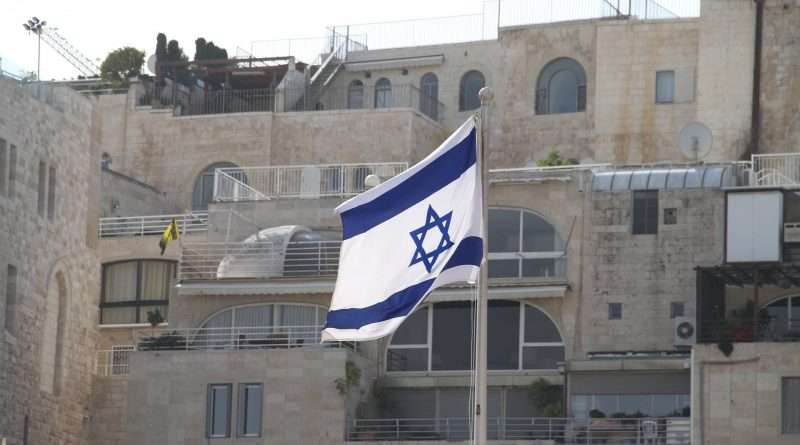
Capital of Israel: Jerusalem
Jerusalem is Israel’s capital and seat of the Knesset (parliament), Supreme Court, and government ministries. Set at about 2,575 ft (785 m) above sea level in the Judaean Mountains, the city is holy to three major religions and—since 1980—its status as Israel’s capital is anchored in Israeli Basic Law.
Why Jerusalem Is Israel’s Capital (Law & Government)
Israel designates Jerusalem as its capital in a quasi-constitutional Basic Law adopted by the Knesset in 1980. The law states that “Jerusalem, complete and united, is the capital of Israel.” It also establishes that the President, the Knesset, the Government, and the Supreme Court have their seats there. This is the legal foundation for Jerusalem’s capital status in Israeli law and practice.
In everyday terms, national institutions sit in Jerusalem: the Knesset and most ministries in Giv’at Ram and Kiryat HaMemshala; the Supreme Court opposite the Knesset; the Prime Minister’s Office nearby; and the President’s Residence in Talbiya. For Israeli citizens, Jerusalem is where laws are passed, budgets are set, and supreme judicial rulings are made.
Government precinct & national institutions
The area around the Knesset forms the national precinct (Kiryat HaLe’om): legislature, Supreme Court, Israel Museum and Shrine of the Book (Dead Sea Scrolls), Bank of Israel, and major ministries. The concentration of state functions in one district is typical of capital cities and shapes land use, security planning, and daily commutes.
| National Institution | Neighborhood / District | Function |
|---|---|---|
| Knesset (Parliament) | Giv’at Ram | Legislative branch |
| Supreme Court | Opposite Knesset | Highest judicial authority |
| Prime Minister’s Office | Kiryat HaMemshala | Executive coordination |
| President’s Residence | Talbiya | Head of state residence |
Geography & Urban Layout
Jerusalem sits on a high limestone ridge between two major landforms: the Mediterranean coastal plain to the west and the Dead Sea Rift to the east. The city averages about 2,575 ft (≈785 m) above sea level, which brings cooler, drier summers than the coast and occasional winter snow. Steep valleys—chiefly the Kidron and Hinnom—carve natural boundaries that shape roads, neighborhoods, and views.
From west to east the skyline steps over a series of ridges: Mount Herzl and Yad Vashem, the government quarter around the Knesset, the historic city center along Jaffa Road, and then the Mount of Olives and Mount Scopus on the far ridge (both just over 2,700 ft / ≈825 m). The Old City sits in a shallow saddle between these heights, while modern Jerusalem spreads mainly west, north, and south onto broader hilltops. Local rules require pale “Jerusalem stone” facades. The stone gives the city a distinctive, uniform look.
The street pattern reflects the terrain. Main arteries follow ridgelines; shorter streets drop as stair-stepped lanes toward the valleys. Green corridors—such as the Valley of the Cross and the Jerusalem Forest—thread into the urban fabric. New infrastructure (the Red Line light rail and intercity rail to Navon Station) ties the hilly core to outlying districts. For visitors, distances are short but elevation changes are frequent. A 15–30 minute walk can include several hundred feet (tens of meters) of ascent and descent.
The Old City & UNESCO status
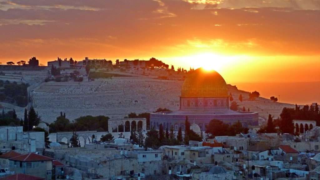
Enclosed by 16th-century walls rebuilt under Sultan Suleiman (≈1535–1541) and measuring about 2.5 mi (≈4 km) in circuit, the Old City covers roughly 0.35 sq mi (≈0.9 km²). Within its four traditional quarters—Jewish, Muslim, Christian, and Armenian—stand the Western Wall, the Church of the Holy Sepulchre, and al-Aqsa Mosque/Dome of the Rock on the Temple Mount/Haram al-Sharif. Because of its extraordinary concentration of sacred sites and conservation pressures, the “Old City of Jerusalem and its Walls” is a UNESCO World Heritage property and has appeared on the “in danger” list since 1982 to spotlight the need for careful preservation and management.
Ancient and Modern History of Jerusalem
Jerusalem’s story stretches across more than 3,000 years. Long before the modern State of Israel (established in 1948), the city was a royal capital, a temple center, and a crossroads of empires. Understanding this timeline explains why Jerusalem carries such exceptional religious meaning and why it became Israel’s political heart in the present day.
Jerusalem’s Ancient Origins (King David to the Second Temple)
Around 1000 BCE, King David captured the Jebusite stronghold and made Jerusalem the capital of the United Kingdom of Israel. His choice united the northern and southern tribes around a neutral hilltop city and tied kingship to worship by bringing the Ark of the Covenant to the “City of David.” David’s son, King Solomon, built the First Temple in the 10th century BCE, establishing Jerusalem as the spiritual center of the Jewish people.
The First Temple was destroyed by the Babylonians in 586 BCE, leading to exile. After the Persian conquest, returning Judeans rebuilt the sanctuary; the Second Temple was dedicated in 516 BCE and later greatly enlarged under Herod the Great (late 1st century BCE). Although the Romans destroyed the Second Temple in 70 CE, parts of the Temple platform’s retaining works remain, including the Western Wall. This ancient sequence—Davidic capital, First Temple, and enduring memory of the Second Temple—anchors the Jewish connection to Jerusalem and the idea of a Jewish capital across millennia.
The City Divided (1948–1967)
Modern political fault lines took shape in the mid-20th century. Following the 1948 Arab–Israeli War and the 1949 Armistice Agreements, Jerusalem was split by fortified lines: West Jerusalem came under Israeli control; East Jerusalem—including the Old City and major holy sites—came under Jordanian control. Barriers and no-man’s-land zones cut through neighborhoods; passage between the halves was limited to the Mandelbaum Gate. From 1948 to 1967, Jews could not access the Western Wall, and movement among sacred places was tightly restricted, reflecting the city’s tense, divided reality.
In June 1967, during the Six-Day War, Israel took control of East Jerusalem. Israeli law and administration were subsequently extended to the eastern sectors, and municipal systems were integrated—steps that Israel describes as the city’s reunification. These actions became the legal and political backdrop for later measures, notably the 1980 Basic Law declaring Jerusalem the capital, which are discussed in the governance section of this article.
Religious Significance to the Three Faiths
Jerusalem’s identity is inseparable from faith. Within a short walk, people encounter places tied to the Hebrew Bible, the life of Jesus, and the Prophet Muhammad’s Night Journey. This dense layering of sacred memory explains both the city’s magnetic pull on pilgrims and the care—and tension—surrounding its holy places. Noise, markets, and traffic fade at threshold stones: here, devotion sets the pace.
For visitors, remember that these sites are living places of worship. Modest dress, quiet speech, and respect for prayer areas help keep access open to everyone. Security checks and crowd controls are common on busy days and religious holidays, and opening hours can change without notice due to ceremonies or safety considerations.
Judaism: The Eternal Holy City
For Jews, Jerusalem (Yerushalayim) is the spiritual center of prayer and memory. The Western Wall (HaKotel) is the closest accessible point to the ancient Temple Mount—specifically, to the site of the Holy of Holies—making it the holiest place where Jews are permitted to pray. Notes slipped between stones symbolize personal appeals to God and a bond that spans centuries. Jewish prayer direction (mizrah) faces Jerusalem; within the city, prayers traditionally turn toward the Temple Mount itself, reflecting the centrality of the First and Second Temples to Jewish worship and nationhood.
Christianity: Sites of the Passion
For Christians, Jerusalem anchors the story of Jesus’s final days. Pilgrims trace the Via Dolorosa through the Old City, recalling the Stations of the Cross from condemnation to crucifixion. Nearby, the Church of the Holy Sepulchre—shared by several ancient denominations—encompasses, according to long tradition, both Golgotha (Calvary) and the tomb where Jesus was laid and from which he rose. Lit candles, processions, and hymns turn narrow streets into sanctuaries, especially during Easter and other feast days.
Islam: Al-Quds and the Night Journey
For Muslims, Jerusalem (Al-Quds, “The Holy”) is Islam’s third holiest city after Mecca and Medina. On the Noble Sanctuary (Haram al-Sharif) stand the Dome of the Rock and Al-Aqsa Mosque. Islamic tradition holds that the Prophet Muhammad was transported by night to “the farthest mosque” (al-Masjid al-Aqsa) and ascended from the Rock on a heavenly journey (al-Isrā’ wal-Mi‘rāj). The precinct’s broad plazas and arcades host daily prayers and major gatherings during Ramadan, making it both a sacred landscape and a living center of community life.
People, Languages, and Daily Life (Demographics & Society)
Jerusalem is Israel’s largest city by population. According to the Israel Central Bureau of Statistics (CBS), Jerusalem crossed the one-million-resident threshold around Jerusalem Day 2024, reflecting steady natural growth. The CBS release for end-2023 reports about 60.5% “Jews and Others” and 39.5% Arabs among residents.
Hebrew and Arabic are widely heard on the street, alongside English. The city’s population is young relative to many Western capitals, driven by high fertility rates in ultra-Orthodox Jewish and Arab neighborhoods. University life (Hebrew University on Mount Scopus and Giv’at Ram), hospitals (Hadassah Ein Kerem), and a growing technology sector (Har Hotzvim; companies like Mobileye) add a modern layer to a city defined by pilgrimage and administration.
Politics & International Recognition (What the World Does)
While Israel’s law and institutions locate the capital in Jerusalem, international recognition varies. Some countries have relocated their embassies to Jerusalem (the United States officially opened its embassy there on May 14, 2018), while many others keep embassies in Tel Aviv and maintain consulates or representative offices in Jerusalem. The U.S. move followed a 2017 presidential recognition statement and the long-standing (1995) Jerusalem Embassy Act.
Diplomatic positions continue to evolve. In December 2024, Paraguay reopened its embassy in Jerusalem, joining a small group (including the U.S., Guatemala, Honduras, Kosovo, and Papua New Guinea) with embassies in the city.
At the same time, UN Security Council Resolution 478 (1980) critiqued Israel’s 1980 Basic Law on Jerusalem and called on member states to withdraw diplomatic missions—illustrating the long-running dispute over the city’s final status and borders.
Visiting Jerusalem (Practical Geography & Travel Tips)
Getting there: Ben Gurion Airport (TLV) is about 33–35 mi (53–56 km) from central Jerusalem by road. The electric high-speed rail links TLV to Jerusalem–Navon Station near the city center in roughly 25–30 minutes. Within the city, the light-rail “Red Line” runs through Jaffa Road and links neighborhoods to the Old City area.
When to go: Spring (March–May) and autumn (September–November) have pleasant, dry weather. Summers are warm but less humid than the coast thanks to elevation; winters can be rainy with occasional snow.
What to see: The Old City’s quarters and holy sites; Mount of Olives viewpoints; the Israel Museum and Shrine of the Book (Dead Sea Scrolls); Machane Yehuda Market; Yad Vashem on Mount Herzl; and modern civic architecture around the Knesset and Supreme Court.
How the city is laid out: Expect steep streets and stone stairways. Major green spaces include the Valley of the Cross and the Jerusalem Forest to the west. Outbound roads connect to Tel Aviv (Hwy 1), the Dead Sea (Hwy 1/90), and the Hebron/Bethlehem corridor (Hwy 60).
Key Facts & Figures (Table)
A quick, practical snapshot of Jerusalem as a capital—law, location, size, people, and how to get around. Distances and times are approximations for easy trip planning.
| Metric | Value |
|---|---|
| Status in Israeli law | Capital under Basic Law: Jerusalem, Capital of Israel (1980) |
| Coordinates (City Hall) | 31.7683° N, 35.2137° E |
| Elevation (average / highest ridges) | ≈2,575 ft (≈785 m) / ≈2,700 ft (≈820 m) |
| Municipal area | ≈48.3 sq mi (≈125 km²) |
| Population (CBS) | Surpassed ~1,000,000 in 2024; Israel’s largest municipality |
| Languages in daily use | Hebrew, Arabic; English widely used in tourism/academia |
| Currency | Israeli new shekel (ILS) |
| Time zone | Israel Standard Time UTC+2 (winter) / Israel Daylight Time UTC+3 (summer) |
| UNESCO status (Old City) | World Heritage; “In Danger” list since 1982 |
| Getting Around & Distances | Approximate Figures |
|---|---|
| Ben Gurion Airport (TLV) → Central Jerusalem | 33–35 mi (53–56 km) by road; 25–30 min by high-speed rail to Navon Station |
| Old City proximity to city center | Walkable; Damascus Gate & Jaffa Gate ≈0.6–1.2 mi (1–2 km) from central hubs |
| Light Rail (Red Line) | Runs via Jaffa Road; key stops include Central Station, City Hall, Damascus Gate |
| Road links | Hwy 1 (Tel Aviv); Hwy 60 (Bethlehem/Hebron); Hwy 1/90 (Dead Sea) |
| Jerusalem ↔ Tel Aviv (city center) | ≈34 mi (≈55 km) by road; ≈25–30 min by rail |
| Jerusalem ↔ Dead Sea (nearest beaches) | ≈22–31 mi (≈35–50 km) depending on site (e.g., Kalia/Northern Basin) |
| Climate Snapshot (typical) | Value |
|---|---|
| Climate type | Mediterranean (Köppen Csa): hot, dry summers; cool, wet winters |
| Summer daytime average (July–Aug) | ≈84 °F (≈29 °C); evenings ≈64 °F (≈18 °C) |
| Winter daytime average (Jan) | ≈54 °F (≈12 °C); nights ≈43 °F (≈6 °C) |
| Annual precipitation | ≈21.5–22 in (≈545–560 mm), mostly Nov–Mar; occasional snowfall |
FAQ
Is Jerusalem internationally recognized as Israel’s capital?
Recognition varies. Some countries (e.g., the U.S., Paraguay in 2024, Guatemala, Honduras, Kosovo, Papua New Guinea) have embassies in Jerusalem; many others keep embassies in Tel Aviv. UN Security Council Resolution 478 (1980) criticized Israel’s 1980 law and urged states to withdraw missions, so positions differ by country.
Why is Jerusalem important to three religions?
For Jews, it is the site of the First and Second Temples and the Western Wall; for Christians, Jesus’s crucifixion and resurrection; for Muslims, the Prophet Muhammad’s Night Journey and the al-Aqsa Mosque/Dome of the Rock. The Old City concentrates many of these sites within one square kilometer.
How high is Jerusalem, and does it snow?
The city averages about 2,575 ft (785 m) in elevation. Its winters are cool and wet; rare snowfalls can occur (more likely on the highest ridges like Mount Scopus and the Mount of Olives).
What language will I hear most in the capital?
Hebrew and Arabic are both common; English is widely used in tourism and higher education. Street signs and public transit information typically appear in Hebrew, Arabic, and English.
How big is Jerusalem compared with Tel Aviv?
By municipal population, Jerusalem is larger; by GDP and finance, Tel Aviv is Israel’s business hub. The two cities are linked by highway and high-speed rail (roughly 53–56 km / 33–35 mi between centers).
Is the Old City part of modern municipal Jerusalem?
Yes. The Old City lies within today’s municipal boundaries and is a UNESCO World Heritage site listed “in danger” since 1982 because of conservation and governance concerns.
What Did We Learn Today?
- Jerusalem is Israel’s seat of government under the 1980 Basic Law, housing the Knesset and Supreme Court.
- The city stands high—about 2,575 ft (785 m)—giving it a cooler, drier climate than the coast.
- The Old City is a UNESCO World Heritage property and has been on the “in danger” list since 1982.
- Population passed ~1,000,000 around Jerusalem Day 2024, per the Israel CBS.
- International recognition is mixed: some embassies are in Jerusalem; many remain in Tel Aviv.