Caspian Sea: The Largest Lake in the World
The Caspian Sea is the world’s largest lake by surface area—about 149,200 square miles (≈386,400 square kilometers) at recent levels—and its deepest point plunges to ~3,360 feet (1,025 meters). It is endorheic (no natural outflow), mildly salty on average, and fed chiefly by the Volga River system.
Where & What Is the Caspian Sea?
Geographically, the Caspian sits east of the Caucasus and west of the Central Asian steppe, between about 36.3°–47.1° N and 45.4°–54.2° E. It’s a classic endorheic basin: water flows in from over 130 rivers but exits mainly by evaporation. This dual identity—brackish “sea,” landlocked lake—explains its unique physical and legal character.
Historically, its surface area has been quoted in two bands—about 143,200 square miles (371,000 square kilometers) in many popular references and ~149,200 square miles (386,400 square kilometers) in encyclopedic treatments—reflecting water-level variability across decades. Think of the difference as a moving shoreline rather than a fixed number.
Size, Depth & Salinity — Key Facts
At today’s levels (as of 2025), the Caspian’s maximum depth is ~3,360 feet (1,025 meters), and average salinity sits around 12–13 parts per thousand (about one-third of ocean water). Total volume is roughly 18,800 cubic miles (≈78,200 cubic kilometers), or about one-third of Earth’s inland surface water.
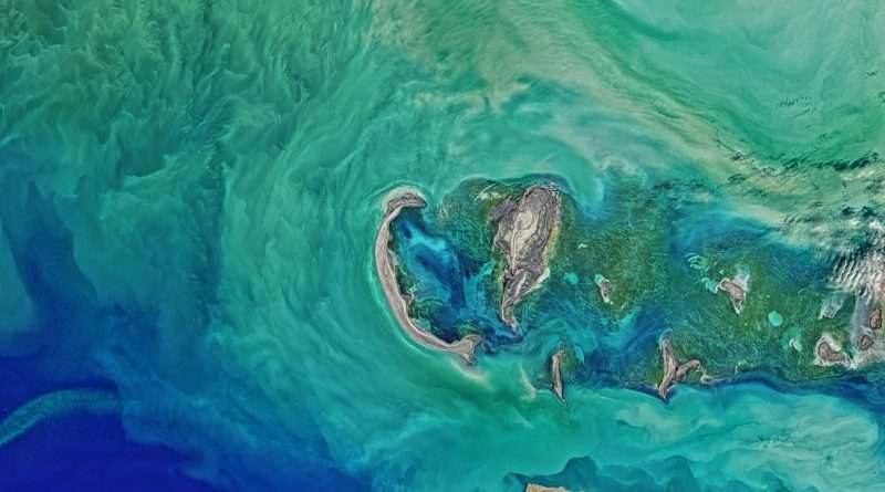
Because the Caspian is long and uneven in depth, conditions vary widely: its shallow north often freezes in winter, while the deep south holds the greatest volume. Salinity is lowest near the Volga’s mouth in the north and peaks in hyper-saline side basins like Kara-Bogaz-Gol (Garabogazköl).
The Three Natural Basins
Experts divide the Caspian into the North (very shallow), Middle, and South basins. The North averages just a few meters deep; the Middle averages ~190 meters; the South exceeds 1,000 meters. This structure drives different ice, salinity, and ecological patterns from one end to the other.
| Metric | Value (imperial & metric) |
|---|---|
| Surface area (variable) | ~143,200–149,200 sq mi (371,000–386,400 km²) |
| Length (N–S) | ≈750 mi (≈1,200 km) |
| Average width | ≈200 mi (≈320 km) |
| Max depth (South basin) | ~3,360 ft (1,025 m) |
| Average depth | ~690 ft (211 m) |
| Volume | ~18,800 cu mi (≈78,200 km³) |
| Mean salinity | ≈12–13‰ (≈1.2–1.3%) |
Values compiled from Encyclopædia Britannica and other technical summaries; area varies with water level.
How the Caspian “Works”: Rivers, Balance & Endorheic System
The Caspian has no natural outlet to the world ocean. Its water budget balances inflow (chiefly rivers) against evaporation. The Volga, Ural, and Terek deliver most of the freshwater; in fact, the Volga system alone accounts for the overwhelming majority—around 80–88%—of river inflow.
Because the north receives the freshest water, it’s the least saline and biologically distinct. Evaporation dominates toward the east and south, especially near Kara-Bogaz-Gol, where salts concentrate intensely. Over years to decades, shifts in river discharge and climate drive the Caspian’s famous level swings—meters up or down—redrawing coasts and deltas.
Nature of the Caspian — Seals, Sturgeon & Conservation
The Caspian seal (Pusa caspica) is the only marine mammal endemic to the sea; its numbers have fallen sharply over the last century and remain threatened. Protecting ice-breeding sites in the north and reducing pollution and bycatch are urgent priorities identified by conservation bodies.
Sturgeon once made the Caspian synonymous with caviar. Yet overfishing, poaching, blocked spawning runs, pollution, and habitat loss cratered stocks; strict bans and restocking programs exist, but recovery is slow and uneven. Managing river connectivity and illegal harvest remains as critical as any headline policy.
People, Ports & Energy — Why the Caspian Matters
From Baku’s offshore fields to Kazakhstan’s ports, the Caspian underpins regional economies via oil, gas, fisheries, and shipping. Despite being landlocked, it connects to the Black Sea and Baltic through Russia’s Volga–Don and Volga–Baltic canals, letting tankers and ferries reach broader markets.
Law & Borders — Is It a Sea or a Lake?
Politically, the Caspian has long sat between definitions. In 2018 the five littoral states signed the Convention on the Legal Status of the Caspian Sea (Aktau, Kazakhstan), establishing a special regime tailored to this unique, landlocked water body.
What the 2018 Convention Sets
Each state controls up to 15 nautical miles (≈17.3 miles / 28 kilometers) of territorial waters and an additional 10 nautical miles (≈11.5 miles / 19 kilometers) as an exclusive fishing zone. The agreement clarifies how the water surface, seabed, and subsoil are used and delimited—crucial for hydrocarbons and fisheries.
Shrinking Shorelines — Water-Level Swings & Climate Risk
Since the mid-1990s the Caspian’s level has trended downward. Satellite analyses project a possible drop of ~9–18 meters (30–59 feet) by 2100 if warming continues, potentially exposing tens of thousands of square miles (≈93,000 km²) of new land and stressing ports, wetlands, seals, and sturgeon.
Regional briefings underscore the urgency. UNEP’s 2024 working paper warns of impacts over the next 50 years, while reporting and officials around COP summits have flagged record or near-record lows and costly dredging to keep shipping lanes open. For a visual explainer, see NASA’s Earth Observatory feature on the Caspian’s shallow north.
FAQ
Is the Caspian Sea a sea or a lake?
Hydrologically it’s a lake (endorheic, no ocean outlet). Legally it has a special status set by the 2018 Convention—neither treated exactly like a typical “sea” nor a simple “lake”—with specific territorial waters and fishing zones for each country.
How big is it, really?
Expect ~143,200–149,200 sq mi (371,000–386,400 km²) depending on water level and what’s included (e.g., excluding/including side lagoons). That spread reflects natural fluctuation rather than conflicting facts.
Where does its water come from?
Mainly the Volga River, joined by the Ural and Terek and others. The Volga-driven inflow (≈80–88%) explains why the north is fresher and the south more saline.
Why are Caspian seals and sturgeon in trouble?
Habitat loss, pollution, bycatch, blocked spawning routes, and poaching. Conservation listings and fishery rules exist, but long generation times and river management challenges slow recovery.
Can ships reach the ocean from the Caspian?
Yes—via the Volga–Don Canal to the Black Sea and the Volga–Baltic waterway to the Baltic. These links enable ferries and freight to move between the Caspian and global sea routes despite its landlocked nature.
What are its exact coordinates?
The basin spans roughly 36.33°–47.07° N and 45.43°–54.20° E; a commonly used central reference point is near 40° N, 51° E.
What Did We Learn Today?
- The Caspian is the world’s largest lake by area, ~143,200–149,200 sq mi (371,000–386,400 km²), with a deepest point near 1,025 m (3,360 ft).
- It is endorheic: rivers (mainly the Volga) flow in; evaporation dominates losses, shaping salinity and ice patterns.
- Iconic wildlife—Caspian seals and sturgeon—face long-term pressures that demand multi-country action.
- In 2018, the five littoral states adopted a tailored legal regime with 15-nm territorial seas and 10-nm fishing zones.
- Climate change could lower levels by 9–18 m (30–59 ft) by 2100, reshaping coasts, ports, and wetlands.